What is a cyclone?

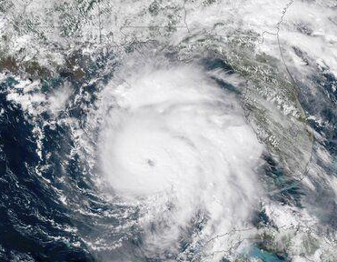
Hurricane Michael in the Gulf of Mexico in October 2018. NOAA recently upgraded Michael from a Category 4 storm to a Category 5, making Michael only the fourth tropical cyclone on record to hit the U.S. as a Category 5 hurricane. (Image credit: NOAA)

A cyclone is a general term for a weather system in which winds rotate inwardly to an area of low atmospheric pressure.

For large weather systems, the circulation pattern is in a counterclockwise direction in the Northern Hemisphere and a clockwise direction in the Southern Hemisphere.

Types of cyclones include tropical cyclones, extratropical cyclones and tornadoes.

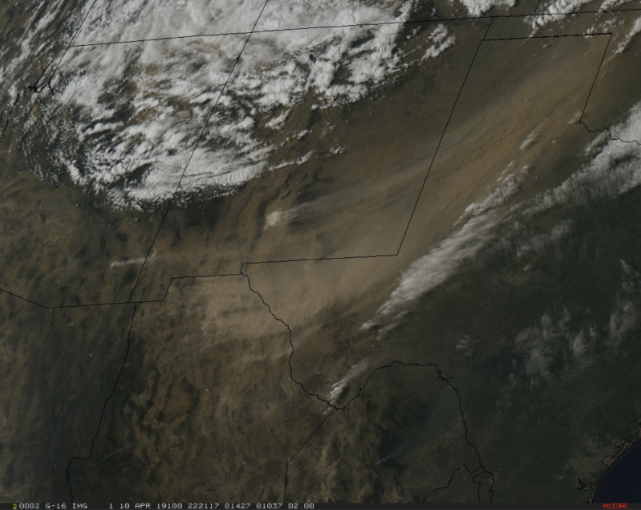
A tropical cyclone is a rotating low-pressure weather system that has organized thunderstorms but no fronts. They form over warm ocean waters.

Tropical cyclones with maximum sustained surface winds of less than 39 mph are called tropical depressions. Those with maximum sustained winds of 39 mph or higher are called tropical storms. When a storm’s maximum sustained winds reach 74 mph they are called hurricanes or typhoons. Hurricanes form over the Atlantic Ocean or Caribbean Sea; typhoons form over the western Pacific Ocean.

Extratropical cyclones are low-pressure systems that form outside of the tropics in response to a chronic instability of the westerly winds. Because this instability is dependent on large horizontal temperature contrasts, concentrated regions of temperature change known as fronts characterize extratropical cyclones.

These storms populate the middle and high latitudes, north of 35 degrees latitude in the Northern Hemisphere, and thus they also are called “mid-latitude cyclones.” If the barometric pressure of a mid-latitude cyclone falls by at least 1 millibar per hour for 24 hours, the storm is referred to as a “bomb cyclone.”

A tornado is a rapidly rotating column of air extending downward from a thunderstorm to the ground. The most violent tornadoes are capable of tremendous destruction with wind speeds of up to 300 mph.

Tornadoes form in regions of the atmosphere that have abundant warm and moist air near the surface with drier air above, and a change in wind speed and wind direction with height above the ground.

Category: Meteorology, Severe Weather

Comments Off on What is a cyclone?

Why was there a reddish tint in the snow this month?

Satellite image of the strong winds carrying dust from the southwestern deserts getting caught up into the April snowstorm that hit the upper Midwest. (Photo credit: CIMSS)

On April 10, there were strong winds associated with an intensifying mid-latitude cyclone over Arizona and western Texas. Winds were gusting as high as 77 mph in New Mexico and 88 mph in Texas.

The winds associated with this storm generated large plumes of blowing dust in southeastern Arizona, southern New Mexico, northern Mexico and western Texas. Willcox Playa, a dry lake in southeastern Arizona, was the source of some of the dust ranging in shades of tan to light brown.

Satellite observations tracked the movement of this dust, or aerosol, northeastward across the Upper Midwest. As the wind weakened, it deposited the dust on the ground, often on recently fallen snow, where it left a reddish tint.

Dust can be transported across the globe. Micrometer-size soil particles from deserts can be lifted by the wind to high altitudes and transported over thousands of miles. Desert dust from the Sahara and Gobi deserts has been observed on the ice sheet of Greenland.

Ice cores in Greenland provide a history of the dust deposition as they appear as layers in the ice. The mineralogy of the dust in the ice allows scientists to trace the desert of origin. The source also allows scientists to determine global wind patterns from thousands of years ago, as atmospheric circulation patterns that carry Saharan dust will be different than the global circulations that can transport dust from Asia to Greenland.

Category: Meteorology, Severe Weather

Comments Off on Why was there a reddish tint in the snow this month?

Is there a windiest time of year in Madison?

Matt Erdmann, of Madison, takes advantage of a winter wind as he kiteboards at Olbrich Park along the shore of Lake Monona. The climatology suggests that March and April are the windiest months, with average wind speeds of 11.3 and 11.4 mph, respectively, but November through February are not far behind, logging a four-month average of 10.5 mph. (Photo credit: Amber Arnold, State Journal Archives)

Given our recent weather, and with the pollen season dawning in southern Wisconsin, one may wonder if there actually is a windiest time of year in Madison.

Of course, a windy day can come along just about any time of year (the record gust of 83 mph in Madison occurred in June 1975) but the climatology suggests that March and April are the windiest months of the year with average wind speeds of 11.3 and 11.4 mph, respectively. November through February are not far behind, logging a four-month average of 10.5 mph.

The fact that it’s windier during the cold season is not surprising as that time of year is characterized by the highest frequency of mid-latitude cyclone activity. Mid-latitude cyclones are large in scale, covering several states simultaneously, and are often associated with very large differences in sea-level pressure over small distances. It is these pressure differences that drive the wind.

The particular maximum in March and April may reflect the fact that late winter and early spring storms have a higher chance of containing thunderstorms that can locally enhance the winds. It may also be that on a sunny March or April day the daytime heating contributes to a slightly breezier day than might be observed on a similarly sunny day in the depth of winter.

With regard to the pollen issue, it is interesting that the windiest month (April) occurs when plants are most in need of assistance in spreading pollen and reproducing. The power of evolution!

Category: Climate, Seasons, Weather Dangers

Comments Off on Is there a windiest time of year in Madison?

When does winter really end?

A large snow sculpture graces State Street Mall the day after Madison saw 7.2 inches of snow last year on April 18, more than doubling the day’s previous record for snowfall of 3.4 inches in 1912. (Photo credit: Steve Apps, State Journal Archive)

Last year’s 7 inches of snow on April 18 provided vivid evidence that, though early April often brings the first string of nice spring days to southern Wisconsin, we are not truly out of the woods until the end of the month.

Despite the possibility of such an outlier event, recent research at UW-Madison has considered the variability of the end of winter based purely on temperatures above the surface.

Specifically, we have considered the areal extent of air colder than 23 degrees at about 1 mile above the surface over the Great Lakes states.

We use the average areal extent of such air in the region, over the last 70 winters (December, January and February), as a threshold by which to consider the end of winter.

Any day in March or April of any year on which that day’s areal extent of cold air exceeds the 70-year December-January-February average is deemed a “qualifying cold day.” The last day of the last three-day or longer streak of such “qualifying cold days” in a given winter season is considered the end of winter.

Though the end of winter defined this way is highly variable from one year to the next — and bears absolutely no relation to how severe or mild the preceding months of that winter have been — over the last seven decades the average end of winter has become earlier by just over one week in our region.

This regional trend is consistent with the overall global trend of slight warming but, as we all no doubt remember well, does not preserve us from the occasional late-in-the-season reminder that winter leaves only grudgingly.

Category: Meteorology, Seasons

Comments Off on When does winter really end?

What is the Coriolis force?

We need to account for the Coriolis force to correctly analyze the large-scale movement of air in the atmosphere and water currents in the ocean. (Photo credit: Jim Buchta, Minneapolis Star Tribune)

Newton’s laws of motion mathematically describe how objects move when forces are exerted on them.

Earth is spinning like a top, even though to us who are standing on Earth, it seems that we are not moving. Newton did not account for Earth’s spin in his equations. The Coriolis force appears as an extra term when Newton’s laws are transformed to account for Earth’s spin.

Italian scientist Giovanni Battista Riccioli described the effect in 1651, explaining that Earth’s rotation causes a cannonball fired to the north to deflect to the east. Gaspard-Gustave Coriolis published a paper in 1835 describing the force mathematically.

The Coriolis force acts in a direction perpendicular to Earth’s rotational axis. Objects in the Northern Hemisphere are deflected to the right, while objects in the Southern Hemisphere are deflected to the left.

The magnitude of the Coriolis force depends on the speed of the object and its latitude. The Coriolis force is zero at the equator and increases toward the poles.

The Coriolis force also is proportional to Earth’s rotation rate. Earth completes one rotation per day, so for everyday motions, like throwing a ball or an apple falling from a tree, the Coriolis force is very small compared to other forces and is negligible. Its effects become noticeable only for motions occurring over large distances and long periods of time.

Because Earth spins, we need to account for the Coriolis force to correctly analyze the large-scale movement of air in the atmosphere and water currents in the ocean. It is too small to explain the rotation of draining water in sinks and toilets.

Category: Meteorology, Phenomena

Comments Off on What is the Coriolis force?