What weather is hazardous to flying?

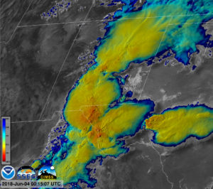
Thunderstorms create multiple hazards for aviation such as updrafts, turbulence, lightning and hail.

While there are weather hazards, flying is pretty safe.

Thunderstorms are a potential hazard, and aircraft avoid thunderstorms to avoid any potential threats or dangers.

Jet aircraft carry weather radars to detect and thus avoid the violent updrafts of storms. These updrafts have strong, turbulent winds and can carry hail.

You probably have experienced hail falling on the ground, but hail can also cause damage to planes flying at 10,000 or even 30,000 feet. On August 7, 2015, an Airbus A320 carrying 119 passengers and five crew members encountered hail, turbulence and lightning within a rapidly developing thunderstorm . It suffered cracked windshields and failed weather radar. No one was injured, although the pilot made an emergency landing at the Denver airport and the nose of the plane suffered hail damage.

Turbulence is also a danger to high-flying jets. Turbulence generated by a thunderstorm can cause the aircraft to violently “shake” even if only flying close to a storm. Clear-air turbulence, or CAT, is the turbulent movement of air in the absence of any visual clues, such as clouds.

Lightning can strike a plane, but generally doesn’t do damage as the bolt enters the aircraft extremities, such as the nose, tail or wing tips.

Icing is particularly dangerous to planes. When a plane is flying in temperatures below freezing while inside a cloud, very cold liquid water drops freeze onto the aircraft as soon as they strike the plane. Ice on the wings can disrupt the lift of the plane causing it to lose altitude. De-icing a plane before take-off prevents build up of ice on the plane.

The downdrafts of a storm can be very dangerous to aircraft on take off or landing. A downdraft can result in rapid wind shift from a tail wind to a head wind causing the aircraft to rapidly lose altitude. Fortunately, airports are equipped with instruments that can detect hazardous conditions and send warnings that keep the planes from encountering these dangerous conditions.

Category: Severe Weather, Weather Dangers

Comments Off on What weather is hazardous to flying?

When is spring?

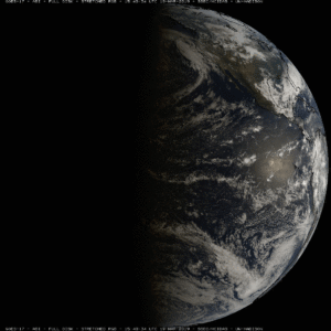
Satellite view of Earth at the Equinox.

The seasons result from the tilt of the Earth and its yearly circling of the Sun. According to the astronomical definition, spring occurs when the Sun’s rays strike the equator at noon at an angle that is directly overhead. This particular time varies from year to year due to variations in the Earth’s orbit about the Sun. In the Northern Hemisphere the Vernal (or spring) Equinox (equi, ‘equal,’ and nox, ‘night’) occurs sometime between March 19 and 23, but often on March 20 or 21. This year astronomical spring arrives on March 20 at around 4:58 P.M. CDT.

During the equinoxes all locations on Earth experience 12 hours of daylight and 12 hours of darkness. The Sun rises due East and sets due West. Equinoxes are the only two times a year that Sun only rises due east and sets due west for every location on Earth!  After the Spring equinox, the Northern Hemisphere tilts toward the Sun, and we start to get longer, sunnier days.

Spring marks the transition from winter to summer. Meteorologists divide the year into quarters to compare seasonal and monthly statistics from one year to the next. Meteorological spring is defined as March through May and so begins on March 1. We might also define spring as the day on which, if there is precipitation, it is more likely to be in the form of rain than snow. For southern Wisconsin, that occurs later in the month of March.

We may also define spring based on the appearance of a particular flower, the blooming of certain trees, or the return of specific migrating birds. These are the phenological signs of spring. Some mark spring by the increase in the number of pot-holes.

Whatever the definition, during spring the length of daylight hours is increasing and the air is warming. That’s welcome news for many people, particularly after our recent cold and damp weather.

Steve Ackerman and Jonathan Martin, professors in the UW-Madison Department of Atmospheric and Oceanic Sciences, are guests on WHA radio (970 AM) at 11:45 a.m. the last Monday of each month.
Category: Climate, Seasons

Comments Off on When is spring?

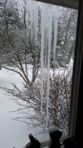
Why are icicles shaped like long skinny carrots?

4-foot long icicles! (Photo credit: Jackie Von Behren,
Town of Vienna)

Icicles typically form on days when the outdoor air temperature is below freezing but sunshine warms and melts snow or ice.

Thus, you may notice that more icicles form on the sunny south-facing side of your home than on the shaded north side.

When the sun melts snow or ice on your roof, the water flows downward and begins to drip off the roof. As the water first trickles over the edge, it forms a pendent drop suspended in the cold air. The air is below freezing, so the suspended drip starts to freeze. A thin outer-shell of ice forms on the drop. The icicle begins to form from this pendent drop.

For an icicle to grow, there must be a constant layer of water flowing over it, forming a thin fluid layer of water around the icicle. This is why icicles can feel very slippery.

The water runs down the sides in a thin film and freezes on the way down. When liquid water freezes, it releases heat. As the water along the sides of the icicle begins to freeze, the heat released by the freezing is transferred to the colder air in contact with the icicle. This small amount of heat makes a warmer layer of air that rises alongside the icicle, as it is warmer than the surrounding environment.

As this air flows upward along the icicle, it removes heat from the outer liquid layer, some of the water freezes, and the icicle grows thicker as it elongates. An icicle grows downward with an ever-progressing tip.

An icicle stops growing if water flow decreases or stops entirely. Icicles seen on a very cold day may be completely frozen, relics from a period when conditions were favorable for icicle formation. Actively growing icicles have liquid drops at the tip, and a narrow, liquid-filled tube extending upward from the tip.

Category: Meteorology, Phenomena

Comments Off on Why are icicles shaped like long skinny carrots?

What is the best weather forecast model?

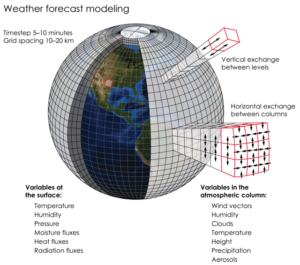
This graphic illustrates the huge number of variables that go into weather forecast models. 
Credit: K. Cantner, AGI.

If you are not a student of meteorology, you should rely on your local weather forecasters for a good weather forecast — and southern Wisconsin has some very good local forecasters. It is their job to interpret the various numerical weather prediction models.

Numerical weather prediction models, or NWP, solve a complex set of mathematical equations that are based on the physics that drives how the air moves and how heat and moisture are exchanged throughout the atmosphere.

The two best-known NWP models are the National Weather Service’s Global Forecast System, or GFS, and the European Center for Medium-Range Weather Forecast, known as the ECMWF model. They are also known as the American and European models, respectively. Generally speaking, the European model has produced the most accurate global weather forecasts.

If physics drives these models, how can these NWP models result in different weather predictions? Because of the complexity of the mathematical equations, each model has to make some approximations, and these approximations may differ. In addition, each model assimilates observations a bit differently.

A numerical forecast is only as accurate as the observations that go into the forecast at the beginning of its run, also known as the “initial conditions.” Because weather moves from one place to another rapidly, tomorrow’s weather is influenced by today’s weather far upstream, and next week’s weather can be affected by today’s weather a continent away. For this reason, forecasters need lots of worldwide data. Today we have global sources of data of many different types to give the forecast the best possible start.

Category: Climate, Meteorology

Comments Off on What is the best weather forecast model?

Why is ice different colors?

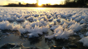
White ice crystals on the clear frozen surface of Madison’s Lake Mendota during January 2016.
Credit: Ilya Razenkov, SSEC

Some ice is called “black ice,” which refers to one of two conditions: A new layer of clear ice on water, which appears dark in color because the ice is transparent and so we see the deep water below; or a layer of clear ice on a roadway, which makes for hazardous driving conditions.

In both of these cases, the ice is not actually black but is transparent and therefore shows the color of the underlying surface.

When ice is clear, it’s because no air bubbles have been trapped in it. Lots of trapped air makes an object look white. You may have noticed that your ice cubes usually look cloudy and opaque in the middle. The water from your faucet has dissolved gases and minerals in it.

As ice forms, the process of freezing excludes impurities in the water from becoming part of the ice structure. In an ice cube tray, the water freezes from the outside and moves inward, and so the impurities are pushed into the middle of the ice cube and get trapped there — making it look cloudy in the middle. Snow looks white because of air trapped between crystals.

Lakes freeze from the surface downward. If a lake freezes slowly, the impurities and gases are pushed into the water below, resulting in clear ice.

The danger of driving on a road covered with black ice is that the roadway can appear to be merely wet. Drivers may not recognize the slippery conditions until it is too late and their cars begin to skid.

If your car has a thermometer, its temperature reading can help you determine hazardous road conditions. If your car’s thermometer measures an air temperature near freezing you should be wary of the road conditions. Because bridges span the open air, they cool faster than the roadways around them. Black ice may first occur on bridges; hence the warning signs “Bridge May Freeze Before Road.”

If a sidewalk is covered with clear ice, it may look dark gray — like a wet sidewalk. This “gray ice” can be hazardous to walking.

Category: Seasons, Weather Dangers

Comments Off on Why is ice different colors?