Does this cold wave prove the globe is not warming?

What had been a warmer than normal December, with the first 22 days averaging nearly 4.8 degrees above normal, was transformed to slightly below normal by a dramatic cold wave to end the month.

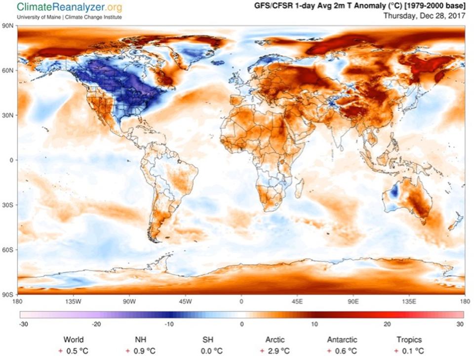
Global Temperature Anomalies
(departures from normal )
on December 28, 2017.
Credit: Climate Reanalyzer

Over the last week of December we averaged about 11 degrees below normal. This sudden change, though not unprecedented, was foreseen in various medium-range forecasts made before Christmas. But it has captured the nation’s attention as 2017 draws to a close.

Unfortunately, some of that attention may contribute to misunderstanding — motivated by President Trump’s recent statement suggesting such a cold wave provides evidence that his administration’s denial of climate change has been vindicated. Defense of the reality of global warming is particularly challenged by the cherry-picking skeptic during winter, as any period of below-average temperatures, and every winter will have some, is construed as evidence to the contrary.

However, the facts are that December 2017 was the 15th-warmest of the past 70 Decembers and that the areal extent of Northern Hemispheric cold air poked barely above average for the first time all month just a couple of days ago. This is consistent with a systematic warming of the Northern Hemisphere winter over the past seven decades that is unequivocally a manifestation of increased CO² concentrations and the associated global warming.

Science extends our collective “senses” to provide evidence of the workings of the natural world. As leader of our great country, the president has an obligation to assess his skepticism in the face of empirical facts. To do less is to neglect the duties of his office.

Steve Ackerman and Jonathan Martin, professors in the UW-Madison department of atmospheric and oceanic sciences, are guests on WHA radio (970 AM) at 11:45 a.m. the last Monday of each month.
Category: Uncategorized

Comments Off on Does this cold wave prove the globe is not warming?

Did climate change kill the dinosaurs?

Landsat image of the Sudbury Basin in Ontario,
the remnants of an asteroid impact that
occurred ~1.8 billion years ago.  Credit: USGS.

Sixty-six million years ago, the age of the dinosaurs ended abruptly, coinciding with the extinction of about 75 percent of the total number of living species.

Evidence and climate modeling indicate that global wildfires resulted from a collision with a massive asteroid that could have lofted large amounts of soot into the atmosphere. The smoke would have plunged Earth into darkness for nearly two years, which would have shut down photosynthesis, drastically cooled the planet, and contributed to the mass extinctions as evidenced in the fossil record.

It is now an accepted scientific fact that objects from outer space can and do collide with planets. The collision of the Shoemaker-Levy comet with Jupiter in 1994 provided spectacular evidence that extraterrestrial objects can affect a planet’s atmosphere.

Depending on its exact location, a major asteroid impact on Earth and the debris ejected by the impact can cause extended darkness due to global fires, acid rain, ozone loss and even mile-high tsunamis.

In 1990, evidence was discovered of an impact with an asteroid that occurred about 66 million years ago near the Yucatán Peninsula. Named for a local village, the Chicxulub crater is a 112-mile-wide impact crater visible in gravity and magnetic field data. The crater size is consistent with a 6- to 12-mile-wide asteroid.

Remnants of the asteroid have been found in sediments worldwide, confirming its global influence. The Chicxulub impact was probably not a once-in-history event. There are indications in the fossil record of other extinction events that occur every 26 million years or so.

Scientists are coming to the realization that on very long time scales the history of Earth, including its climate, may be periodically upset by asteroid and comet impacts.

Steve Ackerman and Jonathan Martin, professors in the UW-Madison department of Atmospheric and Oceanic Sciences, are guests on WHA radio (970 AM) at 11:45 a.m. the last Monday of each month.
Category: Climate, Phenomena

Comments Off on Did climate change kill the dinosaurs?

Can weather satellites see the fires in California?

GOES-15 IR detection of California wildfires
on 12/5/17, from the CIMSS Satellite Blog.
(click to animate)

Sensitive instruments on some weather satellites can see the fires, but only at night. They do not see individual trees burning but they detect that a region is on fire. We can see the flames during the night because it’s dark and that increases contrast. During daytime, solar illumination reduces this contrast and thus detectability.

The instruments onboard satellites can detect byproducts of the fires 24 hours a day. For example, during the daytime, observations at wavelengths associated with the color blue can detect the smoke from the fires. They can pinpoint the origin of the smoke, and thus the fires.

Satellites can track the smoke as it is transported away from the fires. The smoke can be transported by the winds to the ground and become an air quality issue. In dense concentrations the smoke can have health impacts for those with asthma conditions.

Instruments onboard satellites also can detect the heat emitted by the fires. These instruments make observations at infrared wavelengths — wavelengths our human eyes cannot see — and work during the daytime and nighttime. At these wavelengths, smoke is transparent so even if the smoke is thick, the instruments can see through the smoke to the heat generated by the flames.

The new geostationary satellites, ones that appear to be fixed above Earth, are used to detect and monitor the fires. Observations can be made every 30 seconds, which allows forecasters to track the direction the fire moves and also the intensity of the fire. This is very useful information in fighting the fires. Satellite measurements can also be used to estimate how much material is being consumed by the fires.

Once the fires are extinguished, satellites can measure the size of the burn scar. Over time we can observe how new vegetation grows into the burned area and the ecological recovery.

Steve Ackerman and Jonathan Martin, professors in the UW-Madison department of Atmospheric and Oceanic Sciences, are guests on WHA radio (970 AM) at 11:45 a.m. the last Monday of each month.
Category: Uncategorized

Comments Off on Can weather satellites see the fires in California?

Will the roller coaster of early winter temperatures continue?

The past month was very clearly split into two nearly equal but opposite halves temperature-wise.

The first 15 days of November were routinely, though not exclusively, below normal with 10 days falling into that category. In fact, the eight days from Nov. 6 to Nov. 13 were consecutively below normal, with the morning low of 9 degrees on Nov. 10 setting a daily record.

The early cold left us averaging 5.1 degrees colder than normal through November 15. Only three additional below-normal days occurred after the halfway point. Remarkably, beginning on Nov. 23, the month ended with eight consecutive days of above-normal temperatures, including the record high of 64 degrees on Nov. 24.

The warm second half of the month averaged 3.9 degrees above normal so, overall, November was just 0.6 degrees colder than usual even after its brutally cold start.

This latest extended period of unusual warmth will be over after today, however. Forced by the influence of successive strong cyclones in the Gulf of Alaska at the end of November, the mid-tropospheric flow over North America has transformed quickly. We are now poised to intercept a cold northwesterly flow originating in far northwestern Canada.

Overnight into Tuesday, temperatures will plummet as we head into an extended and exceptional cold snap to start December. The lack of snow cover will mitigate this upcoming chill to a great extent, but it is likely we will not enjoy another warm day like today for some time. Enjoy it while you can.

Steve Ackerman and Jonathan Martin, professors in the UW-Madison department of atmospheric and oceanic sciences, are guests on WHA radio (970 AM) at 11:45 a.m. the last Monday of each month.
Category: Uncategorized

Comments Off on Will the roller coaster of early winter temperatures continue?

How are the National Weather Service and Wisconsin connected?

The roots of our National Weather Service have a distinctive Wisconsin flavor. Professor Increase A. Lapham, a University of Wisconsin professor at the time of the founding of the university, was the first official Smithsonian Institution weather observer in Milwaukee and long argued for the establishment of a national weather observation network.

With the election of President Ulysses S. Grant in November 1868, Lapham and Rep. Halbert Paine, the U.S. congressman from Milwaukee, thought the time was right to pursue this goal. Grant had developed a keen sense of the influence of weather on military operations through his experiences in the Civil War.

On Feb. 2, 1870, Paine introduced a Joint Congressional Resolution that tasked the Secretary of War “… to provide for taking meteorological observations at the military stations in the interior of the continent and at other points in the States and Territories … and for giving notice on the northern [Great] lakes … of the approach and force of storms.”

Congress passed the resolution with little hesitation and a week later, on Feb. 9, 1870, President Grant signed it into law – effectively establishing the first iteration of the National Weather Service (then called the U.S. Army Signal Service). Operation of the Signal Service began Nov. 1, 1870, and one week later, Lapham issued the first high wind warning for the Great Lakes from Chicago. The forecast was accurate and was credited with saving considerable property and protecting lives.

The Wisconsin connection to the National Weather Service continues to this day, as the current director of the NWS is a UW-Madison graduate, Dr. Louis Uccellini.

NWS Director Louis Uccellini awards ‘Storm-Ready’ plaque to UW-Madison Chancellor Becky Blank in 2015. Photo credit: Bill Bellon

Steve Ackerman and Jonathan Martin, professors in the UW-Madison Department of Atmospheric and Oceanic Sciences, are guests on WHA radio (970 AM) at 11:45 a.m. the last Monday of each month.

Category: Meteorology

Comments Off on How are the National Weather Service and Wisconsin connected?