What caused last month’s flooding?

Tyler Statz takes a break from cleaning out his flooded home in Black Earth. The village and nearby towns were swamped when nearly 15 inches of rain fell in the area. (Photo credit: Steve Apps, State Journal)

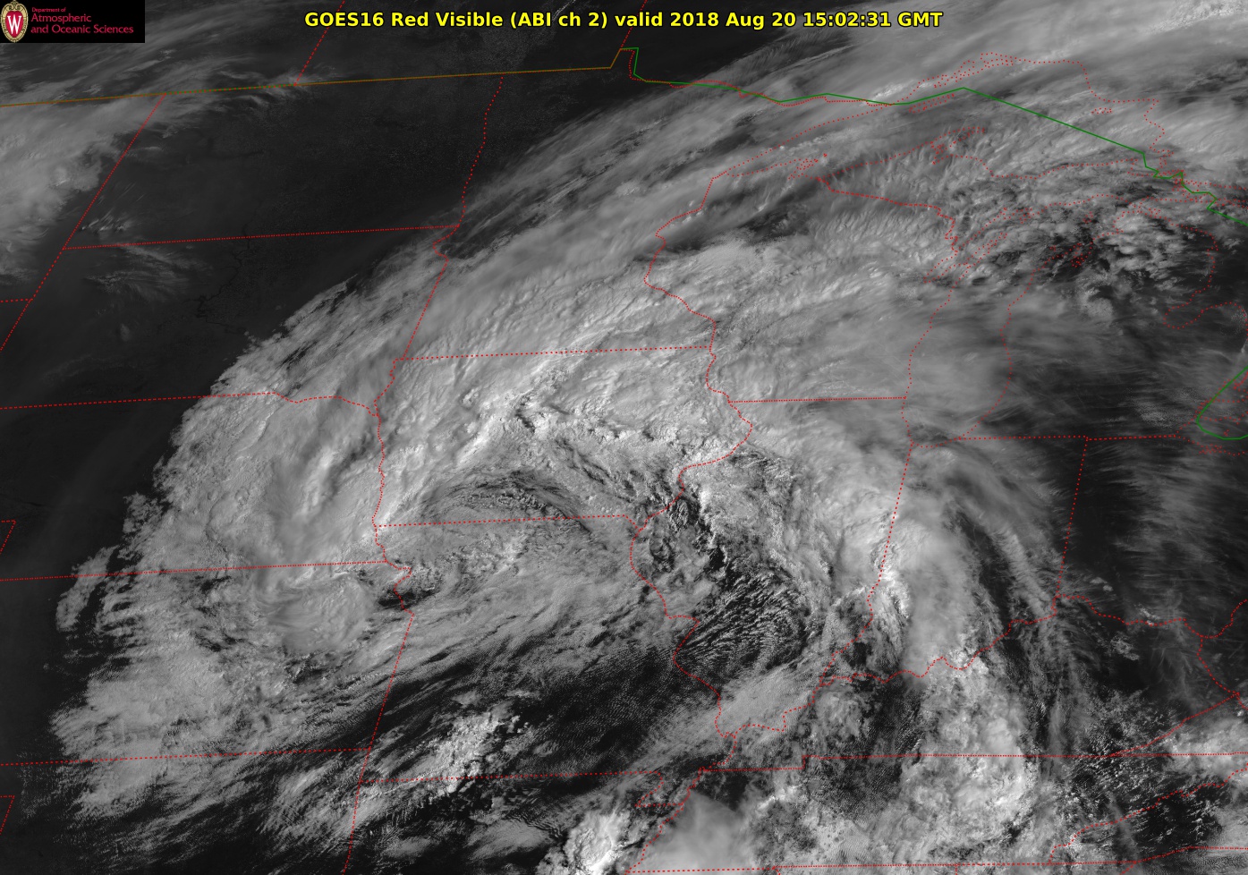
The nearly unprecedented flooding that has plagued the southern half of the state over most of the last two weeks began with the incredibly heavy rains that fell on Dane County and surrounding areas in the afternoon and evening of Aug. 20.

Western parts of Middleton recorded over 12 inches of rain, and a staggering total of 14.7 inches fell in Cross Plains in well less than 24 hours.

The Cross Plains total now represents the single greatest 24-hour rainfall event in the state’s history, eclipsing the 11.72 inches that fell near Mellen on June 24, 1946.

A curious aspect of the heavy rain that night, at least in Madison (where 3.92 inches fell during the event), was that it was relatively lightning free as such summer downpours go. That observational characteristic is an important clue about the mechanisms that forced this state-record rain event.

Like the substantial rain that preceded it on Aug. 17, this precipitation was tied to passage of a mid-latitude cyclone that ingested extremely vapor-rich air into its circulation.

A week later, the devastating precipitation amounts were shifted northwest toward the La Crosse, Sparta and Viroqua area where, again, widespread heavy rain (near 12 inches in some locations) resulted in record flooding of the Kickapoo River.

The storms responsible for that flooding were more like the heavily precipitating convective storms we are used to here in the summer.

Category: Meteorology, Severe Weather

Comments Off on What caused last month’s flooding?

What is a 100-year storm?

Flooding in Mazomanie WI on August 21st.
Photo credit: Casey Heron

The phrase “100-year storm” refers to the estimated probability of a storm event happening in any given year.

A 100-year event has a 1 percent chance (or 1-in-a-100 chance) of occurring in any given year. The term “100-year flood” allows us to place a particular weather event in context with other similar events.

It is wrong to think that a 100-year storm happens only once every 100 years. While not likely, two 100-year storms can occur within a week of each other.

These 100-year storms are often considered in terms of the precipitation that comes with the storm and the flooding that results.

A flood occurs when water flows into a region faster than it can be stored in a lake or reservoir, absorbed into the soil, or removed by runoff into a drainage basin. There are several conditions that can result in flooding: a long-lasting rainfall over a watershed, intense rainfall, or rainfall that causes rapid snow melt.

The recent flooding in the Madison area (which will be addressed in next week’s column once certain potentially record-breaking measurements can be verified) resulted from record-breaking rainfall over one watershed and heavy rainfall over another. Because floods result under different circumstances and in different places, their impacts vary.

Scientists collect data on how frequently different sizes of floods occur and the time between these floods. They use this data to calculate the probability that a flood of a particular size will be equaled or exceeded during any year.

The term “100-year flood” is a statistical designation of an unlikely event. Statistically, a 100-year flood has about a 63 percent chance of occurring in any 100-year period, not a 100 percent chance of occurring. Extreme and unlikely values are important for assessing the risk of unusual events.

Steve Ackerman and Jonathan Martin, professors in the UW-Madison Department of Atmospheric and Oceanic Sciences, are guests on WHA radio (970 AM) at 11:45 a.m. the last Monday of each month.
Category: Uncategorized

Comments Off on What is a 100-year storm?

What forces a mid-latitude cyclone to develop?

Mid-level cyclone from August 18 via GOES-16.

Our rainy Friday was arguably the first storm, or cyclone, of the autumn/winter season. Though it will surely be followed by more powerful examples, you may well have wondered how do such storms come to be?

That has been the central motivating question in meteorological science for most of the past 100 years. During that time, meteorologists have learned a great deal about how these mid-latitude cyclones are formed.

In most instances, two or more days before the storm is noticed at the surface of the Earth, processes are at work in the upper troposphere. Specifically, at the height of the jet stream (about 6 miles above the surface), weak downward vertical motions begin to drag the tropopause downward into the middle troposphere. This process eventually results in the creation of a mid-level vortex, a region of counterclockwise-rotating winds, about 3 miles above the ground.

Once generated, this vortex is then moved around by the atmospheric winds in its vicinity. At the forward side of this moving vortex, the air is forced to rise. Such upward vertical motion evacuates air from the lower troposphere, lowering the pressure at the surface.

Simultaneously, the upward vertical motion produces clouds and precipitation. So long as the mid-level vortex continues to intensify and move, so too does the surface cyclone. In many cases, the mid-level vortex eventually becomes quasi-stationary and positioned directly above the surface cyclone. This usually marks the end of the intensification for the storm though it can still deliver high-impact weather at this stage.

Category: Meteorology, Seasons

Comments Off on What forces a mid-latitude cyclone to develop?

When is tornado season?

A tornado that touched down Thursday in Deerfield, though relatively weak, tore a roof off International Machinery Exchange, 214 N. Main St. (Photo credit: John Hart, State Journal)

Tornadoes form in regions of the atmosphere that have abundant warm and moist air near the surface with drier air above, a change in wind speed and direction with height, and weather systems such as fronts that force air upward.

The United States provides these three ingredients in abundance, so it is not surprising that the majority of the world’s reported tornadoes occur in the U.S.

Within the United States, tornadoes can occur in nearly every state and in every month of the year. Wisconsin has experienced tornadoes in every month except February.

Tornado season is based on when the ingredients for severe weather come together in a particular place. Because a change in wind with height is closely related to the presence of a jet stream, tornado season moves north and south during the year with a jet stream.

Tornado season peaks in March and April in the Southeast but not until July in the upper Midwest and Northeast. The deep South has a secondary peak in tornado occurrence in November.

Tornadoes can also happen at any time of day or night. However, the most likely times for tornadoes are late afternoon or early evening. More than half of all U.S. tornadoes occur during the hours of 3 p.m. to 7 p.m. local time.

In Wisconsin, June is typically the month when the most tornadoes occur, followed by July. Wisconsin averages 24 tornadoes per year.

So far this year, Wisconsin has experienced only eight tornadoes. The most recent was Thursday in Deerfield. The National Weather Service determined that tornado had 80-mph winds. The storms were relatively weak, in comparison to other tornadoes, but they still caused damage and posed a danger.

Category: Meteorology, Severe Weather

Comments Off on When is tornado season?

Why did the end of July have nice weather?

A bicyclist enjoys relatively cool weather while viewing the backdrop of the La Crosse River Marsh and the bluffs beyond while riding along Lang Drive on July 26. The cooler temperatures across Wisconsin and much of the Midwest in the last week of July resulted from a Canadian high-pressure system that settled over the central U.S. (Photo credit: Peter Thomson, La Crosse Tribune)

During the last week of July — the 25th through 31st — the temperatures across Wisconsin were 1 to 4 degrees below normal. In fact, much of the Midwest was cooler than normal.

The cooler temperatures resulted from a Canadian high-pressure system that settled over the central U.S. during that final week of July.

The Canadian high-pressure is a semi-permanent atmospheric high-pressure system that is associated with generally low temperatures over northern Canada. The Canadian Rockies keep the relatively warm air over the Pacific Ocean from warming Central Canada and the air masses that form there.

In winter the Canadian high consists of cold dense air, and extends only about 2 miles above the surface. When the system moves southeastward in winter, it can bring frigid air to the Midwest. In summer, it provides refreshing cool dry air to our region.

High-pressure systems have sinking air above that inhibits rain clouds from developing. Large areas of southern Wisconsin had less than half the normal amount of rainfall for this time of year. The sinking motions also lower the humidity. High pressures are accompanied by light winds.

The Canadian high-pressure system is generally associated with nice weather in summer. Other high pressure systems, particularly those that form over the Gulf of Mexico and move northward, can be accompanied by high humidity and pose a threat if the heat index is high.

Category: Climate, Seasons

Comments Off on Why did the end of July have nice weather?