Is Madison breaking any records during the warmest year ever across the globe?

Jennifer Ronquillo, of Madison, plays with her daughters at opening day at the Goodman Pool on June 10 -- Madison's first 90-degree day of the year and the third day of a record-shattering 110-day streak of temperatures at or above 70 degrees. (Photo credit: Amber Arnold, State Journal)

Jennifer Ronquillo, of Madison, plays with her daughters at the Goodman Pool on June 10 — the pool’s opening day, Madison’s first 90-degree day of the year and the third day of a record-shattering 110-day streak of temperatures at or above 70 degrees. (Photo credit: Amber Arnold, State Journal)

Sunday was the 110th consecutive day in Madison with a daily high temperature at or above 70 degrees, shattering the previous longest such streak of 103 days, set in 1998, by seven days.

We are also approaching the record for the number of consecutive days with a daily minimum temperature at or above 45 degrees, set in 2010 when a streak of 128 such days occurred. As of Sunday, this year’s string was at 127. Low temperatures forecast around 45 degrees for Monday through Wednesday could maintain or break that streak.

Though the period of record for minimum temperatures extends back only to 1947, it is conspicuous that 10 of the top 15 such stretches have occurred since 2005. Though such lengthy streaks can result from lucky circumstances — such as a peak of sun on an otherwise cloudy day where the temperature seemed doomed to reach a maximum in the high 60s — it is nonetheless noteworthy that both the streaks have occurred in the warmest year the globe has ever recorded.

Also this past week, the National Snow and Ice Data Center in Boulder, Colorado, reported that the areal extent of the sea ice in the Arctic, which in March of this year recorded its record low maximum extent, was the second lowest on record at the end of the summer (satellite records go back to 1978).

Despite the plethora of local and global data supporting the notion that the earth is warming and that it’s a function of human-induced changes to the chemical composition of the atmosphere, skepticism remains stubbornly widespread. As scientists, we are eager for the debate to become focused on the array of responses society might take in response to the threat rather than continuing to argue over whether or not climate change exists.

Category: Climate, Meteorology, Seasons

Comments Off on Is Madison breaking any records during the warmest year ever across the globe?

Can Pacific hurricanes influence our weather in North America?

A man earing a red helmet, left, climbs on the wreckage of a destroyed structure after a typhoon in Xiamen in southeastern China's Fujian province on Thursday. Typhoon Meranti, labeled the strongest storm so far this year by Chinese and Taiwanese weather authorities, made landfall in southeastern China early Thursday after previously affecting Taiwan. (Photo credit: Chinatopix)

A man earing a red helmet, left, climbs on the wreckage of a destroyed structure after a typhoon in Xiamen in southeastern China’s Fujian province on Thursday. Typhoon Meranti, labeled the strongest storm so far this year by Chinese and Taiwanese weather authorities, made landfall in southeastern China early Thursday after previously affecting Taiwan. (Photo credit: Chinatopix)

Super Typhoon Meranti, the strongest storm of the year, delivered a devastating blow to Taiwan on Tuesday and Wednesday.

The word “typhoon,” used commonly in the west Pacific, is a synonym for “hurricane.” The storm, which intensified from a category 1 to a category 5 hurricane in 24 hours, had estimated sustained winds of 190 mph for nearly a day after reaching that incredible strength.

Though such storms are an annual threat to Taiwan and the neighboring Philippines (a nation that endures more hurricanes each year than any place on Earth), a storm of Meranti’s strength has not made a direct hit on Taiwan since 1959. By the time the storm hit the far southwest tip of the island, the sustained winds had weakened to 115 mph but it still wrought widespread damage to the southern portion of the island.

The storm passed directly over Itbayit in the Philippines so that the small island could be seen in the eye of the storm on satellite images. Meranti subsequently barreled northwestward and made another landfall near Xiamen, China, on Wednesday afternoon with invigorated strength as winds were at an estimated 145 mph, with gusts to 175 mph. As is usually the case with hurricanes, Meranti’s winds weakened after its Chinese landfall, but the storm was still associated with very heavy rains, flashflooding and mudslides.

Though the most intense impacts of the storm are limited to the immediate landfalling areas, the broader atmosphere does respond to the presence of such a powerful hurricane in ways that can eventually affect the weather over North America. The forecast calls for unusual warmth over western Canada at the end of this week that may well have its origin in the interaction of the remnants of Meranti and the jet stream flow over the Pacific Ocean.

Category: Meteorology, Severe Weather, Tropical

Comments Off on Can Pacific hurricanes influence our weather in North America?

How does Hurricane Hermine measure up?

Water from Roanoke Sound pounds the Virginia Dare Trail in Manteo, NC, Saturday, as Tropical Storm Hermine passes the Outer Banks. Hermine lost hurricane strength over land but intensified along the Atlantic Coast. (Photo credit: Tom Copeland, Associated Press)

Water from Roanoke Sound pounds the Virginia Dare Trail in Manteo, NC, Saturday, as Tropical Storm Hermine passes the Outer Banks. Hermine lost hurricane strength over land but intensified along the Atlantic Coast. (Photo credit: Tom Copeland, Associated Press)

On Friday Hurricane Hermine made landfall in Florida, making it the first to make landfall in the state in more than a decade.

Hermine, which weakened to a tropical storm shortly after landfall as is commonly the case with weak hurricanes, was poised to redevelop and pose a threat to the Mid-Atlantic states and possibly southern New England into the middle of the week.

Eighty-one years ago, nearly to the day, the famous Labor Day Hurricane of 1935 struck Florida with greater intensity than any other landfalling hurricane in the country’s history.

While Hermine had sustained winds of about 75 mph and dropped nearly 17 inches of rain in the Tampa/St. Petersburg area, the Labor Day Hurricane made landfall with sustained winds near 185 mph.

Both storms developed within days of Sept. 12, the date of the average peak frequency for such storms in the Atlantic Basin. Though the number of tropical cyclones in an average year numbers in the low teens, these storms are deserving of attention because they can wreak enormous damage to life and property.

They also play a substantial role in ventilating the tropical ocean and mixing heat from the tropics, where an annual surplus accumulates, to the high latitudes where an annual deficit stands in need of remedy.

It may seem surprising given our location in the middle of the North American continent, but hurricane research, employing both satellite observations and theoretical advances, at UW-Madison has led the way toward improved understanding and forecasting of these powerful storms.

Category: Meteorology, Severe Weather, Tropical

Comments Off on How does Hurricane Hermine measure up?

Is this a rainy summer?

Chavez Elementary School students Josh Gonzales, left, and Dorgee Tsering enjoy a rain shower during a trip to the UW-Madison campus in May. Spring showers gave way to a rainy summer for southern Wisconsin. (Photo credit: John Hart, State Journal archives)

Chavez Elementary School students Josh Gonzales, left, and Dorgee Tsering enjoy a rain shower during a trip to the UW-Madison campus in May. Spring showers gave way to a rainy summer for southern Wisconsin. (Photo credit: John Hart, State Journal archives)

For southern Wisconsin, this has been a rainy summer.

This August, the precipitation that fell over southern Wisconsin is about 200 percent of normal.

Total precipitation was also above normal for June and July. With the summer coming to a close, we are about 6 inches above normal.

On Aug. 19, 2.74 inches fell on Madison, setting a daily record, beating the old mark of 2.13 inches set in 2007. In particular, August has been exceptionally rainy compared to the prior five Augusts, as the only above-normal August in that stretch occurred in 2014 (plus-1.14 inches).

In Madison, the official measurement is made at the Dane County Airport. Even given the convective nature of the storm systems, all of Wisconsin was above normal in terms of the average precipitation for the month of June.

Because of the good rain, there is no area in Wisconsin that currently is classified as experiencing a drought condition. The soil moisture content for most of southern Wisconsin is above normal. The water levels in Lake Mendota and Lake Monona are above their average maximum summer levels.

The convective nature of summertime precipitation makes the amounts vary widely across the county and even across the city. So it is important to make as many observations of rainfall as possible. If you are interested in contributing observations, you can join the Community Collaborative Rain, Hail and Snow networks, or CoCoRaHS. This community includes over 15,000 volunteers who help measure and report precipitation type and amounts every day.

Observations of precipitation by a large group of volunteers are critical to understanding storms as precipitation varies widely from place to place even in a single storm. Such observations are useful for assessing flooding hazards. You can join CoCoRaHS at www.cocorahs.org.

Category: Meteorology, Seasons

Comments Off on Is this a rainy summer?

Is another transition around the corner?

Convective clouds such as these from a storm over Hudson Bay in Canada last week can drop large amounts of rain very quickly. (Photo credit: Steve Ackerman, UW-Madison)

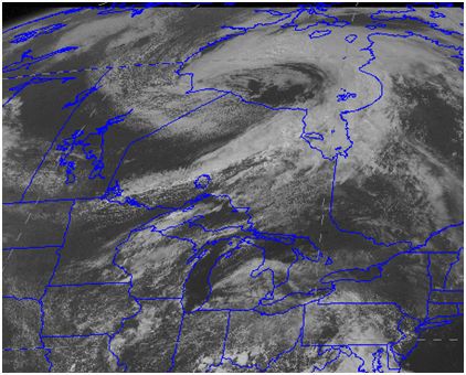
This classic comma shaped cloud, also called a mid-latitude cyclone, deepened over Hudson Bay Canada during mid-August 2016.
(credit: Steve Ackerman, CIMSS)

As we head into the second half of August a subtle transition in our weather begins to occur — one that is probably hard to detect at first but that eventually becomes very obvious and then lasts for approximately eight months.

We are not talking about the gradual reduction in daytime high temperatures or the increasingly cooler to cold nights, though these are also beginning to invade.

Instead, we are talking about the nature of the storms that deliver our precipitation.

Throughout the summer, most of our precipitation comes in the form of thunderstorms, wherein large amounts of precipitation fall in a short amount of time from what we call convective clouds.

Most often these storms have life cycles of only a few hours and drop precipitation over a relatively small area.

These characteristics also make the exact timing and location of summertime precipitation difficult to forecast.

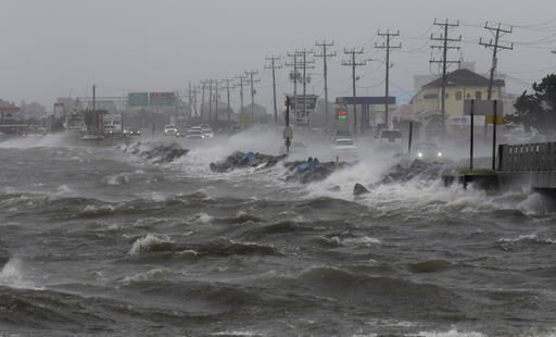
As we transition to late summer/early autumn, the thunderstorm frequency abruptly decreases and precipitation tends to occur in persistent, light to moderate rain events that will sometimes last an entire day.

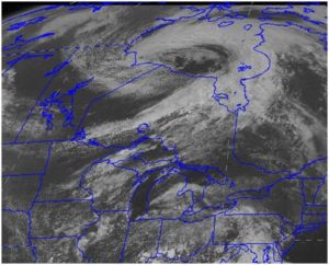
This mode of precipitation is associated with the passage of what are known as mid-latitude cyclones — storms that live for over a week, during which time they can cover an area the size of 10 states and characteristically take on a comma-shaped appearance in satellite imagery.

As they progress across the country, these mid-latitude cyclones can drop precipitation (rain or snow) over enormous portions of the country.

Though not entirely missing from summertime precipitation, such events are definitely the exception rather than the rule in the summer.

This past week, the first really well developed such storm of the season paraded across Hudson’s Bay in Canada and another one like it is poised to do the same late this week.

Category: Climate, Meteorology, Seasons

Comments Off on Is another transition around the corner?