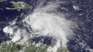
A GOES East satellite image provided by the National Oceanic and Atmospheric Administration (NOAA) on Thursday shows Hurrican Matthew — the first Category 5 hurricane in the Atlantic basin since Hurricane Felix in 2007 — in the Caribbean Sea about 190 miles northeast of Curacao. The category of a hurricane is determined by reconnaissance aircraft flights into the storm along with analysis of satellite images. The satellite approach is led by scientists at the UW-Madison as part of the Cooperative Institute for Meteorological Satellite Studies, or CIMSS (Photo credit: NOAA)
An obvious hurricane threat is its powerful wind, which can blow in a single spot for many hours.
Wind damage is such a hallmark of hurricanes that hurricane intensities are classified by meteorologists using the Saffir–Simpson scale, which rates hurricanes on a scale of 1 to 5 based on the damage their winds would cause upon landfall.
Major hurricanes are those classified as Category 3 and higher on this scale. Category 3 hurricanes have a one-minute sustained wind between 111 mph and 130 mph.
The one-minute sustained winds in a Category 5 hurricane are greater than 155 mph.
The category of a hurricane is determined by reconnaissance aircraft flights into the storm along with analysis of satellite images.
The satellite approach is led by scientists at UW-Madison as part of the Cooperative Institute for Meteorological Satellite Studies, or CIMSS.
This collaboration between the university and the National Oceanic and Atmospheric Administration (NOAA) supports research on weather satellites.
Hurricane Matthew intensified in the Atlantic Ocean this past weekend and will threaten the U.S. mainland this week.
A reconnaissance plane recently measured wind speeds in this storm and those measurements along with the CIMSS analysis led NOAA to list Matthew as a Category 5 storm.
This is the first Category 5 hurricane in the Atlantic basin since Hurricane Felix in 2007.
Fortunately, most hurricanes do not produce the extreme winds linked with the highest category on the Saffir–Simpson scale, but any category storm can do major damage when it hits land.
Flooding from hurricanes causes major damage to shorelines and buildings. The winds in a hurricane push ocean water in front of them. The stronger the wind, the more water is “piled up.”
As the hurricane nears shore, the wind pushes this water inland. This process of wind-induced seawater flooding is called storm surge.
Historically, the storm surge has caused as much as 90 percent of all hurricane-related deaths.
Flooding from rain can also be dangerous.
Hurricane Floyd made landfall in 1999 as a Category 2 storm. Flooding that ensued along the U.S. East Coast accounted for most of the death toll of 57.