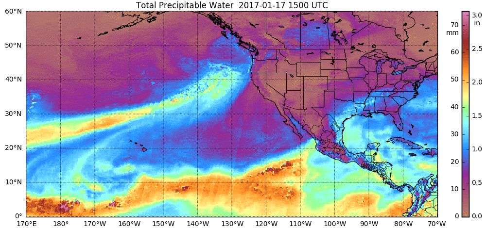
Was the whole autumn unusually warm, or just November?

Alvaro Ceballos enjoys November's mild weather as he stops to read at Vilas Beach on Lake Wingra on his way home from getting a haircut. Madison averaged 7.6 degrees above normal for the month, which ranked as the third warmest November on record. (Photo credit: Amber Arnold, State Journal)

Alvaro Ceballos enjoys November’s mild weather as he stops to read at Vilas Beach on Lake Wingra on his way home from getting a haircut. Madison averaged 7.6 degrees above normal for the month, which ranked as the third warmest November on record. (Photo credit: Amber Arnold, State Journal)

If you thought November was warmer than usual around southern Wisconsin, you were exactly right.

Madison averaged 7.6 degrees above normal for the month, which ranked as the third warmest November on record (since 1870).

The warmest November here occurred in 2001, when the average temperature was 9.8 degrees above normal.

For the entire autumn season, defined as Sept. 1 through Nov. 30, Madison averaged 54.5 degrees, placing it behind only 1931 (56 degrees) as the second-warmest autumn on record.

Similar rankings for both the month of November (second-warmest ever) and full autumn season (second-warmest ever) were also set this year in Milwaukee.

Perhaps even more interesting is the fact that in Madison, which has a continuous 146-year temperature record, nine of the warmest 25 Novembers have occurred since 1994.

If, despite the fact that variation in November and autumn average temperature occurs, there were no discernible trend, these warmest Novembers would be distributed nearly equally throughout the 146-year record. Therefore, we could reasonably expect one such unusual November every six years or so.

Thus, to have had nine of them (54 years worth) in the last 22 years is far ahead of the expected pace. In a similar fashion, we should have expected to wait about 41 years to have experienced seven of the warmest 25 autumns but it has only taken 22 years.

These facts strongly suggest that the high frequency of warm Novembers and warm autumns since 1994 is not a result of random chance.

It appears instead to be a manifestation of the general warming of the planet associated with global climate change.

Category: Climate, Seasons

Comments Off on Was the whole autumn unusually warm, or just November?

What is the status of the Arctic sea ice?

Ice floats in the Arctic near Svalbard, Norway, in April 2009. At the end of October 2016, the Arctic sea ice was at its lowest October coverage since satellite-based data records started in 1978.

Ice floats in the Arctic near Svalbard, Norway, in April 2009. At the end of October 2016, the Arctic sea ice was at its lowest October coverage since satellite-based data records started in 1978.

The year 2016 will go down as one with below-normal Arctic sea ice coverage.

While not quite a record-setting year like 2012, throughout much of 2016 the extent of sea ice was more than two standard deviations below the average. At the end of October the Arctic sea ice was at its lowest coverage for the month since satellite-based data records started in 1978.

This continues the recent decreasing trend observed in the Arctic over the last decade. As of November, the sea ice extent remains low over much of the Arctic Sea. In addition to having a smaller extent, the Arctic is losing it thickest and oldest ice. Scientists recognize that the decrease in sea ice is directly tied to the global warming that is being driven by human activity.

The decreasing ice can enhance this warming by what is referred to as a positive feedback. Sea ice is bright and reflects about 80 percent of the sunlight that falls on it, helping to keep the surface cool. When the ice melts, the ocean surface is exposed and is able to absorb the incident solar energy. This leads to a warming of the water and the air above, which can melt more ice, leading to an increased warming and more melting.

Since the sea ice is floating on the ocean, melting it does not cause the sea level to rise. Melting ice on land will cause the sea level to rise as it contributes to increased runoff. In addition, as the ocean waters warm, they expand, which further contributes to sea level rise.

Category: Climate, Meteorology, Seasons

Comments Off on What is the status of the Arctic sea ice?

What is a November gale?

A November gale is associated with the sinking of the Edmund Fitzgerald, a mammoth ore freighter, and the loss of its 29 crew members in 1975. The event was memorialized by Gordon Lightfoot's ballad "The Wreck of the Edmund Fitzgerald." (Photo credit: Associated Press)

A November gale is associated with the sinking of the Edmund Fitzgerald, a mammoth ore freighter, and the loss of its 29 crew members in 1975. The event was memorialized by Gordon Lightfoot’s ballad “The Wreck of the Edmund Fitzgerald.” (Photo credit: Associated Press)

A gale is a sustained wind between 39 mph and 54 mph.

Gales are usually caused by large differences in the air pressure between a low pressure system and a strong, high pressure system.

Gale winds are common in November on the Great Lakes; however, we have not experienced such gale winds this year. Indeed we have had a very mild November.

In the first half of November, the Midwest has experienced temperatures well above normal as record and near-record temperatures were common. We have certainly not experienced the mid-latitude storm systems that generate gale winds common this time of year.

Last week included anniversaries of some strong November gales in the Great Lakes region. These include the famous Armistice Day Blizzard (Nov. 11, 1940), the Edmund Fitzgerald storm (Nov. 9-10, 1975) and the Nov. 10-11, 1998, storm.

The Armistice Day Blizzard dropped 16.7 inches of snow in Minneapolis/St. Paul. The cyclone intensified rapidly and was accompanied by an intense surface cold front that quickly dropped temperatures as much as 50 degrees in parts of Midwest. This rapid drop in temperature caught many people by surprise, and more than 150 people perished as the storm moved across the Great Lakes region.

The Edmund Fitzgerald storm achieved grisly fame through its association with the sinking of the mammoth ore freighter and the loss of its 29 crew members. That storm also was accompanied by extremely strong winds and rapid intensification over the mid-continent. That event was memorialized by Gordon Lightfoot’s ballad “The Wreck of the Edmund Fitzgerald.”

The Nov. 10-11, 1998, storm underwent a six-hour period in which its minimum sea-level pressure dropped 15 millibars.

Category: Seasons, Severe Weather, Weather Dangers

Comments Off on What is a November gale?

Is Madison’s all-time latest freeze record in jeopardy?

Experiencing his first taste of winter, Guam native Jimmy Camacho has his picture taken by fellow photography enthusiast Chris Collins along the icy shores of Lake Mendota at James Madison Park in late November 2013. There's a chance that Madison could break its latest freeze record set on Nov. 12, 1946. (Photo credit: John Hart, State Journal archives)

Experiencing his first taste of winter, Guam native Jimmy Camacho has his picture taken by fellow photography enthusiast Chris Collins along the icy shores of Lake Mendota at James Madison Park in late November 2013. There’s a chance that Madison could break its latest freeze record set on Nov. 12, 1946. (Photo credit: John Hart, State Journal archives)

With all the beautiful fall weather we enjoyed through October and the first week of November, it may have escaped notice that Madison’s temperature has not reached or dropped below the freezing point of 32 degrees yet this season.

In fact, by not having done so this morning, we are now tied for the second-latest first freeze ever, dating back to 1938.

The latest first freeze in Madison’s history occurred on Nov. 12, 1946, and if we can get past a potentially chilly Tuesday night, we stand a fairly good chance of making a run at that record by the end of this week.

Such a late first freeze, coupled with our record run of consecutive days over 70 degrees and nights warmer than 45 degrees, has firmly placed this summer and autumn into a category by itself – not quite the warmest of all time, but perhaps the most persistently resistant to intrusions of cold.

What might any of this portend about winter?

One of the strongest indicators of what kind of winter we might have in the state is often the phase of the El Nino-Southern Oscillation (ENSO).

When the tropical Pacific sea surface temperatures are warmer than normal off the coast of South America extending to the dateline (El Nino), that tends to deliver a warmer and wetter (less snowy) winter to Wisconsin.

Currently, the conditions there are in the opposite phase of ENSO (La Nina), a situation with which a much less robust winter signal is associated. In addition to the difficulty of confidently making a seasonal prediction under these circumstances, given the late freeze date it seems certain that when winter finally does decide to arrive it will not look back.

Consequently, we may all end up having the impression of a long, unrelenting winter this year even if, when it is over, the actual numbers do not support that characterization.

Category: Meteorology, Seasons

Comments Off on Is Madison’s all-time latest freeze record in jeopardy?

What is our Halloween weather usually like?

As the end of October arrives, the weather in Madison becomes increasingly subject to large variations, especially when measured from one year to the next.

The city’s record high temperature on Oct. 31 is 77 degrees, recorded in 1950, while the lowest temperature for the day is 16, recorded in 1925.

In 1960, we had 1.21” of rain on Halloween, surely dampening the spirits of lots of small children. In 1926, we received 3.2” of snow as a Halloween treat. As recently as 2014, we received snow on Halloween, just 0.2”, but it stands as the only snowy Halloween in the last 30 years.

On average, the high temperature is 52 on Oct. 31 while the low is 34, usually recorded in the early morning of the day. Nearly 2/3 of the past 30 Halloweens have been completely dry and only 3 of 30 have recorded more than 0.25” of rain.

Thus, our guess is that the usual conditions for setting out on trick or treat in Madison consist of no rain and a temperature between 46 and 50. All in all, not bad.

It certainly appears that this evening’s conditions will be well above the average, with a temperature likely to be as much as 10 degrees warmer than usual and no rain. It may, in fact, be our warmest Halloween since 2008, when the high temperature was 70 in the middle of an unusual and extremely late October-early November warm spell that lasted through Election Day that year.

Category: Meteorology, Seasons

Comments Off on What is our Halloween weather usually like?