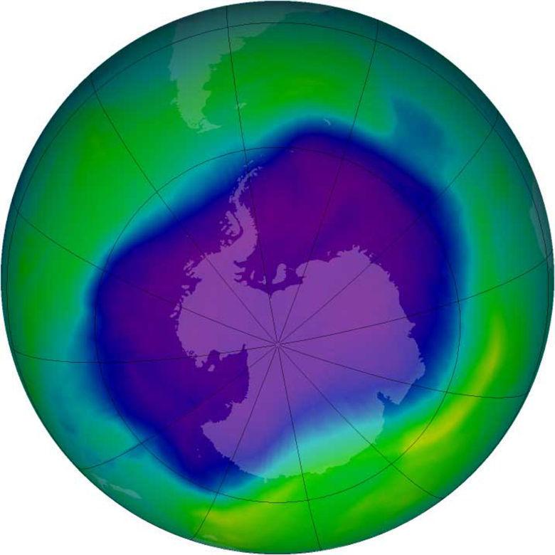
Will there be a White Christmas in Madison this year?

Climatological probability of a “White Christmas” across the contiguous United States.
(Data from NOAA)

In testimony to the infectious appeal of the famous scenes memorialized by Nathaniel Currier and James Ives, prolific lithographers of the middle 19th century, there is an enduring obsession with snow at Christmastime.

A so-called White Christmas is officially observed anytime there is 1 inch of snow on the ground on Christmas morning, whether or not it is snowing at the time.

On average, Madison experiences such a holiday only slightly more than 40 percent of the time. We have had memorably wintry Christmases in the relatively recent past, however. The morning low temperature on December 25, 2000, was a record -21 F with nearly 20 inches of snow on the ground, capping a remarkably snowy month of December that year.

On the other hand, on Christmas Day 1982 the temperature soared to a record high of 56 F with, of course, no snow except at the back door of ice rinks. The next year the minimum temperature on Dec. 25 was a balmy 45 F.

This year it is looking very unlikely that we will record a White Christmas. In fact, thus far in December, our climatologically snowiest month of the year, we have received 1 inch — well behind pace.

Meanwhile, places such as North Carolina and St. Louis have already received their first major storms of the year.

For those of us who are feeling the snow drought more acutely than others, there is some cause for hope. Medium range forecast models are currently suggesting the last week of December may be our first snowy week with a chance of light snow on more than a few of those days.

Steve Ackerman and Jonathan Martin, professors in the UW-Madison Department of Atmospheric and Oceanic Sciences, are guests on WHA radio (970 AM) at 11:45 a.m. the last Monday of each month.


Category: Climate, Meteorology, Seasons

Comments Off on Will there be a White Christmas in Madison this year?

How are clouds named?

This uncommonly clear view of an entire thunderstorm cell, with the top of the growing cumulonimbus tower topping out at 40,000 feet, reveals many interesting features, including “fall streaks” of what may be hail from the underside of the overhanging anvil portion of the cloud. Shortly after this photo was taken on May 22, 2011, near Madison, the storm pelted the Sun Prairie area with large, damaging hail. (Photo credit: Grant Petty, faculty, Department of Atmospheric and Oceanic Sciences, Winner: 2012 Cool Science Image contest)

In 1803, British pharmacist and chemist Luke Howard devised a classification system for clouds. It has proved so successful that meteorologists have used Howard’s system ever since, with minor modifications.

According to his system, clouds are given Latin names corresponding to their appearance — layered or convective— and their altitude. Clouds are also categorized based on whether they are precipitating.

Layered clouds are much wider than they are tall. They generally have flat bases and tops and can extend from horizon to horizon. The Latin word stratus describes the layered cloud category.

Convective clouds are as tall, or taller, than they are wide. These clouds look lumpy and piled up, like a cauliflower. Convective cloud types are indicated by the root word cumulo, which means “heap” in Latin. Convective clouds may become very tall and are rounded on top.

Their altitude and their ability to create precipitation also classify clouds. The root word cirro (meaning “curl”) describes a high cloud that is usually composed of ice crystals which accounts for their wispy appearance. The Latin word alto (“high”) indicates a cloud in the middle of the troposphere that is below the high cirro-type clouds. The prefix or suffix nimbus (“rain”) denotes a cloud that is causing precipitation.

Using the combination of appearance, altitude and ability to make precipitation, a wide range of cloud types can be identified. The 10 basic cloud types are cirrus, cirrostratus, cirrocumulus, altostratus, altocumulus, cumulus, stratus, stratocumulus, nimbostratus and cumulonimbus.

Category: Meteorology, Phenomena

Comments Off on How are clouds named?

How is the atmosphere retained above the Earth?

Earth’s atmosphere and moon from July, 2011.
(Photo credit: ISS Crew / Johnson Space Center)

The atmosphere is actually a fluid. Like water, the pressure at the bottom of a deep column of fluid is larger than the pressure near the top of the column.

Fluids move in response to differences in pressure (the pressure gradient force), always flowing from high toward low pressure. In fact, the wind is driven by pressure differences measured in the horizontal directions. Therefore, the air near the ground (at the bottom of the deep atmosphere) is compelled to move upward toward lower pressure above.

The second fact is that the solid Earth is much more massive than the atmosphere above it which gives rise to the Earth’s gravitational force. Luckily, the force of gravity works in exactly the opposite direction, compelling the air toward the center of the Earth.

To near precision under most conditions, these two forces — the upward-directed pressure gradient force and the downward-directed gravitational force — are balanced, leaving the atmosphere in place surrounding the solid Earth. This important balance is known as the hydrostatic balance.

So, next time you are grateful you are surrounded by an ocean of air, thank the hydrostatic balance.

Category: Meteorology, Phenomena

Comments Off on How is the atmosphere retained above the Earth?

What does the recent cold and snow say about climate change?

It has been quite a week for discussion of global warming.

November has been remarkably cold this year for most of the eastern United States.

In Madison, as just one example, the monthly temperature through Friday has been 6.2 degrees Fahrenheit below normal for the month and, with the prospect of more cold to come, it appears the month will end well below normal.

President Donald Trump, taking note of the near-record cold that was expected for the Thanksgiving holiday, wondered, “Whatever happened to Global Warming?”

Then, on the day after the holiday, the National Climate Assessment, written before the hurricane season and the California wildfires, was released by the Trump Administration answering his question — it continues.

The report synthesizes more than 1,000 peer-reviewed studies regarding the state of the climate and our growing understanding of the issue.

Among the many important statements made in the report, it says that weather extremes associated with the warming climate “have already become more frequent, intense, widespread or of long duration.”

It also reports that over the last decade or so high impact weather has delivered nearly $400 billion dollars in damage to the country, far outpacing any prior records of destruction.

The bottom line is that scientists have reached solid conclusions regarding the threat that climate change poses to our nation, its infrastructure and the quality of life of our fellow citizens.

America has always risen to urgent challenges and met them with courage and eventual success. It is time we turned that indomitable resolve toward this existential problem.

Category: Climate, Seasons

Comments Off on What does the recent cold and snow say about climate change?

What is El Niño and does it affect Wisconsin?

Sea surface temperature anomalies.

El Niño is a combined atmosphere/ocean circulation anomaly in the tropical Pacific Ocean in which unusually warm surface water extends westward from the coast of Peru into the mid-Pacific. One is predicted to develop this winter, which may impact our winter weather.

The warmer than normal waters support persistent tropical thunderstorms in that same region — where such storms are ordinarily rare.

Because the Earth spins on its axis like a merry-go-round, air near the equator (like the outer edge of the merry-go-round) has higher momentum than air at, say, 30 degrees north latitude.

Thus, if equatorial air can be exported to higher latitudes, large wind speeds can be produced at those latitudes. At the top of the thunderstorms, air with high momentum is exhausted into the upper atmosphere and heads north to alter the position of the jet stream. That alteration of the jet stream position and strength tends to make us warmer in the winter.

So unusually warm waters lead to persistent thunderstorms in the eastern equatorial Pacific that alter the position of the jet stream and contribute to unusual winter weather conditions for us. The downstream impact of the altered jet stream is a winter in Wisconsin with less snowfall than normal.

El Niño conditions lead to above-average winter precipitation across the southern United States, and lower than normal snowfall in the northwest U.S. The shift in the position of the jet stream drives winter storms across the southern U.S., leading to above-normal snowfall there and less snowfall in the northern regions of the U.S.

The forecast challenge for winter conditions is that an El Niño doesn’t guarantee a given snow or temperature pattern; it just makes it likely that we will have a milder winter.

Steve Ackerman and Jonathan Martin, professors in the UW-Madison Department of Atmospheric and Oceanic Sciences, are guests on WHA radio (970 AM) at 11:45 a.m. the last Monday of each month.
Category: Meteorology, Phenomena, Seasons

Comments Off on What is El Niño and does it affect Wisconsin?