Why are there so few hurricanes every year?

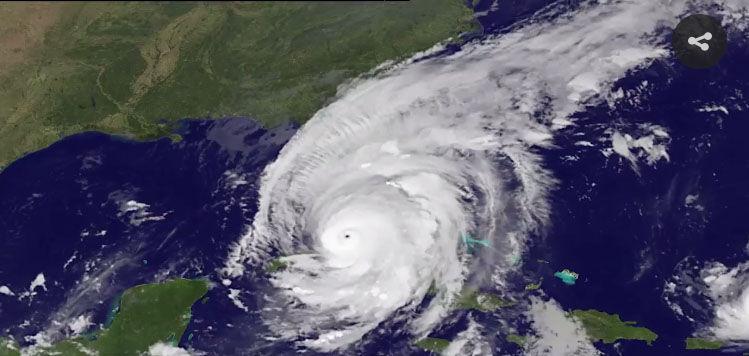
This satellite image from the National Oceanic and Atmospheric Atmospheric Administration shows Hurricane Irma obscuring most of Florida in 2017. Even in a particularly active year, not many hurricanes actually develop. (Photo credit: NOAA)

We are about five weeks away from the climatological peak of the hurricane season, which stretches from early June to November.

During that period, even in a particularly active year, not many hurricanes actually develop. Forming over tropical oceans ensures that warm sea-surface temperature (SST) provides a mature hurricane with a means to warm and moisten the air that flows toward the important eye-wall convection. Thus, it is not surprising that hurricanes struggle to develop if the SST is not 79.7 degrees or warmer.

Tropical cyclones also require environments in which the wind speed and direction changes very little with increasing height, or where the vertical wind shear is small.

Certain vast stretches of the tropical ocean have SSTs above the threshold value of 79.7 degrees and thus qualify as locations where the development of tropical cyclones is favored. However, within such areas, it is only when the vertical shear is very low — from the surface to about 8 miles above the surface — that hurricanes can form and grow to maturity. In a given location in the tropics, it is much more likely that the shear condition, not the SST, will vary from one day to the next.

There are a number of physical factors that can conspire to render the vertical shear too extreme to allow for hurricane development. One such factor is the presence of the so-called subtropical jet stream, which is located between 20 degrees and 30 degrees latitude and about 8 miles above the ground in both hemispheres.

The subtropical jet stream is an ever-present feature of the general circulation of the tropics and has wind speeds routinely in excess of 130 mph. Such strong winds well above the surface are more than sufficient to provide a toxic amount of vertical shear to a nascent tropical cyclone. The small number of hurricanes every year testifies to the hostility of the environment to their development.

Category: Severe Weather, Tropical

Comments Off on Why are there so few hurricanes every year?

What is with the hot temperatures in Europe?

Temperature anomalies across Europe (departures from normal) measured by satellite in late June.

Europe recorded its hottest June ever.

The hottest temperatures occurred June 26-28, resulting from a high-pressure system that settled over Europe combined with hot winds from the Sahara Desert in Africa. France observed temperatures in excess of 113 degrees for the first time since temperatures were recorded.

The global average temperature of June 2019 was the highest measure for the month of June in the 140-year National Oceanic Atmospheric Administration (NOAA) global temperature record. The NOAA measurements also show that the January-June temperature for 2019 is the second-warmest January-June on record.

Europe is on its way to recording one of the hottest Julys on record also. The June heat wave was followed by another heat wave at the end of July. Five countries set new all-time national heat records. The Netherlands, Belgium, United Kingdom, Luxembourg and Germany reached new temperature records of 102.7, 107.2, 100.6, 105.4 and 108.7, respectively. The new records in Belgium and Luxembourg exceeded the old records by more than 5 degrees. Last week Germany, France and Belgium each saw record-breaking temperatures at cities throughout the country, beating record temperatures set in the 1940s.

The high temperatures can cause various materials to expand, causing travel problems for commuters and holiday travelers. The high temperatures affect road conditions. Expanding concrete doesn’t have enough room to expand and can buckle. Or, slabs can push against one another and crack. Under hot conditions, tarmac can melt.

The hot weather can lead to cancellations or delay of trains, as the heat can cause train tracks to buckle or signals to fail. Hundreds of Eurostar passengers from Brussels to London were stuck for hours in 104-degree heat when their train broke down in a tunnel.

Steve Ackerman and Jonathan Martin, professors in the UW-Madison Department of Atmospheric and Oceanic Sciences, are guests on WHA radio (970 AM) at 11:45 a.m. the last Monday of each month.
Category: Meteorology, Weather Dangers

Comments Off on What is with the hot temperatures in Europe?

Did the moon landing influence weather forecasting?

Astronaut Buzz Aldrin Jr. stands next to the Passive Seismic Experiment device on the surface of the moon on July 20, 1969, during the Apollo 11 mission. The space race was responsible for enormous advances in satellite technology. (Photo credit: Neil Armstrong)

On Saturday, we will mark the 50th anniversary of humankind’s first-ever footsteps on a different world, the lunar landing of Apollo 11.

The moon landing represented the peak of the Cold War’s space race and, though motivated by martial competition between geopolitical adversaries, the drive to reach the moon produced a large number of technical advances which most of us take for granted today.

With specific respect to weather forecasting, the space race was responsible for enormous advances in satellite technology that now provide the backbone of the global observations of the atmosphere required to power the weather prediction enterprise.

Another extremely important aspect of the prediction revolution was the rapid development of computer technology. Despite the fact that your mobile phone has more computing power than the entire array of machines available to Mission Control in July 1969, the Apollo program drove the development of smaller and more powerful computers.

Finally, the Apollo program provided inspiration to thousands of young boys and girls who were fortunate enough to see, at an early age, what science really is — a grand adventure of exploration and discovery. One of us (Martin), still retains vivid memories of making the first footprints in the newly fallen snow of a New England blizzard while delivering morning newspapers and imagining himself as Neil Armstrong. That sense of kinship with a hero of exploration likely fueled more than one young person’s desire to pursue the wonders of science.

Category: Climate, Meteorology

Comments Off on Did the moon landing influence weather forecasting?

Can large cities generate their own weather?

The “urban heat island effect” refers to the increased temperatures of urban areas compared with their rural surroundings.

The urban heat island is a well-documented example of inadvertent modification of climate by human activities. It is a classic example of how changing the energy balance of an area can affect the regional climate.

The urban heat island is evident in statistical analysis of surface air temperatures, and was first discovered in the early 1800s in London.

On average, a city is warmer than the countryside because of differences between the energy gains and losses of each region. A number of factors can contribute to the relative warmth of cities, such as heat from industrial activity, the thermal properties of buildings, and the evaporation of water.

Heat produced by heating and cooling city buildings and running planes, trains, buses and automobiles contributes to the warmer city temperatures. Asphalt, brick and concrete retain heat better than do natural surfaces.

Evaporation of water plays a role in defining the magnitude of the urban heat island. Solar energy absorbed near the ground in rural areas evaporates water from the vegetation and soil. Thus, heating in the rural areas is reduced to some degree by evaporative cooling during evapotranspiration.

Megacities tend to have up to 10 percent more cloud cover than surrounding rural areas. (Photo: Pixabay)

A recent study of clouds over London and Paris using satellite data indicates that cities may be generating clouds. During the spring and summer, these megacities are persistently cloudier in the afternoon and evening than nearby rural areas. The authors suggest that the heat retained by buildings drives motions that lead to cloud formation.

Meteorologists have thought that regions downwind of large cities receive more than their expected share of rainfall; however, conclusive evidence has been hard to gather.

Steve Ackerman and Jonathan Martin, professors in the UW-Madison Department of Atmospheric and Oceanic Sciences, are guests on WHA radio (970 AM) at 11:45 a.m. the last Monday of each month.
Category: Meteorology, Phenomena

Comments Off on Can large cities generate their own weather?

Has this been an unusually dreary spring?

From April 1 to June 13, Madison Wisconsin was 0.46 degrees cooler than  normal and accumulated 1.94 inches above normal precipitation, some falling as snow as late as April 27!
(Photo by J. Hart, State Journal archives)

With astronomical summer set to begin on Friday morning at 10:54 a.m. in Wisconsin, it seems like a good time to consider the nature of this seemingly dreary and cold spring that we have just endured.

Almost no one will disagree that this year has had a memorably bad spring, not only locally but around the nation as widespread flooding has put elements of the agricultural sector well behind their normal schedules.

From April 1 to June 13 we have averaged 0.46 degrees below normal in Madison and we have accumulated 1.94 inches above normal of liquid equivalent precipitation, some of it falling as snow as late as April 27.

In the previous four springs we have had similar experiences only once. Some may recall that last April 1 through June 13 we were 0.36 degrees colder than normal and accumulated nearly 7 inches of snow on April 18. In the prior three years during the same period we averaged 1.94, 0.71 and 2.19 degrees above normal. None of these years was notably warm during the period but these recent records do suggest that this year presents a relatively unusual set of circumstances.

In fact, it may be that we have not had such a persistently cool spring since 1997 when April was 3.3 degrees below normal, May was 6 degrees below normal and the first 13 days of June averaged 1.75 degrees below normal, leading to an overall departure of 4.16 degrees below normal for the same period in that year.

So, though we have been waiting for spring to transition to summer, we had it much worse 22 years ago.

Category: Climate, Meteorology, Seasons

Comments Off on Has this been an unusually dreary spring?