Did Madison break any snowfall records last month?

As we begin Winter Weather Awareness week in Wisconsin (Nov. 4-8), too many of us probably feel like grizzled veterans already.

What an end to the month of October!

It was a chilly month overall, with the average temperature ending up 1.5 degrees F below normal. This chill was especially notable in the last 10 days of the month, which averaged 6.7 degrees F below normal and were attended by a record setting 8.1 inches of snow in nearly back-to-back, but separate, events on Oct. 28-29 and Oct. 30-31.

The 8.1 inches of snow set the all-time monthly record for Madison, shattering the old record of 5.2 inches set more than a century ago in 1917.

The single storm total of 5.1 inches from the second of the two snowfalls also broke the previous record of 3.8 inches for a single storm set on Oct. 26-27, 1997.

Shoveling snow on Halloween in Madison revealed Autumn leaves below.
Image credit: M. Mooney

Finally, the 4 inches of snowfall on Halloween became the earliest 4 inches or greater snowfall in Madison’s history, displacing the prior record set on Nov. 3, 1951.

The fact that nearly 70 years have elapsed since such an early 4 inches of snowfall suggests that we are at the very limit of how early such an accumulation can occur in Madison.

Given that our average first inch of snow falls here on Nov. 27, we are nearly a full month ahead of schedule.

Finally, with 1 inch of snow on Oct. 28, this year contained Madison’s second-shortest interval between 1 inch or greater snowfalls on the bookends of summer (April 27 to Oct. 28).

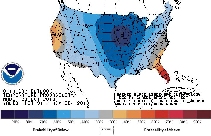
It is tempting to wonder if this week’s early snow portends anything about the coming winter. Our strong suspicion is that the answer is no — but don’t let that dim your enthusiasm for what was a truly astounding, record-setting week.

Steve Ackerman and Jonathan Martin, professors in the UW-Madison Department of Atmospheric and Oceanic Sciences, are guests on WHA radio (970 AM) at 11:45 a.m. the last Monday of each month.
Category: Meteorology, Seasons

Comments Off on Did Madison break any snowfall records last month?

What are the chances for a snowy Halloween?

The last half of October has been a bit cooler than normal, and there is a real chance we will see our first accumulating snow of the season this week.

Overall, the chances for snow are relatively slim in October — only one in 10 Octobers has a day with more than 1 inch of snowfall.

Many of us recall that last Oct. 20 we had a period of moderate snow that dusted the ground for a short time in the afternoon.

Because the ground is still usually very warm at this time of year, much of the snow that falls in October does not stick around, and even on the snowiest October day in the past 80 years (Oct. 26, 1997, when 3.8 inches of snow fell at the Madison airport) very little remained on the ground during the next couple of days.

Starting tonight, it appears that we may have snow in the air for a good part of the week, at least on an intermittent basis.

It is unlikely that we will see accumulating snow, but it is not impossible that trick-or-treaters will be dodging snowflakes Thursday night.

Current medium-range forecast models suggest a more substantial threat of accumulating snow coming at the end of the weekend.

Even if that threat turns out to be exaggerated, it does look likely that the end of this month and the beginning of the next will be colder than normal. Thus, it is safe to say that early winter has arrived.

Steve Ackerman and Jonathan Martin, professors in the UW-Madison Department of Atmospheric and Oceanic Sciences, are guests on WHA radio (970 AM) at 11:45 a.m. the last Monday of each month.
Category: Meteorology, Seasons

Comments Off on What are the chances for a snowy Halloween?

Why has October been so stormy?

Thus far, October 2019 has been an active weather month over North America.

The month began with a week-long period of moderate to heavy rain over the Great Lakes states associated with an energetic jet stream racing across the northern tier of states.

Near the end of the second week of the month, a major cyclone developed over the High Plains triggering a series of high-impact weather events across a large part of the nation.

The first substantial snows of the season struck Denver and other cities in the Intermountain West, and as the storm moved eastward, it dropped as much as 30 inches of snow in central North Dakota.

Farther to the west, surface high pressure built inland leading to strong Santa Ana winds over central and southern California triggering a number of destructive wildfires.

In Denver, the storm’s passage dropped the temperature from 83 on Oct. 9 to 13 by the end of the next day. That was the fourth largest one-day temperature drop since record keeping began in Denver in 1872.

Late last week a major cyclone struck the northeastern U.S. with heavy rains and hurricane-like winds. Boston had peak wind gusts of 55 mph with some locations in coastal Maine howling up to 80 mph. The storm brought down trees and power lines in a vast number of communities in eastern New England and snarled air travel for several days.

Such high-impact events are characteristic of October — a unique month for the large-scale circulation of the Northern Hemisphere.

During October the decreasing daylight cools the high latitudes and energizes the polar jet stream.

Meanwhile, the last tropical cyclones of the season ensure that the year’s most energetic interaction between the tropics and the mid-latitudes occurs then.

Such interactions can have an enormous impact on the development of weather systems in the middle latitudes at this time, leading to a parade of high-impact events like the one that just visited North America.

Steve Ackerman and Jonathan Martin, professors in the UW-Madison Department of Atmospheric and Oceanic Sciences, are guests on WHA radio (970 AM) at 11:45 a.m. the last Monday of each month.
Category: Meteorology, Seasons

Comments Off on Why has October been so stormy?

Why does the rate for change of day length vary?

A youngster in a kayak makes a picturesque journey to shore at sunset on Beaver Dam Lake. (Photo credit: Kelly Simon, Beaver Dam
Daily Citizen)

We define the length of the day as the time between sunrise and sunset, so that we can apply some simple mathematics.

Atmospheric conditions can make the actual sunrise and sunset vary slightly from the calculated times. As the Earth moves around the Sun, the length of the day changes.

The length of day at a particular location on Earth is a periodic function of time. This is all caused by the 23.5-degree tilt of the Earth’s axis as it travels around the sun. In the Northern Hemisphere, days are longest at the time of the summer solstice in June, and the shortest days are at the winter solstice in December. At the two equinoxes in March and September, the length of the day is about 12 hours, a mean value for the year.

The length of a day changes far more during the year at higher latitudes than at lower latitudes. At the poles the daytime length varies from 0 to 24 hours, while at the tropics the daytime length varies little.

There is essentially no change in length of day from one day to the next at the time of the solstices. There is more change at the equinoxes. At those times the day-to-day changes can be a few minutes. The day length is changing fastest at the equinoxes.

Consider the percentage change — the change in day length from the previous day divided by the length of day on that day. That can give the impression of how quickly we lose daylight.

The shortening of the length of day in terms of percentage change is at its peak in late October and early November around our latitude.

Category: Meteorology, Seasons

Comments Off on Why does the rate for change of day length vary?

Why should we be concerned about the Arctic climate?

Researchers look out from the Finnish icebreaker MSV Nordica as the sun sets over sea ice in the Victoria Strait along the Northwest Passage in the Canadian Arctic Archipelago. The occasional extreme late-summer storm can be quite damaging to the ice. (Photo credit: David Goldman, Associated Press)

Changes in the Arctic have global implications. The global average temperature is warming but the air temperatures in the Arctic are increasing twice as fast or possibly faster.

The year 2019 will go down as the second-lowest minimum extent of sea ice. Sea ice is bright and reflects about 80% of the sunlight that falls on it, helping to keep the surface cold.

When the sea ice melts, the ocean surface is exposed and absorbs incident solar energy. That leads to a warming of the water and the air above, which melts more ice, leading to increased warming and more melting.

Arctic sea ice is now less than half as thick as it was at this time of year in 1980.

The Arctic permafrost is thawing, releasing carbon and methane that has been frozen in the earth for millennia. Release of these two greenhouse gases into the atmosphere causes further warming. The ground can collapse when permafrost laced with ice melts, weakening structures built on the surface.

Global wind patterns are driven by the temperature difference between the equator and the polar regions.

The quicker warming of the Arctic reduces this temperature difference, which can change global wind patterns.

The melting of ice over Greenland reached historically high levels in 2019 when wind patterns transported warm air from Europe’s midsummer heat wave. The rapid melting removed the previous winter’s low snowfall and exposed older ice. The older ice is not as bright as the fresh snow and increases absorption of solar energy thereby increasing the melting.

The Greenland ice sheet is the world’s second-largest repository of freshwater. As the ice melts, it enters the oceans and can raise global sea levels. Current trends are heading to sea level rise of 6 to 12 inches worldwide this century.

Indigenous populations are also affected. The reduction of frozen areas affects the cultural practices of the Arctic peoples developed through their centuries-old finely honed relationship with the land, ocean and ecosystems.

Category: Climate, Meteorology

Comments Off on Why should we be concerned about the Arctic climate?