Why does my home seem so dry in cold weather?

The amount of moisture in the air, which is the humidity, is a very important aspect of weather.

There are a few ways to express the amount of water vapor in the atmosphere. Each way has advantages and disadvantages. Two of the more common are the dew point and the relative humidity.

The dew point is the temperature to which air must be cooled to become saturated with water vapor, assuming constant air pressure and water content. Dew forms when air is cooled to the dew point temperature.

Try online activity explaining the relationship between the thermostat setting in your house and the outdoor temperature and dew point: go.madison.com/dewpoint

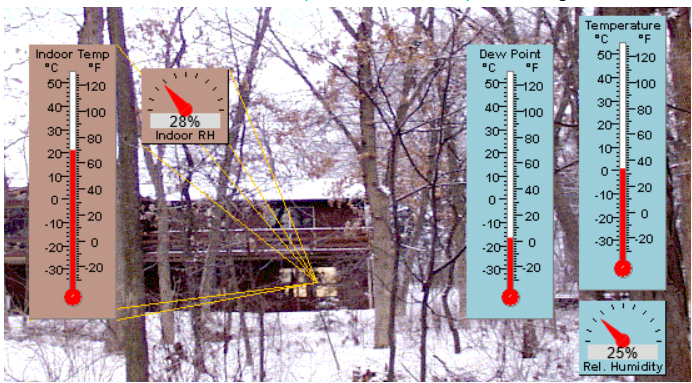
The relative humidity is a percentage, defined as the ratio of the actual amount of water vapor in the air to the maximum amount of water vapor the air can hold. The maximum amount is a function of temperature. When the dew point temperature equals the air temperature, the relative humidity is 100% and the air is considered saturated with water vapor. The larger the difference between the dew point and the temperature, the lower the relative humidity. Cold outside air entering your home is heated by your furnace; this increases the temperature but not the dew point. This leads to a drop in relative humidity in your house, as the difference between the dew point temperature and the temperature in your home increases. If you want to explore this relationship between the thermostat setting in your house and the outdoor temperature and dew point, try this on-line activity at go.madison.com/dewpoint.

When the dew point is too low, your skin may dry out and feel itchy. Also, static electricity in your home may increase. This can cause clothes to stick together and for you to feel shocks when you touch something. Humidifiers add water molecules to the air, which increases the dew point temperature. That can result in a higher relative humidity.

Steve Ackerman and Jonathan Martin, professors in the UW-Madison department of atmospheric and oceanic sciences, are guests on WHA radio (970 AM) at 11:45 a.m. the last Monday of each month. Send them your questions at stevea@ssec.wisc.edu or jemarti1@wisc.edu.

Category: Meteorology, Seasons

Comments Off on Why does my home seem so dry in cold weather?

How does this winter measure up so far?

NOAA’s Climate Prediction Center’s 3-month outlook depicting the most likely temperature outcome. (Credit: NOAA/CPC)

Two of the more popular (and telling) measures of the severity of a winter are extremes of cold and the presence of snow.

One reasonable way to consider extremes of cold might be to count the number of mornings on which the temperature drops below zero. So far this winter (defined as beginning on Dec. 1), we have had just five such mornings here in Madison.

It turns out, over the last 30 winters (back to 1992-93), Madison has averaged 5.97 such mornings through Jan. 17. So, it might seem that we are pretty normal by this measure, though the variability of below-zero mornings is quite large.

Six of the last 30 years have had no such days, while five have had 13 or more — the winner is 2000-01, when 19 such frosty mornings graced Madison, 14 of them in an incredibly wintry December.

However, our average temperature since Dec. 1 is about 2.7 degrees above average — quite warm for the first half of meteorological winter. Our snow situation has been unimpressive so far, as we have had only two days on which 1 inch or more of snow has fallen. The biggest snowfall occurred on Dec. 28, when 3.3 inches fell, and our snow depth has varied between 3 and 4 inches ever since, accounting for the wintry look we have all experienced for the past two weeks plus.

With only a couple of rather light snows in the forecast for the next couple of weeks — though that is subject to change — our snow situation might remain paltry through the end of January. So far, not a very memorable winter.

Steve Ackerman and Jonathan Martin, professors in the UW-Madison department of atmospheric and oceanic sciences, are guests on WHA radio (970 AM) at 11:45 a.m. the last Monday of each month. Send them your questions at stevea@ssec.wisc.edu or jemarti1@wisc.edu.

Category: Climate, Meteorology, Seasons

Comments Off on How does this winter measure up so far?

Is permafrost permanent?

 Non-summer season CO2 flux rates for the permafrost region, synthesized from individual study sites measured between 2003 and 2017 and extrapolated using environmental variables. (Image credit: Ted Schnuur, NOAA Arctic Program)

Permafrost is ground that has a temperature below freezing for at least two consecutive years.

Permafrost varies in thickness from less than a couple of feet to more than 4,000 feet thick. Permafrost is mostly located in polar regions, although it also occurs in some high mountains where it is called alpine permafrost. Much of the permafrost in Alaska is tens of thousands of years old.

Permafrost near the surface contains plant material that has not yet completely decomposed. During photosynthesis, plants pull carbon dioxide out of the atmosphere. When they die, or when they drop their leaves in fall, the plant material decomposes and returns the carbon dioxide into the atmosphere. In the Arctic, plants grow slowly and they also decompose slowly as plant material freezes and becomes part of the permafrost.

The carbon in the plant is stored in the permafrost, and after many centuries the result is that there is a lot of carbon stored in the permafrost. It is estimated that the amount of carbon frozen in the permafrost is more than two times the amount of carbon currently in our atmosphere.

The Arctic is warming faster than anywhere else on the planet, and its permafrost is starting to thaw. One-fifth of frozen soils in the Arctic are thawing rapidly, and that is a concern for enhancing the existing global warming. As the ground thaws, the microbial activity increases and the plant material currently frozen in the permafrost will decompose, adding carbon dioxide into the atmosphere. The thawing that is being observed will enhance global warming by adding carbon.

Some villages in the Arctic are built on permafrost. Permafrost is harder than concrete when frozen; however, the soil loosens as it thaws. Buildings, homes, roads and other infrastructure get damaged as the permafrost thaws and weakens.

Steve Ackerman and Jonathan Martin, professors in the UW-Madison department of atmospheric and oceanic sciences, are guests on WHA radio (970 AM) at 11:45 a.m. the last Monday of each month. Send them your questions at stevea@ssec.wisc.edu or jemarti1@wisc.edu.

Category: Climate, History

Comments Off on Is permafrost permanent?

How common are extreme winds in the Front Range of the Rocky Mountains?

This winter has already delivered some notable disasters, and it is important to carefully consider the anatomy of such high impact weather events in order to, as accurately as possible, understand to what degree an event is attributable to the background climate change.

The frightening wildfire in Boulder County, Colorado, on Thursday was a conspiracy of somewhat routine and unusual circumstances. So-called “Front Range windstorms” occur in some degree nearly every year in the immediate lee of the Rockies in Colorado and, though they are not exclusively a wintertime phenomena, they are much more common in the cold season. A comprehensive list of such events dating back to the winter of 1966-67, with a host of additional statistics regarding the actual events, is available at go.madison.com/boulder.

Last week’s event made national news because it was coupled with wildfires enabled by the notable drought that has plagued the Front Range throughout the fall and early winter. A number of locations reported wind gusts up to 115 mph, which propelled the fire forward at nearly the speed of the wind since the grasses that conveyed the flames were so unusually dry. As is widely known now, a large number of homes in the Boulder area were consumed by these flames and thousands of people were forced to hastily evacuate with little notice.

A burned truck in a destroyed neighborhood in Louisville, CO is covered with snow just days after the wildfire. Credit: Thomas Peipert, Associated Press

As if to add insult to substantial injury, Friday evening into Saturday, the region received a substantial snowfall — sufficient, had it happened on Wednesday, to have completely suppressed the fire threat.

The drought contribution to this event might have a link to the changing climate — the high winds, however, almost certainly do not.

Steve Ackerman and Jonathan Martin, professors in the UW-Madison Department of Atmospheric and Oceanic Sciences (AOS, are guests on WHA radio (970 AM) at 11:45 a.m. the last Monday of each month and authors of a weekly weather artcle in the Wisconsin State Journal.

Category: Meteorology, Phenomena, Weather Dangers

Comments Off on How common are extreme winds in the Front Range of the Rocky Mountains?

What is the winter solstice?

The Earth makes a complete revolution around the sun once every 365 days, following an orbit that is elliptical in shape.  This means that the distance between the Earth and Sun, which is 93 million miles on average, varies throughout the year.  Seasons are caused by the fact that the Earth is tilted on its axis by 23.5°.  The tilt’s orientation with respect to space does not change during the year; thus, the Northern Hemisphere is tilted toward the sun in June and away from the sun in December, (Image credit: weather.gov)

The winter solstice (In Latin, sol, “sun,” and stice, “come to a stop”) is the day of the year with the fewest hours of daylight in the Northern Hemisphere.

In 2021, this occurs for the Northern Hemisphere on Dec. 21 at 9:59 a.m.

As Earth orbits the sun, its axis of rotation is tilted at an angle of 23.5 degrees from its orbital plane. Because Earth’s axis of spin always points in the same direction — toward the North Star — the orientation of Earth’s axis to the sun is always changing as Earth orbits around the sun.

As this orientation changes throughout the year, so does the distribution of sunlight on Earth’s surface at any given latitude. This links the amount of solar energy reaching a location to the time of year and causes some months of the year to always be warmer than others — in other words, the seasons.

On the Northern Hemisphere’s winter solstice, the northern spin axis is pointed away from the sun and latitudes north of the Arctic Circle (66.5 degrees North) have 24 hours of darkness. Meanwhile, the Southern Hemisphere is having short nights and long days.

The time of day that the sun reaches its highest point in its journey across the sky is called solar noon. In early December, true solar noon comes nearly 10 minutes earlier by the clock than it does at the solstice. With true noon coming later on the solstice, so will the sunrise and sunset times.

This discrepancy between clock time and solar time causes the Northern Hemisphere’s earliest sunset to precede the December solstice. The precise date of the earliest sunset depends on your latitude. The latest sunrise doesn’t come on the solstice either. From mid-northern latitudes, the latest sunrise comes in early January.

After the winter solstice, the days get longer, very slowly at first, but at ever larger daily intervals as the March equinox approaches, marking springtime.

Steve Ackerman and Jonathan Martin, professors in the UW-Madison department of atmospheric and oceanic sciences, are guests on WHA radio (970 AM) at 11:45 a.m. the last Monday of each month. Send them your questions at stevea@ssec.wisc.edu or jemarti1@wisc.edu.

Category: Meteorology, Seasons

Comments Off on What is the winter solstice?