Two of the more popular (and telling) measures of the severity of a winter are extremes of cold and the presence of snow.
One reasonable way to consider extremes of cold might be to count the number of mornings on which the temperature drops below zero. So far this winter (defined as beginning on Dec. 1), we have had just five such mornings here in Madison.
It turns out, over the last 30 winters (back to 1992-93), Madison has averaged 5.97 such mornings through Jan. 17. So, it might seem that we are pretty normal by this measure, though the variability of below-zero mornings is quite large.
Six of the last 30 years have had no such days, while five have had 13 or more — the winner is 2000-01, when 19 such frosty mornings graced Madison, 14 of them in an incredibly wintry December.
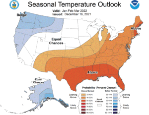
However, our average temperature since Dec. 1 is about 2.7 degrees above average — quite warm for the first half of meteorological winter. Our snow situation has been unimpressive so far, as we have had only two days on which 1 inch or more of snow has fallen. The biggest snowfall occurred on Dec. 28, when 3.3 inches fell, and our snow depth has varied between 3 and 4 inches ever since, accounting for the wintry look we have all experienced for the past two weeks plus.
With only a couple of rather light snows in the forecast for the next couple of weeks — though that is subject to change — our snow situation might remain paltry through the end of January. So far, not a very memorable winter.
Steve Ackerman and Jonathan Martin, professors in the UW-Madison department of atmospheric and oceanic sciences, are guests on WHA radio (970 AM) at 11:45 a.m. the last Monday of each month. Send them your questions at stevea@ssec.wisc.edu or jemarti1@wisc.edu.

