How hard do weather forecasters work?

In the wake of a remarkable, but not perfect, forecast of a paralyzing blizzard that affected the Northeast last week, one may wonder how much effort is expended by an individual forecaster.

Since it takes only a minute or two to deliver a forecast on the evening news, it is easy to mistakenly view the process as taking very little effort or care.

In reality, the short broadcast time is supported by many hours of intense, professional effort divided among a multitude of difficult tasks.

Perhaps first on that list, the forecaster must gain a comprehensive understanding of the current observations throughout the atmosphere and over a large region of the country.

This process alerts her to the features in the atmosphere that will likely have a bearing on tomorrow’s weather in her region. She must then consult the numerical model guidance to incorporate the model forecast information into her evolving sense of what tomorrow will be like.

Then, she likely consults with other learned colleagues — all of whom are constantly putting their hard-won knowledge of how the atmosphere works into practice. Arguing about their separate interpretations of what is coming is among the most challenging and time-consuming aspects of the job.

By this point in the process a forecaster is likely to have spent several hours of preparation time. The forecaster has other duties as well, such as working with authorities to support their decision-making process, answering public questions and working with the producer, as well as administrative tasks.

Thus the final product — the public broadcast of the forecast — is actually only a small part of a much more elaborate and challenging process designed to produce a result with direct relevance to the lives of many thousands of people.  It is hard to judge what a given job really entails on the basis of uninformed assumptions that arise from one’s own limited experience with the nature of the task.

Category: Meteorology, Severe Weather

Comments Off on How hard do weather forecasters work?

Can you explain the difference between black ice and gray ice?

The term ‘black ice’ refers to two conditions: a new layer of ice on water, which appears dark in color because the ice is transparent and so we see the deep water below, or as a layer of clear ice on a roadway, which makes for hazardous driving conditions.

In both cases the ice is not black but transparent, and therefore shows the color of the underlying surface.

The ice is clear because no air bubbles are trapped in the ice.

Lots of trapped air makes an object look white. Snow looks white because of air trapped between crystals.

The danger of driving on a road covered with black ice is that the roadway can appear to be merely wet.

Drivers may not recognize the slippery conditions until it is too late.

Crashes also occur when a roadway freezes over quickly because of freezing rain.

A freezing rain situation occurred in the northeast on Jan. 18, resulting in several multiple vehicle pile-ups and some deaths.

The temperature of the road was below freezing, and when rain fell it quickly froze, resulting in extremely hazardous conditions.

Even walking can be seriously affected on certain days.

Keep in mind that your thermometer placed several feet above the ground may register an above-freezing temperature while the temperature at the surface, where ice can form, may be below freezing.

If a sidewalk is covered with clear ice, it will look dark gray — like a wet sidewalk.

This “gray ice” can be hazardous for walking and undoubtedly contributes to thousands of personal injuries during winter.

Category: Meteorology, Seasons, Weather Dangers

Comments Off on Can you explain the difference between black ice and gray ice?

How unusual is our roller coaster winter?

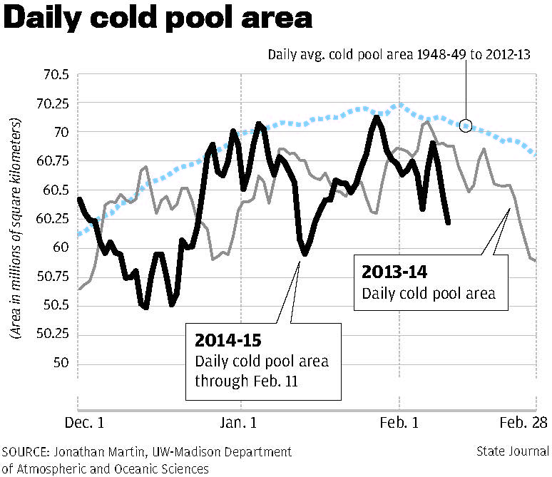
It doesn’t take an exceptional attention span to realize that this year’s cold season (starting in November) has been very changeable.

November was 6.1 degrees colder than normal, then December was surprisingly mild (5.8 degrees above normal). As of Thursday — mid-month — January has been 8.5 degrees below normal.

Thus far we have had only 14.9 inches of snow and every month has been substantially drier than normal as well.

This is shaping up to be a very unusual winter in many respects. After a relative warm up, forecast models are suggesting a return to very cold temperatures as we approach the end of January. We suspect this will be enough to keep the monthly average temperature below the normal for January.

Though there is really no way to accurately forecast the monthly average for February, experimental forecasts made by the Climate Prediction Center, issued Thursday, predict a 50-50 chance for a normal February in Wisconsin.

Though detailed records are not immediately available, anecdotally it has been at least 20 years since a cold season has flipped from below normal to above normal in consecutive months from November to February. There is some chance that this will be such a year.

Category: Climate, Meteorology, Seasons

Comments Off on How unusual is our roller coaster winter?

Are the Great Lakes’ water levels normal?

For the first time in about 25 years, the water level of the all the Great Lakes is above normal. Lakes Superior, Michigan and Huron are about 5 inches above the long term average.

This ends a 15-year period where lake levels have been below historic averages.

Lakes Huron and Michigan were at record low levels in January 2013; that is a rapid rise in water level to be above normal two years later. Such a rapid increase has not been measured since observations began in the mid-1800s.

The water levels of the Great Lakes are determined by the amount of water flowing in and out of the lakes.

Precipitation, runoff, and water from streams and groundwater supply water to the lakes, while evaporation and water flowing out of the Great Lakes system are water losses.

When the input exceeds the output, the levels rise.

The water cycle of the lakes is complex, and weather has played a role in this turnaround in lake levels.

Above-average precipitation and above average runoff in the Great Lakes watershed, particularly in the springs of 2013 and 2014, helped to restore lake levels.

The frigid winter of 2013-2014 also helped by reducing evaporation.

Ice on the lake and cold waters reduce evaporation, which also reduces snowfall in the snow-belt regions of the lakes.

Information on and forecasts of Great Lakes water levels is available from several agencies in the United States and Canada.

The forecast for the water levels is to continue to be above average, though levels could change relatively quickly.

Category: Climate, Meteorology, Seasons

Comments Off on Are the Great Lakes’ water levels normal?

What rare weather event did we experience last month?

Madison’s overnight low temperature of minus 3 on Dec. 28 was a relatively rare event, all things considered.

As we all know, the temperature dipping below zero in winter is not unusual. But it doesn’t usually happen without snow on the ground, and there are good reasons for that.

Snow on the ground works double duty to keep the air near the ground very cold. First, since the ground is a vast storehouse of heat, the presence of snow insulates the air above from that heat.

The fact that snow is an excellent absorber and emitter of infrared energy — the kind of radiation that nearly everything on Earth emits, including the ground — gives this insulation effect an added radiative dimension. With a couple of inches or more of snow cover, the infrared energy emitted by the ground is absorbed by the overlying snow.

The snow then emits that energy in all directions, some of which are back toward the underlying ground. Thus, much less than half of the energy that would otherwise be emitted from the ground to the overlying atmosphere never gets there.

Secondly, since the top surface of the snow is emitting infrared exceptionally well, the air in contact with that snow surface can get really, really cold. The result is extremely cold surface air.

In our last cold spell, the coldness was imported from locations where this radiative cooling had been in operation — places to our north. This coming week, our low temperatures will be partly “home-brewed” by the snow we just received.

Category: Meteorology, Seasons

Comments Off on What rare weather event did we experience last month?