What caused the recent weather extremes?

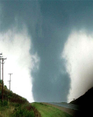
The National Weather Service in Milwaukee confirms that three separate tornadoes occurred in our state on Tuesday.

EF-1 tornadoes, with winds estimated at up to 110 mph, struck Lake Geneva and a location just outside of Big Bend. An EF-0 tornado, with winds estimated at up to 80 mph, struck southwest Waukesha.

These storms occurred at the end of the most prolonged heat wave of the summer. From Aug. 14-16, we had high temperatures in Madison of 92, 91, and 88, respectively – marking the only time yet this summer where we had consecutive days above 90.

By Wednesday, our high temperature was only 70 — our lowest high since July 8 — and the weather had turned astonishingly autumnal.

What was responsible for the fairly rapid fall of temperature? The first fall-like cyclone of the year raced across the Great Lakes states Tuesday night and Wednesday dragging the first fall-like cold front along with it. Behind the front the air is substantially colder and, perhaps most noticeably, much drier. At this time of year, the path along which such storms progress from west to east, the so-called storm track, begins to migrate southward as the northern latitudes cool in response to diminished daylight.

The good news, for now, is that the return of southerly winds and warmer temperatures is also quick when the storm track is right over Wisconsin. Later in the fall and winter, when the storm track is well to our south, the passage of storms leaves us in the cold air for much longer.

Category: Meteorology, Seasons, Severe Weather

Comments Off on What caused the recent weather extremes?

Are presidential candidates’ views on climate change correct?

The observational evidence that the Earth is warming is overwhelming and unmistakable.

Surface observations of temperature over land and ocean have shown that all but one of the 15 warmest years on record have occurred since 2000.  the average length of the ice season on a collection of widely distributed Northern Hemisphere lakes, each with at least 150 years of continuous record, has decreased by over two weeks.  The areal extent of the Northern Hemisphere’s wintertime cold pool has systematically shrunk in the last two winters recording the smallest seasonal average cold pool areas since records began in 1948-1949.

Lurking behind the curtain on all of these observations of warming and its effects is the additional observation that the carbon dioxide fraction in the atmosphere – which has a well understood physical relationship to global physical temperature – has grown to levels not seen in at least the last 800,000 years.  This increase is demonstrably related to the combustion of carbon-based fossil fuels, a global business enterprise in which careful accounting of the extraction, sale and use of this valuable commodity leaves no ambiguity about the amount of CO2 that has been added to the atmosphere through its usage.

In spite of this clear evidence, only one of the Republicans seeking the nomination for president, Sen. Lindsey Graham, unequivocally accepts the scientific consensus on this issue.

Sen. Ted Cruz accuses scientists of “cooking the books” while asserting no warming has occurred over the past two decades.  Our own Gov. Walker agrees, as stated clearly by his spokesperson on Aug. 3:  “Gove. Walker believes facts have shown that there has not been any measurable warming in the last 15 or 20 years.”  This is patently false.

A healthy debate regarding what actions to take in response to the reality of global warming is entirely appropriate.  Continuing to argue over whether or not a problem exists is irresponsible.

Category: Climate, Uncategorized

Comments Off on Are presidential candidates’ views on climate change correct?

Are thunderstorms dangerous to aircraft?

Crews work to de-ice a plane at O'Hare International Airport in Chicago on Feb. 1, when a snowstorm forced the cancellation of about 2,000 flights in the Midwest, most of them at O'Hare. Ice on the wings can disrupt the lift of the plane causing it to lose altitude.

Crews work to de-ice a plane at O’Hare International Airport in Chicago on Feb. 1, when a snowstorm forced the cancellation of about 2,000 flights in the Midwest, most of them at O’Hare. Ice on the wings can disrupt the lift of the plane causing it to lose altitude.

On Aug. 7, an Airbus A320 carrying 138 people encountered hail within a rapidly developing thunderstorm that could not be avoided. No one was injured although the pilot made an emergency landing at Denver airport and the nose of the plane suffered hail damage.

Turbulence is also a danger to high-flying jets. Turbulence generated by a thunderstorm can cause the aircraft to violently shake even if only flying close to a storm. Lightning can strike a plane, but generally doesn’t do damage as the bolt enters the aircraft extremities, such as the nose, tail or wing tips.

Icing is particularly dangerous to planes. When the plane is flying in temperatures below freezing while inside a cloud, very cold liquid water drops freeze onto the aircraft as soon as they strike the plane. Ice on the wings can disrupt the lift of the plane, causing it to lose altitude.

The downdrafts of a storm can be very dangerous to aircraft on take-off or landing. A downdraft can result in rapid wind shift from a tail wind to a head wind causing the aircraft to rapidly lose altitude. Fortunately, airports are equipped with instruments that can detect hazardous conditions and send warnings that keep the planes from encountering these dangerous conditions.

Category: Uncategorized

Comments Off on Are thunderstorms dangerous to aircraft?

What is the hydrologic cycle?

Sitting nearly in the middle of the vast North American continent, Madison has what is known as a continental climate.

Continental climates are characterized by large annual extremes in temperature and humidity as well as very distinct seasons. The continental nature of Madison’s climate is what makes a year’s worth of weather in Madison usually a lot more varied than a year’s worth in Seattle, for instance.

There is an astounding 144 degrees difference between the all-time highest (107 on July 13, 1936) and all-time lowest (-37 on January 31, 1951) temperature in Madison.

In addition, the amount of water vapor in the air can range from the barely detectable level in the midst of a deep winter cold spell to as much as 3.5 percent of every breath you take during a severe July heat wave.

No matter what the season, the vast majority of the invisible water vapor in the atmosphere is contained in the lowest mile or two from its source at the surface. At any one instant, the Earth’s atmosphere contains 37.5 million billion gallons of water vapor — enough to cover the entire surface of the planet with one inch of rain if condensed.

This amount is recycled, through evaporation powered by the sun, 40 times each year in what is known as the hydrologic cycle. In each of these 40 cycles, enough energy is expended to power the United States — the largest consumer of energy in the world — for 3,441 years. That’s a truly astounding amount of energy.

Category: Meteorology, Seasons

Comments Off on What is the hydrologic cycle?

Can we predict tornadoes?

Photo of Stoughton Tornado, 2005.

The tornado that struck Stoughton on August 18, 2005, is seen southwest of Highway 51 as it approached the city. Advances in radar technologies have helped to identify storms that are producing a tornadoes, or about to produce a tornado. Photo credit: Dale Bernstein NOAA/NWS

A tornado is a powerful, narrow column of winds that rotate around a center of low pressure. The winds inside a tornado spiral inward and upward, often exceeding speeds of 300 mph.

We cannot always tell if a developing storm will produce a tornado. Advances in radar technologies have helped to identify storms that are producing a tornadoes, or about to produce a tornado.

We do know the necessary conditions needed for tornado formation. And we are getting better at predicting those conditions a few days in advance, enabling forecasters to identify counties where there is a threat of severe weather sometimes as many as three days in advance.

For a thunderstorm to produce a tornado requires warm humid air near the surface with cold dry air above.

These conditions make the atmosphere very unstable, in the sense that once air near the ground is forced upward, it moves upward quickly and forms a storm.

Severe thunderstorm conditions also include a layer of hot dry air between the warm humid air near the ground and the cool dry air aloft.

This hot layer acts as a lid that allows the sun to further heat the warm humid air — making the atmosphere even more unstable.

To form a tornado, the host thunderstorm must also rotate. From below, a rotating bottom of the cloud looks like someone is stirring the storm from above. This happens in a storm when wind at the ground is moving in a different direction and speed than the air above.

The change in wind speed and direction with height is known as wind shear. Both wind shear and atmospheric instability are needed for tornado formation.

Category: Meteorology, Phenomena, Severe Weather, Weather Dangers

Comments Off on Can we predict tornadoes?