Is this cold early spring unusual?

Carrie Hinterthuer shovels the steps of her East Side home on Wednesday. If we can manage two more days with snow in April, we will have placed ourselves in unusual meteorological territory — more days of snow in April than in March. (Photo credit: Amber Arnold, State Journal)

Conversely, of the 15 days with above-normal temperatures, the departure was never larger than 9 degrees. During the month of March we had five days on which snow fell, with measurable amounts occurring on only three of those days.

As everyone probably senses by now, a rather remarkable transition occurred at the start of April. Through the first six days of the month we have averaged 14.3 degrees below normal and the string of double-digit departures seems certain to last at least until Tuesday.

Even with a slight warm up to almost normal at the end of this week, we will still likely be more than 10 degrees below normal for the month by April 15. By the coming weekend, we will be plunged yet again into below normal temperatures for another few days.

In  addition to the cold, of course, we have dealt with accumulating snow on three days this month and a trace of snow on another. If we can manage two more days with snow in April, we will have placed ourselves in unusual meteorological territory — more days of snow in April than in March. Also worth noting is that in Madison the temperature has not reached 60 degrees since Dec. 4 — which strikes us as an unusually long streak though we have no easy access to the data required to verify that.

Nevertheless, among the many consequences of this prolonged cold at the start of spring is that when it finally does warm up that transition will seem very sudden and the seasonal warming is not likely to suffer a relapse.

Category: Climate, Meteorology, Seasons

Comments Off on Is this cold early spring unusual?

Do April showers bring May flowers?

Do April showers bring May flowers?
For most plants the first flowering is more
tied to the temperature than to rain.
(Photo credit: State Journal archives)

George Latimer Apperson’s “Dictionary of Proverbs,” traces the phrase “April showers bring May flowers” to the late 1880s and may even go back to the early 15th century.

Weather forecasts based on weather wisdom in folklore are based on careful observations of nature and the skies and correlating those observations with weather events. Some sayings are grounded in atmospheric physics and some seem a bit silly.

In general, rain would have a positive effect on the abundance of flowers provided too much didn’t lead to flooding. A geographic region with a rainy season would certainly start plants to flower after a good soaking of the soil.

A long-term drought would have a negative impact on plants and when they flower. However, for most plants the first flowering is more tied to the temperature than to rain. The development of plants depends on the accumulation of heat.

Recent research

There was a research study in 2013 that examined the first flowering time for 23 native species in Wisconsin based on flowering records initiated by Aldo Leopold in 1935. The scientists considered two time periods, 1935 to 1945 and 1977 to 2012. May 7 was the mean flowering date for the earlier period, while for the latter time period the mean flowering date was May 1.

This is consistent with the observations that the last frost has been occurring earlier in the year in Wisconsin. The change is not much for Dane County, but in northwestern Wisconsin, the last frost date now occurs about two weeks earlier than it did in 1950.

Should we change the saying to “Warm temperatures in March bring April flowers”?

It doesn’t have the same ring to it as the current, and thus is not likely to endure. The revised saying may also not be true as many plants need a dormant period of colder temperatures to thrive.

Category: Climate, Meteorology, Seasons

Comments Off on Do April showers bring May flowers?

How do I prepare for severe weather?

Lightning crackles over the Root River just west of downtown Racine as a storm front moves over the area. The National Weather Service advises: When thunder roars, go indoors. (Photo credit: Racine Journal Times Archives)

Severe summer weather can happen at any time and anywhere. The three biggest severe weather killers in the United States today are tornadoes, lightning and flash floods. Your best protection is to be prepared.

First, you need access to reliable weather information so you remain alert for potential weather hazards. Get a NOAA weather radio for weather updates. Subscribe to wireless emergency alerts, or WEAs, that provide free messages to your cell phone that will alert you about severe weather in your area. For more information on WEA Alerts, go to www.ready.gov/warning-systems-signals.

Tune in to local forecasters on radio or television to get additional information. Local forecasters are experts on regional weather and can interpret observations and conditions for you.

In the case of tornado, go into a tornado shelter or the basement or into a small interior room on the lowest floor of a building, such as a bathroom or closet. Protect yourself from flying debris and stay away from windows. If you are in a mobile home or car, leave it and go to a strong building.

As for lightning, the National Weather Service, or NWS, advocates the simple rule: “When thunder roars, go indoors!” Avoid flagpoles, metal fences, golf carts, baseball dugouts and farm equipment. If you are in a forest, seek shelter in a low area under a thick growth of bushes or small trees.

Move to high ground when threatened by flooding. Stay out of flooded areas. Never drive your car across a flooded road, even if you think the water is shallow. As the NWS says, “Turn around, don’t drown.”

The NWS provides information and ideas for preparing for severe weather and you can learn more safety tips, available at www.ready.gov/severe-weather.

Category: Severe Weather, Weather Dangers

Comments Off on How do I prepare for severe weather?

When does spring begin?

The 2018 vernal equinox occurs Tuesday March 20th at 11:15 a.m.

Civilizations throughout the long span of human history in our hemisphere have celebrated this day as it marks the beginning of a continuous six-month period during which the daytime is longer than the nighttime.

The consequences of this dramatic change are many. Of course, the weather begins to noticeably warm around this time of year, reaching an annual maximum approximately four months from now before slipping, at first slowly, back toward the coolness of fall.

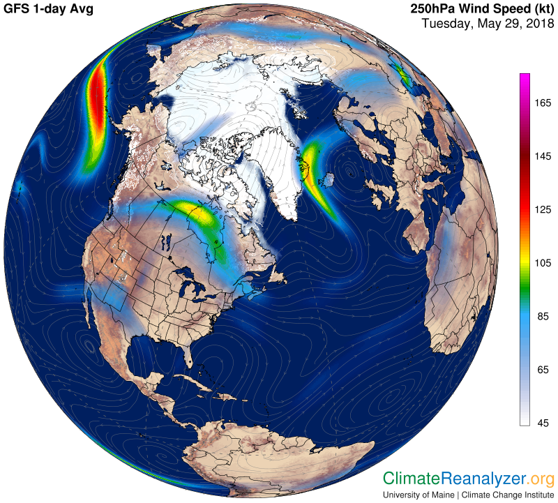
Since the weather-producing jet stream is located on the warm edge of the cold air that caps the high latitudes of our hemisphere, this warming drives the jet stream poleward, resulting in a reduction in the frequency of large-scale cyclones across North America as we head into spring and summer.

As the sun continues to climb higher into the sky after the equinox, melting begins in the ice-choked Arctic and increases its pace throughout the summer before finally experiencing the first freezes of the next cold season in mid-September. So, though the occasional cold morning or dreary, raw day may yet remind us of the wisdom of the old saying, “The first day of spring is one thing, but the first spring day is quite another,” take heart in the fact that, as of March 20th, we have turned the page to an entirely different, more benevolent meteorological reality.

Steve Ackerman and Jonathan Martin, professors in the UW-Madison department of atmospheric and oceanic sciences, are guests on WHA radio (970 AM) at 11:45 a.m. the last Monday of each month.
Category: Seasons

Comments Off on When does spring begin?

How much water is in the atmosphere?

Sitting nearly in the middle of the vast North American continent, Madison has what is known as a continental climate. Continental climates are characterized by large annual extremes in temperature and humidity as well as very distinct seasons.

The continental nature of Madison’s climate is what makes a year’s worth of weather in Madison usually a lot more varied than a year’s worth in Seattle, for instance. There is an astounding 144 degrees difference between the all-time highest (107 on July 13, 1936) and all-time lowest (-37 on Jan. 30, 1951) temperature in Madison.

In addition, the amount of water vapor in the air can range from the barely detectable level in the midst of a deep winter cold spell to as much as 3.5 percent of every breath you take during a severe July heatwave. No matter what the season, the vast majority of the invisible water vapor in the atmosphere is contained in the lowest mile or two from its source at the surface.

At any one instant, the Earth’s atmosphere contains 3.75 million-billion gallons of water vapor – enough to cover the entire surface of the planet with 1 inch of rain if condensed. This amount is recycled, through evaporation powered by the Sun, 40 times each year in what is known as the hydrologic cycle.

In each of these 40 cycles, enough energy is expended to power the U.S. — the largest consumer of energy in the world — for 3,441 years! A truly astounding amount of energy.

Category: Climate, Meteorology, Seasons

Comments Off on How much water is in the atmosphere?