What does the recent cold and snow say about climate change?

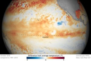
It has been quite a week for discussion of global warming.

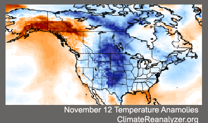
November has been remarkably cold this year for most of the eastern United States.

In Madison, as just one example, the monthly temperature through Friday has been 6.2 degrees Fahrenheit below normal for the month and, with the prospect of more cold to come, it appears the month will end well below normal.

President Donald Trump, taking note of the near-record cold that was expected for the Thanksgiving holiday, wondered, “Whatever happened to Global Warming?”

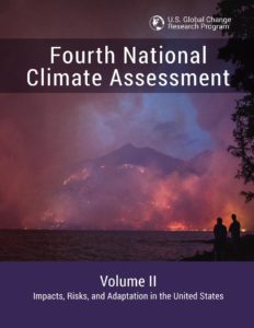
Then, on the day after the holiday, the National Climate Assessment, written before the hurricane season and the California wildfires, was released by the Trump Administration answering his question — it continues.

The report synthesizes more than 1,000 peer-reviewed studies regarding the state of the climate and our growing understanding of the issue.

Among the many important statements made in the report, it says that weather extremes associated with the warming climate “have already become more frequent, intense, widespread or of long duration.”

It also reports that over the last decade or so high impact weather has delivered nearly $400 billion dollars in damage to the country, far outpacing any prior records of destruction.

The bottom line is that scientists have reached solid conclusions regarding the threat that climate change poses to our nation, its infrastructure and the quality of life of our fellow citizens.

America has always risen to urgent challenges and met them with courage and eventual success. It is time we turned that indomitable resolve toward this existential problem.

Category: Climate, Seasons

Comments Off on What does the recent cold and snow say about climate change?

What is El Niño and does it affect Wisconsin?

Sea surface temperature anomalies.

El Niño is a combined atmosphere/ocean circulation anomaly in the tropical Pacific Ocean in which unusually warm surface water extends westward from the coast of Peru into the mid-Pacific. One is predicted to develop this winter, which may impact our winter weather.

The warmer than normal waters support persistent tropical thunderstorms in that same region — where such storms are ordinarily rare.

Because the Earth spins on its axis like a merry-go-round, air near the equator (like the outer edge of the merry-go-round) has higher momentum than air at, say, 30 degrees north latitude.

Thus, if equatorial air can be exported to higher latitudes, large wind speeds can be produced at those latitudes. At the top of the thunderstorms, air with high momentum is exhausted into the upper atmosphere and heads north to alter the position of the jet stream. That alteration of the jet stream position and strength tends to make us warmer in the winter.

So unusually warm waters lead to persistent thunderstorms in the eastern equatorial Pacific that alter the position of the jet stream and contribute to unusual winter weather conditions for us. The downstream impact of the altered jet stream is a winter in Wisconsin with less snowfall than normal.

El Niño conditions lead to above-average winter precipitation across the southern United States, and lower than normal snowfall in the northwest U.S. The shift in the position of the jet stream drives winter storms across the southern U.S., leading to above-normal snowfall there and less snowfall in the northern regions of the U.S.

The forecast challenge for winter conditions is that an El Niño doesn’t guarantee a given snow or temperature pattern; it just makes it likely that we will have a milder winter.

Steve Ackerman and Jonathan Martin, professors in the UW-Madison Department of Atmospheric and Oceanic Sciences, are guests on WHA radio (970 AM) at 11:45 a.m. the last Monday of each month.
Category: Meteorology, Phenomena, Seasons

Comments Off on What is El Niño and does it affect Wisconsin?

Ask the Weather Guys: What causes cold air outbreaks?

Almost no one in the Midwest will be unaffected by the remarkable cold air outbreak that occurred over the past weekend.

And if you think that we were paid a rather early visit by such air this year, you are right.

A vigorous cold air outbreak such as we just experienced is usually a midwinter, not late fall, phenomenon.

As with most unusual events in the atmosphere, this cold air outbreak was a commingling of circumstances — some common and some not — brought to extreme by perfect timing.

Because the sun has long since set for the winter at the North Pole, the endless night is a breeding ground for very cold air masses. As we head into mid-November, the darkness has crept southward into northern Canada bringing with it an even more proximate source of very cold air. That circumstance is the same every year.

The high altitude flow of air around the hemisphere is most often predominantly west to east. Occasionally, large north-south meanders develop in this flow, bringing warm tropical air toward the pole in the northward directed flow and cold, polar air toward the equator in the southward directed flow.

Late last week a strong ridge of high pressure developed at high altitude over the west coast of the United States and Canada. The eastern side of such a ridge is characterized by southward flow which, in this case, ushered a mass of cold air from high latitude central Canada into the central United States while simultaneously providing support for the strong offshore flow across California that supported the devastating fires in that state.

Steve Ackerman and Jonathan Martin, professors in the UW-Madison Department of Atmospheric and Oceanic Sciences, are guests on WHA radio (970 AM) at 11:45 a.m. the last Monday of each month.
Category: Meteorology, Seasons

Comments Off on Ask the Weather Guys: What causes cold air outbreaks?

Can we see satellites at night?

Satellites are visible in the night sky when sunlight reflects off of their solar panels.

Yes, you can see satellites in particular orbits as they pass overhead at night.

Viewing is best away from city lights and in cloud-free skies. The satellite will look like a star steadily moving across the sky for a few minutes. If the lights are blinking, you probably are seeing a plane, not a satellite.

Satellites do not have their own lights that make them visible. What you will see is sunlight being reflected off the satellite, often off the large solar arrays that provide power to the satellites.

These satellites are very high above Earth, about 200 to 300 miles, so while you are in the darkness of night, the sun can still shine on the satellite. Eventually the satellite will fly into the Earth’s shadow and then it will suddenly disappear from view.

The International Space Station (ISS) can be very bright. It orbits Earth at an altitude of about 215 miles traveling at a speed of 17,200 mph. It is a large object with large, highly reflective solar panels making it the brightest of human objects orbiting Earth. It can be as bright as Venus.

You can find out when the ISS is flying over you by visiting this web site, go.madison.com/peqjy, and entering your state and city, or selecting one of the near-by cities from a list.

Weather satellites that track clouds and whose images are shown in animations on many websites are orbiting 22,000 miles above us and appear fixed over the equator. You will not be able to see those moving across the sky.

Category: Meteorology

Comments Off on Can we see satellites at night?

Is the number of tornadoes increasing?

Tornadoes are sometimes not seen and thus sometimes not counted. Particularly early in the record keeping.

But scientists interested in this question have studied the change in the key ingredients that form tornadoes, such as wind shear, atmospheric stability and humidity. The more often those ingredients are present, the more likely tornadoes are to form.

So, a recent study counted the number of tornado reports between 1979 and 2016 and also tracked the conditions favorable for tornado formation. They found that increases in the ingredients were reflected in a larger number of tornadoes.

The study found that since 1979, some places have seen increases in tornadoes and other regions showed a decreasing trend. Tornadoes are decreasing in Oklahoma, Texas and Kansas but are increasing in states along the Mississippi River and farther east, including Wisconsin.

Spatial trends in U.S. tornado frequency.
Source: Northern Illinois University

The Great Plains have seen a slight decrease, with the biggest change in central and eastern Texas; however, Texas still has the most tornadoes of any state. The west coast of Florida is the only place east of the Mississippi that didn’t show an increase.

While tornado alley — Oklahoma, Colorado and central and eastern Texas — has the most tornadoes, the states with the deadliest tornadoes are Alabama, Missouri, Tennessee and Arkansas.

Scientists aren’t sure of why the eastward shift has been observed. It could be dry conditions in the plains moving farther eastward.

Why does this matter? The shift eastward means that more people and homes are exposed to a tornado threat.

Steve Ackerman and Jonathan Martin, professors in the UW-Madison Department of Atmospheric and Oceanic Sciences, are guests on WHA radio (970 AM) at 11:45 a.m. the last Monday of each month.
Category: Meteorology, Severe Weather

Comments Off on Is the number of tornadoes increasing?