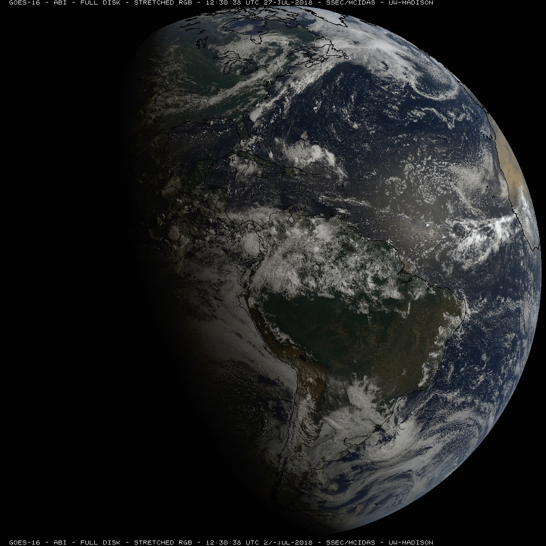
How do I prepare for severe weather?

Lightning crackles over the Root River just west of downtown Racine as a storm front moves over the area. The National Weather Service advises: When thunder roars, go indoors. (Photo credit: Racine Journal Times Archives)

Severe summer weather can happen at any time and anywhere. The three biggest severe weather killers in the United States today are tornadoes, lightning and flash floods. Your best protection is to be prepared.

First, you need access to reliable weather information so you remain alert for potential weather hazards. Get a NOAA weather radio for weather updates. Subscribe to wireless emergency alerts, or WEAs, that provide free messages to your cell phone that will alert you about severe weather in your area. For more information on WEA Alerts, go to www.ready.gov/warning-systems-signals.

Tune in to local forecasters on radio or television to get additional information. Local forecasters are experts on regional weather and can interpret observations and conditions for you.

In the case of tornado, go into a tornado shelter or the basement or into a small interior room on the lowest floor of a building, such as a bathroom or closet. Protect yourself from flying debris and stay away from windows. If you are in a mobile home or car, leave it and go to a strong building.

As for lightning, the National Weather Service, or NWS, advocates the simple rule: “When thunder roars, go indoors!” Avoid flagpoles, metal fences, golf carts, baseball dugouts and farm equipment. If you are in a forest, seek shelter in a low area under a thick growth of bushes or small trees.

Move to high ground when threatened by flooding. Stay out of flooded areas. Never drive your car across a flooded road, even if you think the water is shallow. As the NWS says, “Turn around, don’t drown.”

The NWS provides information and ideas for preparing for severe weather and you can learn more safety tips, available at www.ready.gov/severe-weather.

Category: Severe Weather, Weather Dangers

Comments Off on How do I prepare for severe weather?

When does spring begin?

The 2018 vernal equinox occurs Tuesday March 20th at 11:15 a.m.

Civilizations throughout the long span of human history in our hemisphere have celebrated this day as it marks the beginning of a continuous six-month period during which the daytime is longer than the nighttime.

The consequences of this dramatic change are many. Of course, the weather begins to noticeably warm around this time of year, reaching an annual maximum approximately four months from now before slipping, at first slowly, back toward the coolness of fall.

Since the weather-producing jet stream is located on the warm edge of the cold air that caps the high latitudes of our hemisphere, this warming drives the jet stream poleward, resulting in a reduction in the frequency of large-scale cyclones across North America as we head into spring and summer.

As the sun continues to climb higher into the sky after the equinox, melting begins in the ice-choked Arctic and increases its pace throughout the summer before finally experiencing the first freezes of the next cold season in mid-September. So, though the occasional cold morning or dreary, raw day may yet remind us of the wisdom of the old saying, “The first day of spring is one thing, but the first spring day is quite another,” take heart in the fact that, as of March 20th, we have turned the page to an entirely different, more benevolent meteorological reality.

Steve Ackerman and Jonathan Martin, professors in the UW-Madison department of atmospheric and oceanic sciences, are guests on WHA radio (970 AM) at 11:45 a.m. the last Monday of each month.
Category: Seasons

Comments Off on When does spring begin?

How much water is in the atmosphere?

Sitting nearly in the middle of the vast North American continent, Madison has what is known as a continental climate. Continental climates are characterized by large annual extremes in temperature and humidity as well as very distinct seasons.

The continental nature of Madison’s climate is what makes a year’s worth of weather in Madison usually a lot more varied than a year’s worth in Seattle, for instance. There is an astounding 144 degrees difference between the all-time highest (107 on July 13, 1936) and all-time lowest (-37 on Jan. 30, 1951) temperature in Madison.

In addition, the amount of water vapor in the air can range from the barely detectable level in the midst of a deep winter cold spell to as much as 3.5 percent of every breath you take during a severe July heatwave. No matter what the season, the vast majority of the invisible water vapor in the atmosphere is contained in the lowest mile or two from its source at the surface.

At any one instant, the Earth’s atmosphere contains 3.75 million-billion gallons of water vapor – enough to cover the entire surface of the planet with 1 inch of rain if condensed. This amount is recycled, through evaporation powered by the Sun, 40 times each year in what is known as the hydrologic cycle.

In each of these 40 cycles, enough energy is expended to power the U.S. — the largest consumer of energy in the world — for 3,441 years! A truly astounding amount of energy.

Category: Climate, Meteorology, Seasons

Comments Off on How much water is in the atmosphere?

Is winter winding down?

Ice accumulations formed by winds and sub-freezing temperatures hold to tree branches along the Lakeshore Path on the campus of UW-Madison in November. After mid-Feburary, it is rather unlikely we will experience another cold air event. (Photo credit:: John Hart, State Journal Archives)

Despite a prolonged deep freeze that straddled the end of December and the first week of January, during which we had below-zero morning low temperatures on 12 of 13 consecutive days, the month of January is likely to end at just about normal for Madison.

We are not, however, out of the woods just yet. Climatologically, the last week of January/first week of February is the coldest time of the year as a result of several physical factors.

First, the number of daylight hours at high latitudes in the Northern Hemisphere is very small – reaching its annual minimum on Dec. 21. For nearly a month, the increase in sunlight is very meager.

This means that very little input of solar energy is available in high latitude locations and nearly continual nighttime cooling prevails. Consequently, the generation of cold air masses is at its peak during this first four to six weeks of winter.

In line with these factors, Madison’s all-time lowest temperature, minus-37, was recorded on Jan. 30, 1951.

After the first week of February, however, the daily increase in daylight accelerates everywhere – this is even noticeable in Madison as the time of sunset is appreciably later by then.

As a result, it becomes more difficult to manufacture truly frigid air at high latitudes and this, in turn, greatly reduces our chances of an additional prolonged blast of arctic air.

So, even though the medium-range forecast suggests we will have another cold air event in the coming 10 days, take solace in the fact that it is rather unlikely that an additional such event will follow after mid-February. The cosmological and climatological decks are stacked against it.

Category: Meteorology, Seasons

Comments Off on Is winter winding down?

What was 2017 weather summary?

People move through flooded streets in Havana after the passage of Hurricane Irma in September. The 2017 season had the highest number of major hurricanes since 2005. (Photo credit: Ramon Espinosa, Associated Press)

The National Oceanic and Atmospheric Administration has completed its scientific analysis and the globally averaged surface temperature for 2017 was the third-highest since record keeping began in 1880.

The warmest year is 2016, and 2015 is the second warmest. Since 1977 global temperatures have been at least nominally above the 20th century average. The six warmest years on record have occurred since 2010.

Everyone has his or her own personal stories of top 2017 weather events. Chances are many will remember the cold weather at the end of December.

Temperatures were mostly above normal in the first two-thirds of December, particularly the week before Christmas. Then Arctic air pushed south across the region and extended all the way to the Gulf of Mexico in the last week of the year, bringing cold temperatures to southern Wisconsin. The cold outbreak was enough to make average December temperature in southern Wisconsin below normal by 2 to 3 degrees. A lake-effect snowfall dumped 66 inches in Erie, Pennsylvania, at the end of December.

At the end of the year, southern Wisconsin was 20 inches below normal in total snowfall. Yet the average annual Northern Hemisphere snow cover extent during 2017 was above the 1981-2010 average, the largest since 1985 and the eighth-largest in the 1968-2017 record.

Recent trends in the decline of Arctic sea ice extent continued in 2017. The average annual sea ice extent in the Arctic was approximately 4.01 million square miles, the second-smallest annual average in the 1979-2017 record.

The 2017 hurricane season was one of only six seasons on record to feature multiple Category 5 hurricanes. This was the second season on record (after 2007) to feature two hurricanes making landfall at Category 5, Irma’s landfalls on multiple Caribbean islands and Maria’s landfall on Dominica. This season had the highest number of major hurricanes since 2005.

On a warmer note, the summer average temperature for Wisconsin was about average, with summer precipitation above average.

Category: Climate, Meteorology

Comments Off on What was 2017 weather summary?