What were the significant U.S. weather events of summer 2020?

This NASA Earth Observatory graphic from September 2020 employs OMPS data (Ozone Mapping and Profiler Suite) on the NOAA-20 satellite plus VIIRS data from the Suomi-NPP satellite, CALIPSO data from NASA/CNES, and emissions data from the Global Fire Emissions Database (GFED). (Credit: Joshua Stevens)

Meteorologists consider summer to be the three-month period of June through August, and 2020 had some interesting and significant weather events.

Certainly, first on the list is the fire weather in the West. Colorado had its largest fire on record, the Pine Gulch fire, and California has to date the second-, third- and fourth-largest fires in its state history. Wildfires in the West continue to burn into autumn.

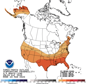
Record heat impacted many locations across the West, Southeast and Northeast. The average temperature for the Lower 48 for August 2020 was 2.2 degrees above average, ranking it the fourth warmest in the historical record. This marked the 428th consecutive month with temperatures above the 20th-century average. Wisconsin’s average summertime temperatures were 1 to 2 degrees above normal across the state.

Below-average precipitation was observed across much of the West, Rockies, Deep South, and from portions of the central Plains to the Northeast. Precipitation across Wisconsin was slightly above normal, with the largest departures from normal in northeastern Wisconsin.

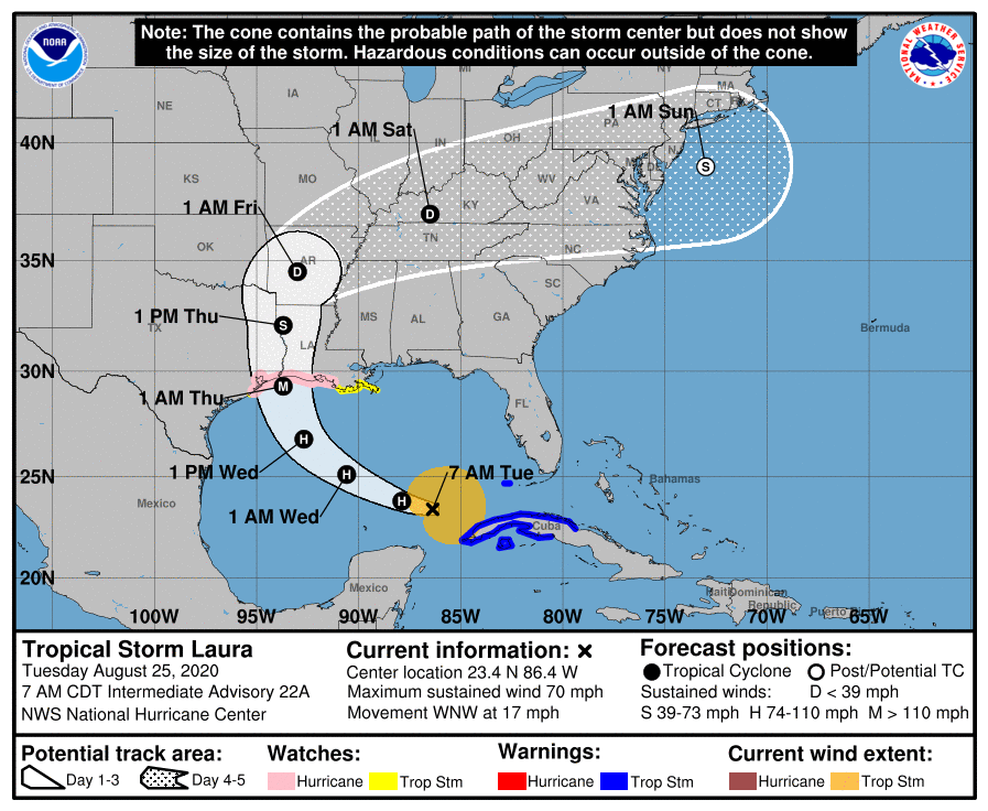
Hurricane Laura made landfall in southwest Louisiana on Aug. 27 as a Category 4 storm with 150 mph winds. Another high-wind event, a derecho, raced across 700 miles from Iowa to Ohio with reports of winds of more than 100 mph. That Aug. 10 storm caused significant damage to crops and infrastructure across the central US.

Wisconsin had 17 tornadoes during this summer, spread over six days. There were no deaths associated with the tornadoes.

Category: Seasons, Severe Weather

Comments Off on What were the significant U.S. weather events of summer 2020?

What is the Farmer’s Almanac forecast for winter?

Temperature Forecast During December, January, & February: Warm. This outlook is based on a general trend of increasing temperatures during the past years and decades.

The Farmers’ Almanac recently published its 2020-2021 winter forecast. For the Midwest region, it predicts a cold winter with normal to below-normal temperatures.

But don’t count on its forecast, as there is no proven skill. The Farmers’ Almanac does not share how it makes its forecast, so it cannot be judged scientifically.

The Farmers’ Almanac also makes a weather forecast for specific time periods in a given season. Such detailed forecasts can be announced but are not trustworthy scientifically.

Seasonal weather forecasting is a science challenge. The National Oceanic and Atmospheric Administration’s Climate Prediction Center (CPC) also makes seasonal forecasts. It explains the underlying principles of its forecast and provides validation of its forecasts publicly (see www.cpc.ncep.noaa.gov/products/predictions/long_range/tools/briefing/seas_veri.grid.php).

These modern-day seasonal forecasts rely on known relationships between climate and some key forcing mechanisms, such as the El Niño. An El Niño is a periodic warming of the equatorial Pacific Ocean between South America and the Date Line. This warming is a natural variation of the ocean and is used to predict departures from average conditions rather than to make specific weather forecasts. For example, a year with a strong El Niño leads to less snow fall than average in Wisconsin. These seasonal forecasts also take into account the climatic impacts of other global oscillations uncovered by the research of atmospheric scientists.

There is about a 60% chance of a La Niña, a cooling of the equatorial Pacific Ocean between South America and the Date Line, developing during the Northern Hemisphere fall and continuing through winter 2020-21. This will influence global weather patterns. The CPC predicts there is an equal chance our wintertime temperatures will be above, below, or at average conditions. They are also calling for a 40% to 50% chance that our winter precipitation will be above normal.

Category: Climate, Seasons

Comments Off on What is the Farmer’s Almanac forecast for winter?

How accurate were forecasts of Hurricane Laura?

When Hurricane Laura made landfall just south of Lake Charles, Louisiana, at 2 a.m. Thursday, it did so as the strongest hurricane to strike the state in more than 160 years and one of the top 10 strongest landfalling storms in U.S. history.

By the time the storm came ashore 30 miles south of Lake Charles, it likely packed gusts to over 150 mph. Indeed, the peak gust at Lake Charles was 137 mph — truly incredible considering that the city is 30 miles from the coastline.

Even though the storm hit a rather less populated part of the Gulf Coast, nearly 1.5 million people were involved in some sort of evacuation and more than 900,000 lost power. The storm surge was between 12 and 21 feet, and some locations received more than 18 inches of rain.

Despite these manifestations of Laura’s destructive potential, thus far only 14 people have died from the storm and several of those were victims of carbon monoxide poisoning, not the weather/flooding itself. The remarkably low death toll is almost surely a result of the extremely accurate forecast for this storm’s location and time of arrival.

A 5-day forecast map for Hurricane Laura from the National Hurricane Center.
Click on image for an animation

While Laura was still getting organized over Haiti, some 87 hours before it made landfall, the National Hurricane Center predicted the time of landfall precisely and the location to within 0.6 miles (the equivalent of sinking a 900 foot putt). The intensity was underforecast as a result of the unexpectedly rapid intensification in the last 24 hours before it crashed ashore. The peak winds increased by 65 mph in that interval.

Nonetheless, in the post-storm analysis that is now ongoing, the exceptional timing and placement forecasts will undoubtedly rise to the top of the list of reasons why this powerful storm did not take more lives.

Category: Meteorology, Severe Weather, Tropical

Comments Off on How accurate were forecasts of Hurricane Laura?

Does the ozone hole occur over both poles?

Arctic stratospheric ozone reached its record low level of 205 Dobson units, shown in blue and turquoise, on March 12, 2020. (Image credit: NASA’s Goddard Space Flight Center)

The ozone hole refers to the appearance of very low values of ozone in the stratosphere.

The winter atmosphere above Antarctica is very cold. It occurs typically high over the continent of Antarctica, during the Southern Hemisphere’s spring. The cold temperatures result in a temperature gradient between the South Pole and the Southern Hemisphere middle latitudes, which results in strong westerly stratospheric winds that encircle the South Pole region.

These strong winds, called the Polar Vortex, prevent warm air from the equator from reaching these polar latitudes. These extremely cold temperatures inside the strong winds help to form unique types of clouds called Polar Stratospheric Clouds, or PSC. PSCs begin to form during June, which is wintertime at the South Pole.

Chemicals on the surface of the particles composing PSCs result in chemical reactions that remove the chlorine from the atmospheric compounds. When the Sun returns to the Antarctic stratosphere in the spring (our fall), sunlight splits the chlorine molecules into highly reactive chlorine atoms that rapidly deplete ozone. The depletion is so rapid that it has been termed a “hole in the ozone layer.”

An Arctic ozone hole is rare, but one did develop this spring. The winter of 2019-20 was unusual. The cold temperatures in the Northern Hemisphere polar region were present all winter long without ‘weather’ disrupting the circulation pattern.

PSC were abundant throughout the dark winter months, creating a larger reservoir of reactive chlorofluorocarbon (CFC) byproducts than usual. As the Sun returned through late February and early March, destruction of ozone over the Arctic occurred rapidly. The 2020 Artic ozone hole came to an end on April 23.

Satellite observations routinely measure ozone across the planet. The lowest ozone values over the Arctic are less severe than the hole that forms every year over Antarctica.  

Category: Meteorology, Phenomena, Seasons

Comments Off on Does the ozone hole occur over both poles?

What does the rest of the hurricane season look like?

On August 18th 1969, Hurricane Camille, the second-worst hurricane in U.S. history, made landfall on the Mississippi coast with 190-mph winds at Bay St. Louis. Camille claimed 256 lives.

Though the official Atlantic basin hurricane season runs from June 1 to Nov. 30, the peak of the season historically runs from mid-August to mid-October. During that subset of the entire season, well more than 70% of all storms in the last 100 years have occurred.

The actual peak of the season is on or about Sept. 12.

This year’s season has gotten off to a robust start with 11 tropical storms and two hurricanes so far.

A number of research and forecasting groups with years of experience in the practice of forecasting hurricane activity have recently updated their forecasts for this season.

On Aug. 5, a group at Colorado State University, led by Dr. Phil Klotzbach, revised its forecast in calling for 24 named storms, 10 hurricanes, and four major hurricanes. They based this update on the persistence of low vertical wind shear, low surface pressures, and much warmer than average sea-surface temperatures in the tropical Atlantic since July.

The next day, the National Oceanic and Atmospheric Administration (NOAA) released its revised seasonal forecast calling for an “extremely active” season with 19 to 25 named storms, seven to 11 hurricanes and three to six major hurricanes.

An above-normal Atlantic Hurricane Season is now very likely. (Credit: NOAA)

NOAA has only rarely forecast such an active season. Thus, as we enter the heart of the hurricane season, conditions appear to be ripe for an unusually active and potentially destructive next two months.

Category: Meteorology, Severe Weather, Tropical

Comments Off on What does the rest of the hurricane season look like?