What is a waterspout?

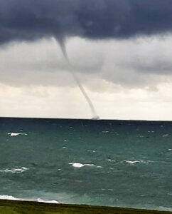
There are two types of waterspouts: fair weather waterspouts and tornadic waterspouts.

A fair weather waterspout is a whirlwind that forms beneath a cumulus cloud and over water. It’s generally not associated with thunderstorms.

A fair weather waterspout develops on the surface of the water and moves upward. Before you see the waterspout, you may see a funnel cloud hanging from the bottom of the cumulus cloud. A waterspout forms as the rotating funnel draws up water.

Fair weather waterspouts form in light wind conditions so they tend to stay in one place.

The Florida Keys, Gulf of Mexico, and Chesapeake Bay are common regions for waterspouts.

Waterspout on Lake Ontario in September 2020. Photo credit: Spencer Russell

They also occur over the Great Lakes. Between Sept. 28 and Oct. 4, 2020, there were 232 waterspouts over the Great Lakes. There was also another waterspout outbreak this year on the Great Lakes between Aug. 16 and Aug. 18, when the count was 88 spouts.

These large outbreaks resulted from a cold Canadian air mass moving over the Great Lakes. That increased the normal drop in temperature with height, making the air near the surface more prone to rising.

Severe thunderstorms that produce tornadoes that form over water or move from land to water become tornadic waterspouts. Tornadic waterspouts develop in the thunderstorm and move downward towards the ground.

Most fair weather waterspouts are much weaker than the weakest tornado. However, if you are in a boat and see one you should consider it dangerous. You can try to move away by steering your boat at right angles to its movement. If you can’t get out of the way, put on your lifejacket (which you should already have on) and protect yourself from flying debris.

Category: Meteorology, Phenomena

Comments Off on What is a waterspout?

Do the Rocky Mountains influence our weather?

Our string of beautiful days at the end of last week were related, believe it or not, to the presence of the Rocky Mountains hundreds of miles to our west.

The U.S. Rocky Mountain range via satellite.

Last week, the atmospheric flow at levels just above the mountains’ height was oriented almost directly across the high terrain. In such a case, like water flowing over a pebble in a stream, the air is forced to sink on the downwind — or lee — side of the mountains. As air sinks, it moves to higher pressures and is compressed. Upon being compressed, the air warms. Thus, whenever the flow above mountain height is directed as it was last week, very warm temperatures develop over Nebraska and the Dakotas.

The resulting warm air is then pushed eastward by the winds and is dragged toward the Great Lakes in a process known as “warm air advection.” On Friday that warm air advection was very strong and led to a high temperature for the day of 79 degrees. If not for some wispy high clouds early in the afternoon on Friday, we may well have reached 80 degrees or higher.

The last time Madison was officially 80 degrees or warmer was Sept. 2. The earliest day on which Madison has ever recorded its last 80-degree day of the year was Sept. 2, 1977. Thus, since the mercury stopped at 79 on Friday, we now have a very good chance of tying that unusual record — even though the early fall has been very pleasant.

Just for completeness, the all-time latest 80-degree day in Madison’s history is Oct. 23 so, if we fail in the first quest, perhaps we can succeed in overturning the second.

Steve Ackerman and Jonathan Martin, professors in the UW-Madison Department of Atmospheric and Oceanic Sciences, are guests on WHA radio (970 AM) at 11:45 a.m. the last Monday of each month.

Category: Meteorology, Seasons

Comments Off on Do the Rocky Mountains influence our weather?

Why are cold snaps in autumn so short-lived?

Early tinges of autumn color appear on a maple tree Thursday along Arboretum Drive in Madison. It can get cold in October, but typically not for long. (Photo credit: John Hart, State Journal)

Over the past weekend southern Wisconsin experienced its first cold snap of the season with widespread morning lows in the lower 30s on Friday and Sunday mornings.

Very often cold snaps in the autumn are very short-lived as this recent example was, affecting usually one or two nights at most.

There are a variety of reasons for this brevity.

First, cold snaps at this time of year require a substantial southerly excursion of cold air from high-latitude Canada to get us cold.

Though the Arctic night creeps ever farther south each day after the autumnal equinox, its southerly progress is slow.

Consequently, cold air production is limited to the very highest latitudes well into November, which means that any cold air that makes it as far south as Madison is not well-connected to a broader reservoir of cold air that would allow the cold to remain.

Second, there is little snow on the ground even in central Canada at this time of year and so the cold air that does migrate southward is modified (warmed) to a greater degree on that migration at this time of year than in the late fall and winter, when snow cover is widespread.

Third, the lack of snow on the ground in Madison itself limits the longevity of cold snaps. That’s even true in the wintertime.

Overnight cooling over a snowfield can reinvigorate the chill of a cold snap and render it longer-lasting as a result.

So, if you were complaining about the cold this weekend, be glad we are still in October and much more likely to experience a quick rebound.

Category: Meteorology, Seasons

Comments Off on Why are cold snaps in autumn so short-lived?

How does weather affect fall colors?

The bright red and purple colors of autumn leaves come from anthocyanin pigments, which are made from leftover glucose trapped within the leaves of some trees, such as maples. (Photo credit: La Crosse Tribune archives)

Astronomical fall began on Sept. 22.

Climatologists consider fall as the months of September, October and November. The fall season is also associated with pumpkin patches, fresh apples and beautiful foliage.

Leaves are green in the summer because they contain chlorophyll, which reflects green light more than other colors. Other colors are absorbed by chlorophyll for photosynthesis.

During autumn, the green chlorophyll disappears from the leaves as the leaves stop their food-making process, and yellow and orange colors appear. These colors have been in the leaves all along but we can’t see them in the summer because of the chlorophyll.

The color orange comes from carotene, and the yellows from xanthophyll. The bright red and purple colors come from anthocyanin pigments, which are made from leftover glucose trapped within the leaves of some trees, such as maples.

Brilliant fall colors with bright red and purple colors require conditions in which leaves can make a lot of anthocyanin pigments. The brilliance of a fall color season is a function of the weather.

Sunny days and cool nights are the key weather ingredient for brilliant fall colors. The best weather conditions are bright sunny days and cool, but not frosty, nights.

A drab autumn has lots of cloudy days and warm nights. Leaves begin to turn before we have any frosts. An early frost speeds up the fall of the leaves and brings a quick end to the fall color. A few hard frosts can cause the leaves to wither and fall from the tree without changing color.

Many southern Wisconsin regions have not experienced frost. Of course, too much winds, or heavy precipitation would bring the leaves down.

The pandemic has reduced the travel plans of many. But this weekend might be a good time to go for a ride to see the colors.

Category: Phenomena, Seasons

Comments Off on How does weather affect fall colors?

Are we seeing evidence of climate change?

This image provided by the European Space Agency, (ESA) shows the glacier section that broke off the Nioghalvfjerdsfjorden fjord, roughly 50 miles long and 12 miles wide. The glacier is at the end of the Northeast Greenland Ice Stream, where it flows off land and into the ocean. Scientists with Denmark’s National Geological Survey see it as evidence of rapid climate change leading to the disintegration of the Arctic’s largest remaining ice shelf. 

Last week was an alarming week in weather and climate news.

Hurricane Sally bore down on the Gulf Coast with fury and flooding, while four other tropical storms churned away simultaneously in the Atlantic. This is only the second time ever, and first since 1971, when such prolific tropical storminess has characterized the Atlantic basin.

In the northeastern Arctic, a 42-square-mile section of the Greenland ice sheet broke off and was set adrift. Locally, our sunsets and sunrises have been substantially more orangey as a consequence of smoke in the skies from the record western wildfires that are raging nearly a full month before their usual annual peak. These fires, part of a prolonged hot and dry spell that has resulted in what might be the world’s highest recorded temperature ever — 130 degrees on Aug. 16 in Death Valley, California — and a record high of 121 degrees in Los Angeles on Sept. 6 are manifestations of the climate change about which we have been warned for several decades.

In the face of such devastating evidence, President Donald Trump asserted last week “it will start getting cooler” and, regarding climate change, “I don’t think science knows, actually.” Thousands of hard-working, intelligent and dedicated scientists do know, actually — the planet is warming and the consequences of that warming are increasingly becoming headline news with devastating effects to millions of people around the globe.

Disrespect for hard-fought scientific expertise costs lives — a lesson that our nation seems reluctant to acknowledge six months into an unending pandemic, even while other alarm bells loudly ring.

Category: Climate, Seasons

Comments Off on Are we seeing evidence of climate change?