What causes a mid-latitude cyclone to develop?

GOES East water vapor view of a mid-latitude cyclone from spring 2019

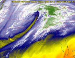
Our recent weekend storm on Nov. 14-15 was the first strong storm of the autumn/winter season.

As you found yourself caught in the strong winds, you may well have wondered how do storms like this one come to be?

That has been the central motivating question in meteorological science for most of the past 100 years. During that time, meteorologists have learned a great deal about how such storms are formed.

In most instances, two or more days before the storm is noticed at the surface of the Earth, processes are at work in the upper troposphere. Specifically, at the height of the jet stream (about 6 miles above the surface), weak downward vertical motions begin to drag the tropopause downward into the middle troposphere. This process eventually results in the creation of a mid-level vortex, a region of counterclockwise rotating winds, at about 3 miles above the ground.

Once generated, this vortex is then moved around by the atmospheric winds in its vicinity. At the forward side of this moving vortex, the air is forced to rise. Such upward vertical motion evacuates air from the lower troposphere, lowering the pressure at the surface. Simultaneously, the upward vertical motion produces clouds and precipitation.

So long as the mid-level vortex continues to intensify and move, so too does the surface cyclone. In many cases, the mid-level vortex eventually becomes quasi-stationary and positioned directly above the surface cyclone. This usually marks the end of the intensification for the storm though it can still deliver high-impact weather at this stage.

Steve Ackerman and Jonathan Martin, professors in the UW-Madison Department of Atmospheric and Oceanic Sciences, are guests on WHA radio (970 AM) at 11:45 a.m. the last Monday of each month.

Category: Meteorology, Seasons, Severe Weather

Comments Off on What causes a mid-latitude cyclone to develop?

How is Wisconsin winter weather affected by La Niña?

La Niña is likely to continue through the Northern Hemisphere winter 2020-21 (~95% chance during January-March) and into spring 2021 (~65% chance during March-May). (Image credit: NOAA/NWS/NCEP/Climate Prediction Center)

Both La Niña and El Niño refer to big changes in the sea-surface temperature across much of the eastern tropical Pacific Ocean.

The water temperatures off the west coast of South America are typically 60 to 70 degrees. During a La Niña, these waters get as much as 7 degrees colder. These La Niña conditions recur every few years and last nine to 12 months, though some events have lingered for as many as two years. This cooling results from a strengthening of the winds over the tropical Pacific and its interaction with the underlying ocean waters.

This year, a La Niña event developed in the tropical Pacific from August to September. The latest forecasts indicate a high likelihood — 90% — of tropical Pacific sea surface temperatures remaining at La Niña levels until the end of the year. Most models indicate the 2020-21 La Niña is likely to be a moderate to strong event.

Wisconsin winters tend to have more precipitation and near-average temperatures during a typical La Niña. Above-average precipitation is expected over the Great Lakes from December through February.

The strength of a La Niña varies from year to year. A strong La Niña occurred in 2007-08, when Madison had more than 100 inches of snow, shattering the all-time seasonal snowfall record for the city.

Elsewhere in the United States, La Niña conditions in winter mean warmer and drier than normal weather in the Southeast and Southwest and colder than normal weather in the Northwest. With a well-established La Niña, the Pacific Northwest is wetter than normal in the late fall and early winter.

Category: Phenomena, Seasons

Comments Off on How is Wisconsin winter weather affected by La Niña?

How unusual is the current warm spell?

Summer heat is invading the fall season. (Graphic: NOAA/NCEI Climate at a Glance)

After a rather persistently cold October in which the monthly averaged temperature was 3.5 degrees below normal, the first week of November has been remarkably pleasant with high temperatures at or above 68 every day since Election Day.

Naturally, such warm weather in November arouses curiosity regarding the frequency of November days with high temperatures at or above 70 degrees in Madison.

There have been only 31 days that have reached this mark in the last 81 years, so it is a nearly 1-in-100 event. Even more interesting is how often, and for duration, consecutive November days have been at or above 70 degrees.

In the last 81 years, there have been seven occasions in which at least two consecutive November days have been that warm, five of those seven since 1999. In both 2008 and 2015 there were three consecutive days, Nov. 3-5 and Nov. 2-4, respectively, that got that warm.

Today we may be making a run at the fifth 70-plus day in a row, which would place this month in its own category, perhaps for years to come. This kind of abnormality is akin to someone breaking Joe DiMaggio’s 56-gave hitting streak by hitting in 75 straight games. Even if we fail to set this extraordinary record, if we can make it to 68, we will have had seven straight November days at that temperature, which is utterly remarkable.

Category: Climate, Seasons

Comments Off on How unusual is the current warm spell?

Does the moon affect the weather?

A full moon descends in the morning sky behind a Great Blue Heron rookery near the village of Johnson Creek in Jefferson County. (Photo credit: John Hart, State Journal archives)

Tides in the ocean are caused by the gravitational force between Earth and the moon. There are also atmospheric tides.

Lunar gravity affects the density of the thermosphere, which is the largest layer of the atmosphere. This is also where many satellites and the International Space Station orbit Earth. This lunar-induced drag is small, but it has to be included in the models used to predict the satellites’ orbits. The moon also affects the pressure at Earth’s surface.

When the moon is overhead, its gravitation pull causes Earth’s atmosphere to bulge toward it. Since the pressure at the surface is determined by the amount of air above you, the pressure, or weight, of the atmosphere on that side of the planet increases.

The fact that air pressure changes were correlated to the position of the moon was first detected in 1847 using ground-based measurements. The change is very small and was detected using careful statistical analysis on a long data record. A correlation with temperature at the surface was found in 1932.

A relatively recent study by atmospheric scientists at the University of Washington found that rain is slightly lighter when the moon is higher in the sky. You wouldn’t notice this difference as the change is only about 1 percent of the total rainfall.

Which is also not enough to impact other aspects of weather. The scientists discovered this by careful statistical analysis of special observation made from satellites over a 15-year period, from 1998 to 2012.

Category: Meteorology, Seasons

Comments Off on Does the moon affect the weather?

What is the status of the ozone hole?

The ozone hole is a region where there is severe depletion of the layer of ozone — a form of oxygen — in the upper atmosphere that protects life on Earth by blocking the sun's ultraviolet rays. (Image credit: NASA)
The ozone hole is a region where there is severe depletion of the layer of ozone — a form of oxygen — in the upper atmosphere that protects life on Earth by blocking the sun’s ultraviolet rays. (Image credit: NASA)

Ozone occurs about 18 miles above the Earth’s surface.

Ozone is both caused by and provides protection from damaging ultraviolet energy emitted by the sun. The development of an atmospheric “ozone layer” allowed life to move out of the oceans and onto land.

The amount of ozone in the atmosphere is routinely measured from satellites. Typically, the Antarctic ozone hole has its largest area in early September and lowest values in late September to early October. This year it was measured to be one of the largest and deepest in recent years, covering just over 9 million square miles.

The ozone hole occurs high over the continent of Antarctica. It is the appearance of very low values of ozone in the stratosphere. The winter atmosphere above Antarctica is very cold. The cold temperatures result in a temperature gradient between the South Pole and the Southern Hemisphere middle latitudes, which results in strong westerly stratospheric winds that encircle the South Pole region.

These extremely cold temperatures inside the strong winds help to form unique types of clouds called Polar Stratospheric Clouds, or PSCs. They begin to form during June, which is wintertime at the South Pole. Chemicals on the surface of the particles composing PSCs result in chemical reactions that remove the chlorine from the atmospheric compounds. When the sun returns to the Antarctic stratosphere in the spring (our fall), sunlight splits the chlorine molecules into highly reactive chlorine atoms that rapidly deplete ozone. The depletion is so rapid that it has been termed a “hole in the ozone layer.”

The Montreal Protocol bans emissions of ozone-depleting chemicals, and that is having a good impact. Observations show the area of the ozone hole is decreasing.

Category: Phenomena, Seasons

Comments Off on What is the status of the ozone hole?