Does the ozone hole occur over both poles?

Arctic stratospheric ozone reached its record low level of 205 Dobson units, shown in blue and turquoise, on March 12, 2020. (Image credit: NASA’s Goddard Space Flight Center)

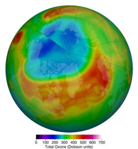
The ozone hole refers to the appearance of very low values of ozone in the stratosphere.

The winter atmosphere above Antarctica is very cold. It occurs typically high over the continent of Antarctica, during the Southern Hemisphere’s spring. The cold temperatures result in a temperature gradient between the South Pole and the Southern Hemisphere middle latitudes, which results in strong westerly stratospheric winds that encircle the South Pole region.

These strong winds, called the Polar Vortex, prevent warm air from the equator from reaching these polar latitudes. These extremely cold temperatures inside the strong winds help to form unique types of clouds called Polar Stratospheric Clouds, or PSC. PSCs begin to form during June, which is wintertime at the South Pole.

Chemicals on the surface of the particles composing PSCs result in chemical reactions that remove the chlorine from the atmospheric compounds. When the Sun returns to the Antarctic stratosphere in the spring (our fall), sunlight splits the chlorine molecules into highly reactive chlorine atoms that rapidly deplete ozone. The depletion is so rapid that it has been termed a “hole in the ozone layer.”

An Arctic ozone hole is rare, but one did develop this spring. The winter of 2019-20 was unusual. The cold temperatures in the Northern Hemisphere polar region were present all winter long without ‘weather’ disrupting the circulation pattern.

PSC were abundant throughout the dark winter months, creating a larger reservoir of reactive chlorofluorocarbon (CFC) byproducts than usual. As the Sun returned through late February and early March, destruction of ozone over the Arctic occurred rapidly. The 2020 Artic ozone hole came to an end on April 23.

Satellite observations routinely measure ozone across the planet. The lowest ozone values over the Arctic are less severe than the hole that forms every year over Antarctica.  

Category: Meteorology, Phenomena, Seasons

Comments Off on Does the ozone hole occur over both poles?

What does the rest of the hurricane season look like?

On August 18th 1969, Hurricane Camille, the second-worst hurricane in U.S. history, made landfall on the Mississippi coast with 190-mph winds at Bay St. Louis. Camille claimed 256 lives.

Though the official Atlantic basin hurricane season runs from June 1 to Nov. 30, the peak of the season historically runs from mid-August to mid-October. During that subset of the entire season, well more than 70% of all storms in the last 100 years have occurred.

The actual peak of the season is on or about Sept. 12.

This year’s season has gotten off to a robust start with 11 tropical storms and two hurricanes so far.

A number of research and forecasting groups with years of experience in the practice of forecasting hurricane activity have recently updated their forecasts for this season.

On Aug. 5, a group at Colorado State University, led by Dr. Phil Klotzbach, revised its forecast in calling for 24 named storms, 10 hurricanes, and four major hurricanes. They based this update on the persistence of low vertical wind shear, low surface pressures, and much warmer than average sea-surface temperatures in the tropical Atlantic since July.

The next day, the National Oceanic and Atmospheric Administration (NOAA) released its revised seasonal forecast calling for an “extremely active” season with 19 to 25 named storms, seven to 11 hurricanes and three to six major hurricanes.

An above-normal Atlantic Hurricane Season is now very likely. (Credit: NOAA)

NOAA has only rarely forecast such an active season. Thus, as we enter the heart of the hurricane season, conditions appear to be ripe for an unusually active and potentially destructive next two months.

Category: Meteorology, Severe Weather, Tropical

Comments Off on What does the rest of the hurricane season look like?

What are the “dog days of summer”?

In late August and early September, look for a hint of the changing season in the predawn sky: Orion the Hunter and Sirius the Dog Star. The very noticeable constellation Orion the Hunter rises before dawn at this time of year, recognizable for the short straight line of three stars that make up Orion’s Belt. And the sky’s brightest star Sirius – sometimes called the Dog Star because it’s part of the constellation Canis Major the Greater Dog – follows Orion into the sky as the predawn darkness gives way to dawn. (Image credit: EarthSky.org)

The term “dog days of summer” refers to a time of hot and humid weather in the Northern Hemisphere, usually in July and early August.

The phrase is not a reference to lazy dogs lying around on hot and humid days. It refers to the stars in the sky.

This time period coincides with the rising of the star of Sirius, or the Dog Star. Sirius is part of the “Greater Dog” constellation Canis Majoris. Sirius follows Orion, as a faithful dog would.

Sirius is by far the brightest proper star in the night sky, which caused ancient astronomers to take note of it around the world. In ancient Greece and Rome, the dog days were believed to be a time of drought, bad luck and unrest.

The Old Farmer’s Almanac considers the dog days to be the 40 days beginning July 3 and ending August 11. Over time, constellations drift with reference to Earth. For the ancient Romans, the dog days of summer occurred from about July 24 to around August 24.

There is no formal meteorological or climatological definition.

A traditional verse forecasts bad outcomes when this time of year is associated with rainfall, and a good year when it is sunny:

Dog Days bright and clear

Indicate a happy year;

But when accompanied by rain,

For better times, our hopes are vain.

Category: Meteorology, Seasons

Comments Off on What are the “dog days of summer”?

Where are we on hurricane season thus far?

The Atlantic basin hurricane season is off to a roaring start in 2020.

The first nine named storms of the 2020 Atlantic Basin Hurricane Season.
Credit: CIMSS, SSEC and NASA

The official season stretches from June 1 through Nov. 30. One measure of the activity of a season is the number of named storms — those that reach or exceed sustained winds of 39 mph — that season accrues.

This year, for the sixth year in a row, Atlantic tropical storms formed before the official start of the season with Arthur and Bertha developing in May.

NOAA had predicted an abnormally active hurricane season this year with as many as 19 named storms, with three to six of them likely to develop into fearsome Category 3, 4 or 5 storms.

With the development of Hurricane Isaias on Friday, we are already at nine for the season as we are just about to enter the most active part of it. An average hurricane season in the Atlantic produces 12 named storms with about six of those becoming hurricanes.

Among the most important considerations regarding these storms is how many of them will strike land and where — nearly impossible to predict on the seasonal time scale.

Certainly, a higher number of total storms would suggest a greater chance of at least one of them making a major landfall so an abnormal frequency is of concern.

Recent years make this point well. The 2010 Atlantic season had 19 named storms, the third most of any season since 1851. However, only one storm, and only at tropical storm strength, made landfall in the U.S. that year.

In contrast, the 1992 season had only seven named storms but one of those was Hurricane Andrew which devastated south Florida as one of only four Category 5 storms to ever make landfall in the US.

Category: Meteorology, Severe Weather, Tropical

Comments Off on Where are we on hurricane season thus far?

What is the heat index?

When the temperature is high but the relative humidity is low, the heat index can be less than the actual temperature. (Photo credit: Steve Apps, State Journal archives)

The heat index indicates how hot it feels. It is expressed as a function of air temperature and the relative humidity.

The heat index temperature is for standing in the shade and light winds; when exposed to direct sunlight, the heat index value can be increased by up to 15 degrees F.

When our bodies get hot we cool down by sweating. The sweating does not directly cool our bodies; it is the evaporation of the sweat that cools us down.

If the air has a high humidity, then the rate of evaporation is reduced. That hampers the body’s ability to maintain a nearly constant internal body temperature. That is why we are uncomfortable on hot, muggy days.

When the temperature is high but the relative humidity is low, the heat index can be less than the actual temperature. That’s because cooling by evaporation of sweat is very efficient in these situations.

However, high relative humidities prevent evaporation and make it seem hotter than it really is because our bodies cannot cool down. In these cases, the heat index is greater than the actual temperature.

The National Weather Service (NWS) will initiate alert procedures when the heat index is expected to exceed 105° to 110°F (depending on local climate) for at least two consecutive days.

The NWS will issue a heat advisory when the heat index is predicted to be 100°F. You are then advised to limit vigorous outdoor activity and drink plenty of fluids. Never leave children or pets in a locked car.

A heat wave is a period of abnormally and uncomfortably hot and usually humid weather.

The World Meteorological Organization defines a heat wave as when the daily maximum temperature for more than five consecutive days exceeds the average maximum temperature by 9°F.

Category: Meteorology, Seasons

Comments Off on What is the heat index?