How does weather affect fall colors?

The bright red and purple colors of autumn leaves come from anthocyanin pigments, which are made from leftover glucose trapped within the leaves of some trees, such as maples. (Photo credit: La Crosse Tribune archives)

Astronomical fall began on Sept. 22.

Climatologists consider fall as the months of September, October and November. The fall season is also associated with pumpkin patches, fresh apples and beautiful foliage.

Leaves are green in the summer because they contain chlorophyll, which reflects green light more than other colors. Other colors are absorbed by chlorophyll for photosynthesis.

During autumn, the green chlorophyll disappears from the leaves as the leaves stop their food-making process, and yellow and orange colors appear. These colors have been in the leaves all along but we can’t see them in the summer because of the chlorophyll.

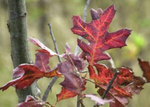
The color orange comes from carotene, and the yellows from xanthophyll. The bright red and purple colors come from anthocyanin pigments, which are made from leftover glucose trapped within the leaves of some trees, such as maples.

Brilliant fall colors with bright red and purple colors require conditions in which leaves can make a lot of anthocyanin pigments. The brilliance of a fall color season is a function of the weather.

Sunny days and cool nights are the key weather ingredient for brilliant fall colors. The best weather conditions are bright sunny days and cool, but not frosty, nights.

A drab autumn has lots of cloudy days and warm nights. Leaves begin to turn before we have any frosts. An early frost speeds up the fall of the leaves and brings a quick end to the fall color. A few hard frosts can cause the leaves to wither and fall from the tree without changing color.

Many southern Wisconsin regions have not experienced frost. Of course, too much winds, or heavy precipitation would bring the leaves down.

The pandemic has reduced the travel plans of many. But this weekend might be a good time to go for a ride to see the colors.

Category: Phenomena, Seasons

Comments Off on How does weather affect fall colors?

Are we seeing evidence of climate change?

This image provided by the European Space Agency, (ESA) shows the glacier section that broke off the Nioghalvfjerdsfjorden fjord, roughly 50 miles long and 12 miles wide. The glacier is at the end of the Northeast Greenland Ice Stream, where it flows off land and into the ocean. Scientists with Denmark’s National Geological Survey see it as evidence of rapid climate change leading to the disintegration of the Arctic’s largest remaining ice shelf. 

Last week was an alarming week in weather and climate news.

Hurricane Sally bore down on the Gulf Coast with fury and flooding, while four other tropical storms churned away simultaneously in the Atlantic. This is only the second time ever, and first since 1971, when such prolific tropical storminess has characterized the Atlantic basin.

In the northeastern Arctic, a 42-square-mile section of the Greenland ice sheet broke off and was set adrift. Locally, our sunsets and sunrises have been substantially more orangey as a consequence of smoke in the skies from the record western wildfires that are raging nearly a full month before their usual annual peak. These fires, part of a prolonged hot and dry spell that has resulted in what might be the world’s highest recorded temperature ever — 130 degrees on Aug. 16 in Death Valley, California — and a record high of 121 degrees in Los Angeles on Sept. 6 are manifestations of the climate change about which we have been warned for several decades.

In the face of such devastating evidence, President Donald Trump asserted last week “it will start getting cooler” and, regarding climate change, “I don’t think science knows, actually.” Thousands of hard-working, intelligent and dedicated scientists do know, actually — the planet is warming and the consequences of that warming are increasingly becoming headline news with devastating effects to millions of people around the globe.

Disrespect for hard-fought scientific expertise costs lives — a lesson that our nation seems reluctant to acknowledge six months into an unending pandemic, even while other alarm bells loudly ring.

Category: Climate, Seasons

Comments Off on Are we seeing evidence of climate change?

What were the significant U.S. weather events of summer 2020?

This NASA Earth Observatory graphic from September 2020 employs OMPS data (Ozone Mapping and Profiler Suite) on the NOAA-20 satellite plus VIIRS data from the Suomi-NPP satellite, CALIPSO data from NASA/CNES, and emissions data from the Global Fire Emissions Database (GFED). (Credit: Joshua Stevens)

Meteorologists consider summer to be the three-month period of June through August, and 2020 had some interesting and significant weather events.

Certainly, first on the list is the fire weather in the West. Colorado had its largest fire on record, the Pine Gulch fire, and California has to date the second-, third- and fourth-largest fires in its state history. Wildfires in the West continue to burn into autumn.

Record heat impacted many locations across the West, Southeast and Northeast. The average temperature for the Lower 48 for August 2020 was 2.2 degrees above average, ranking it the fourth warmest in the historical record. This marked the 428th consecutive month with temperatures above the 20th-century average. Wisconsin’s average summertime temperatures were 1 to 2 degrees above normal across the state.

Below-average precipitation was observed across much of the West, Rockies, Deep South, and from portions of the central Plains to the Northeast. Precipitation across Wisconsin was slightly above normal, with the largest departures from normal in northeastern Wisconsin.

Hurricane Laura made landfall in southwest Louisiana on Aug. 27 as a Category 4 storm with 150 mph winds. Another high-wind event, a derecho, raced across 700 miles from Iowa to Ohio with reports of winds of more than 100 mph. That Aug. 10 storm caused significant damage to crops and infrastructure across the central US.

Wisconsin had 17 tornadoes during this summer, spread over six days. There were no deaths associated with the tornadoes.

Category: Seasons, Severe Weather

Comments Off on What were the significant U.S. weather events of summer 2020?

What is the Farmer’s Almanac forecast for winter?

Temperature Forecast During December, January, & February: Warm. This outlook is based on a general trend of increasing temperatures during the past years and decades.

The Farmers’ Almanac recently published its 2020-2021 winter forecast. For the Midwest region, it predicts a cold winter with normal to below-normal temperatures.

But don’t count on its forecast, as there is no proven skill. The Farmers’ Almanac does not share how it makes its forecast, so it cannot be judged scientifically.

The Farmers’ Almanac also makes a weather forecast for specific time periods in a given season. Such detailed forecasts can be announced but are not trustworthy scientifically.

Seasonal weather forecasting is a science challenge. The National Oceanic and Atmospheric Administration’s Climate Prediction Center (CPC) also makes seasonal forecasts. It explains the underlying principles of its forecast and provides validation of its forecasts publicly (see www.cpc.ncep.noaa.gov/products/predictions/long_range/tools/briefing/seas_veri.grid.php).

These modern-day seasonal forecasts rely on known relationships between climate and some key forcing mechanisms, such as the El Niño. An El Niño is a periodic warming of the equatorial Pacific Ocean between South America and the Date Line. This warming is a natural variation of the ocean and is used to predict departures from average conditions rather than to make specific weather forecasts. For example, a year with a strong El Niño leads to less snow fall than average in Wisconsin. These seasonal forecasts also take into account the climatic impacts of other global oscillations uncovered by the research of atmospheric scientists.

There is about a 60% chance of a La Niña, a cooling of the equatorial Pacific Ocean between South America and the Date Line, developing during the Northern Hemisphere fall and continuing through winter 2020-21. This will influence global weather patterns. The CPC predicts there is an equal chance our wintertime temperatures will be above, below, or at average conditions. They are also calling for a 40% to 50% chance that our winter precipitation will be above normal.

Category: Climate, Seasons

Comments Off on What is the Farmer’s Almanac forecast for winter?

How accurate were forecasts of Hurricane Laura?

When Hurricane Laura made landfall just south of Lake Charles, Louisiana, at 2 a.m. Thursday, it did so as the strongest hurricane to strike the state in more than 160 years and one of the top 10 strongest landfalling storms in U.S. history.

By the time the storm came ashore 30 miles south of Lake Charles, it likely packed gusts to over 150 mph. Indeed, the peak gust at Lake Charles was 137 mph — truly incredible considering that the city is 30 miles from the coastline.

Even though the storm hit a rather less populated part of the Gulf Coast, nearly 1.5 million people were involved in some sort of evacuation and more than 900,000 lost power. The storm surge was between 12 and 21 feet, and some locations received more than 18 inches of rain.

Despite these manifestations of Laura’s destructive potential, thus far only 14 people have died from the storm and several of those were victims of carbon monoxide poisoning, not the weather/flooding itself. The remarkably low death toll is almost surely a result of the extremely accurate forecast for this storm’s location and time of arrival.

A 5-day forecast map for Hurricane Laura from the National Hurricane Center.
Click on image for an animation

While Laura was still getting organized over Haiti, some 87 hours before it made landfall, the National Hurricane Center predicted the time of landfall precisely and the location to within 0.6 miles (the equivalent of sinking a 900 foot putt). The intensity was underforecast as a result of the unexpectedly rapid intensification in the last 24 hours before it crashed ashore. The peak winds increased by 65 mph in that interval.

Nonetheless, in the post-storm analysis that is now ongoing, the exceptional timing and placement forecasts will undoubtedly rise to the top of the list of reasons why this powerful storm did not take more lives.

Category: Meteorology, Severe Weather, Tropical

Comments Off on How accurate were forecasts of Hurricane Laura?