New book from Jonathan Martin of The Weather Guys delves into the origins of modern meteorology

Jonathan Martin, half of the “Ask the Weather Guys” duo, wrote a book about the father of modern weather systems.

The technology that allows us to know the temperature, humidity and chance of precipitation on an hourly basis is something on which we’ve come to expect and rely. But ever wonder how the technology of predicting the weather came about?

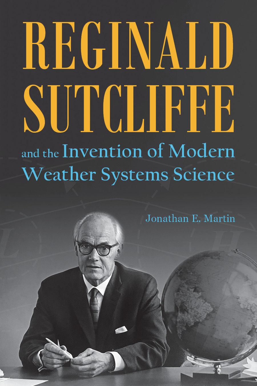
UW-Madison professor Jonathan Martin, one of the writers of the State Journal’s “Ask the Weather Guys” column, answers that question in his new book “Reginald Sutcliffe and the Invention of Modern Weather Systems Science,” which came out March 15. He’ll be discussing the book during a virtual event through Mystery to Me bookstore later this month.

Q: Your biography is on Reginald Sutcliffe, who you credit as the father of our modern day weather predicting science, but start by telling me a little about yourself.

A: I’ve been at the University of Wisconsin-Madison since the fall of 1994, 27 years, in the same department, teaching about and researching aspects of the mid-latitude cyclone and how it connects to the climate system. Every fall I teach a class in mid-latitude weather systems where Sutcliffe made his major contributions. In the spring I most often teach an intro to weather and climate class

Q: Who was Reginald Sutcliffe?

A: I think it is fair to say that he is one of the giants in developing our modern understanding … of how weather systems really work. Until he came along knowledge was based entirely on observations of weather systems — known events of the past. Now it’s much more physically based. Sutcliffe was a giant in pulling that information out of the ether. The foundation of knowledge that he laid was essential in that revolution. In a way, he’s like a science Moses. He brought us to the promised land and never got there himself.

Q: What led Sutcliffe, who is British and lived from 1904 to 1991, to this revolution?

A: He was a Ph. D. mathematician who graduated in 1927. At the time, nearly all positions available for Ph.D mathematicians were jobs as teachers and he didn’t want to do that. He heard from the guidance office at the University of Leeds that the Meteorological Office tended to hire mathematician grads so he took a job with the Meteorological Office. … Through a series of very lucky coincidences he ended up being pushed in a direction where his initial frustration that meteorology was quite non-scientific was remedied by doing research work. … He was commissioned to write a textbook on meteorology for pilot training in 1938. This forced him to read extensively in meteorology and that reading led to an explosion of creativity.

Q: You mentioned he was not a strong believer in computers and their role in weather prediction, why not?

A: I think the reason he was never enthusiastic about numerical weather prediction was that in the initial 15 years of the development of using computers for forecasting, the computer generated forecasts were inferior to those made by experienced professional forecasters like Sutcliffe. It takes expert judgment to make sense of the vast amount of information available to make a reasonable statement of how the weather will evolve.

Q: How did you come to write this book?

A: A graduate professor of mine was a fan of Sutcliffe and thought he had some big insights. I hadn’t heard much about him as an undergrad. It wasn’t until I got the job in Wisconsin, 27 years ago this month, with my first task to prepare a class on mid-latitude cyclones for the fall of 1994, that I recognized him as such an important figure. As I put those notes together it occurred to me that Sutcliffe had his fingerprints on every single major insight that we have about such weather systems. I was touched by his genius.

Q: How does this biography compare to other books you’ve written?

A: I wrote one text book for the intro class and a much more substantial one for my senior level/graduate student course. For me, when you’re an academic, such textbooks can be seen as a logical extension of the professional obligation we all have at Wisconsin to teach and publish new discoveries about nature … we’re all obviously heavy into research. It’s nice to leave a legacy about how you understand things when you write a textbook. But to write a biography … that was a little out of the mainstream. It’s a different, and very exciting feel. I don’t take for granted how lucky I have been to undertake it and, to complete it, really made me proud.

Q: Do you want to do it again?

A: I think if the right subject came about and it was a feasible project. There is something really energizing about breathing life into something that may have been forgotten. Everybody looks at their phone to look at the weather. Some people are interested in why we’re able to do that — from where does that amazing capability arise. It’s because we’ve developed some really rigorous understandings about how the atmosphere works. We’re the first generation of humans to live in the presence of that miracle. I think I’m not the only one who thinks that is an interesting story.

Check it out

What: A virtual visit with author Jonathan E. Martin, whose book “Reginald Sutcliffe and the Invention of Modern Weather Systems Science,” came out earlier this month.

When: March 24 at 7 p.m.

For more information, visit: www.crowdcast.io/e/sutcliffe/register

Category: History, Meteorology

Comments Off on New book from Jonathan Martin of The Weather Guys delves into the origins of modern meteorology

What should I know about the spring equinox?

Satellite image illustrating equal daylight and nighttime on the Equinox.

The spring equinox — also called the vernal equinox — marks the beginning of the spring season in the Northern Hemisphere and the autumn season in the Southern Hemisphere.

This year the equinox arrived at 4:37 a.m. Saturday.

The equinoxes (equi for “equal,” and nox “night”) occur when the sun’s rays strike the equator at noon at an angle of 90 degrees. During the spring and fall equinoxes, the sun is above the horizon for all locations on Earth for 12 hours.

The fastest sunsets and sunrises of the year happen at the equinoxes. By fastest we mean the length of time it takes for the sun to sink below the horizon. At the equinoxes, the sun rises due east and sets due west, no matter where you live. If you live at the equator, the sun appears overhead at noon.

The tilt of the Earth’s axis is responsible for the seasonal variation in the amount of solar energy distributed at the top of the atmosphere. The Earth’s axis is tilted at an angle of 23.5 degrees from its orbital plane.

Because the Earth’s axis always points in the same direction — toward the North Star — the orientation of the Earth’s axis to the sun is always changing as the Earth orbits around the sun. As this orientation changes throughout the year, so does the distribution of sunlight on the Earth’s surface at any given latitude, and this is the cause of the seasons.

On the equinoxes the axis is not pointed at or away from the sun. This results in all areas experiencing a little more than 12 hours of daylight.

Steve Ackerman and Jonathan Martin, professors in the UW-Madison department of atmospheric and oceanic sciences, are guests on WHA radio (970 AM) at 11:45 a.m. the last Monday of each month. Send them your questions at stevea@ssec.wisc.edu or jemarti1@wisc.edu.

Category: Meteorology, Seasons

Comments Off on What should I know about the spring equinox?

Has March been a bit unusual so far?

It has been a fairly benign first two weeks of March for those of us in southern Wisconsin.

2021 Daily Temperatures for Madison through March 12th. Note the large swing from February to March denoted by the black line. Credit: Wisconsin Climatology Office

Through the first 11 days of the month, we have averaged 6.2 degrees above normal. In fact, in the nearly three weeks since Feb. 22 — when we had this season’s maximum snow depth of 16 inches in Madison — we have averaged the same 6.2 degrees above normal.

During that stretch of days, we have had only three (March 1, 2 and 4) where the daily average temperature was below normal — and it was only slightly below at that. The result of this exceptional, uninterrupted stretch of mild weather has been the most rapid disappearance of a substantial snow cover that we have seen in quite some time in Madison.

Officially, March 10 was the first day with a snow depth of zero inches since Dec. 11. During this late-winter mild spell we have lost nearly 1 inch of snow cover each day for nearly three weeks.

It is important to remember that March is not always so kind. In fact, traditionally the week of March 10-17 has been quite wintery on occasion across the country. In 1870, the word “blizzard” was first used to describe a snowstorm in Iowa’s Estherville Indicator (March 14). New York City was visited by its worst snowstorm ever on March 12-13, 1888. The worst blizzard in the history of Minnesota and North Dakota occurred on March 15, 1941; 4 feet of snow fell at Inwood, Iowa, on March 11, 1962, and the “Storm of the Century” dropped snow from Alabama to Maine on March 13, 1993.

So, if you have been conscious of a certain benevolence to this March’s weather thus far, your instinct is correct.

Steve Ackerman and Jonathan Martin, professors in the UW-Madison Department of Atmospheric and Oceanic sciences, are guests on WHA radio (970 AM) at 11:45 a.m. the last Monday of each month.

Category: Climate, Meteorology, Seasons

Comments Off on Has March been a bit unusual so far?

What is special about March weather?

Leah Salsano, right, and her sister, Kira, of Poynette, check the buckets attached to maple trees that are tapped for sap at the MacKenzie Center. In Wisconsin, March is a prime month for tapping sugar maple trees, and this is when the sap is sweetest. (Photo credit:  Amber Arnold, State Journal)
Leah Salsano, right, and her sister, Kira, of Poynette, check the buckets attached to maple trees that are tapped for sap at the MacKenzie Center. In Wisconsin, March is a prime month for tapping sugar maple trees, and this is when the sap is sweetest. (Photo credit: Amber Arnold, State Journal)

March 1 marks the beginning of spring and kicks off an active and variable weather season. Flooding, temperature swings, tornados and snowstorms are all common springtime weather events.

A flood occurs when water flows into a region faster than it can be absorbed into the soil, stored in a lake or reservoir, or removed in runoff or a waterway into a drainage basin. In early spring, the ground can still be frozen and so cannot absorb the precipitation. Rain and melting snow will instead flow into rivers causing springtime flooding.

As the sun rises higher in the sky and the day’s length gets longer, our temperatures warm. March is the month with the greatest difference between the all-time warmest and coldest days. In March, we often have nighttime temperatures below freezing and daytime temperatures above freezing due to the longer daylight hours. This temperature cycle results in freeze-thaw cycles.

This cycling can cause potholes, as surface water seeps below the surface during the warm days and then freezes at night. The nighttime expansion of the freezing water can cause cracks in the roadway.

This alternate freezing and thawing temperature cycle also causes pressure changes inside trees, resulting in sap flow. Tapping maple trees usually occurs in late winter and early spring. In Wisconsin, March is a prime month for tapping sugar maple trees and this is when the sap is sweetest.

Tornadoes are very destructive events. While tornadoes can occur at any time of the year, tornado outbreaks are probably the weather event most often associated with spring. Tornado activity in the lower 48 states begins to increase in March before peaking in April, May and June.

Snowstorms are not uncommon in March. Their often heavy snowfall can bring down trees and powerlines.

Steve Ackerman and Jonathan Martin, professors in the UW-Madison department of atmospheric and oceanic sciences, are guests on WHA radio (970 AM) at 11:45 a.m. the last Monday of each month. Send them your questions at stevea@ssec.wisc.edu or jemarti1@wisc.edu.

Category: Climate, Seasons

Comments Off on What is special about March weather?

How severe was the Northern Hemisphere winter this year?

Warming in the Northern Hemisphere determined by a shrinking cold pool aloft measured by the National Center for Environmental Prediction (NCEP) reanalysis data. Credit: J. Martin

Today is March 1 so the meteorological winter (December-January-February) is over.

The areal extent of air colder than minus 23 degrees at about 1 mile above the ground throughout December through February is one way of comparing the severity of the Northern Hemisphere winter from one year to the next.

Using the National Center for Environmental Prediction (NCEP) reanalysis data set we have been able to make such a calculation for each winter season since 1948-49. Despite the severe cold snap experienced over much of North America in the middle of February this year, the seasonal average cold pool area over the entire hemisphere was the ninth smallest in the last 73 years. This is consistent with a systematic shrinking of the wintertime cold pool extent that has seen the average seasonal area decrease by nearly 5% since 1948.

This shrinkage is, of course, at the southern edge of the cold pool and is not a function of changes in weather systems that parade around the globe on that edge. Instead, it is a result of increased retention of infrared radiation emitted by the surface of the Earth which is intercepted primarily by the increased concentration of carbon dioxide in the atmosphere.

The monthly average carbon dioxide concentration in the atmosphere for January 2021, the last month for which averaged values were available, was 415.52 parts per million (ppm). That compares to 354.93 ppm just 30 years ago and 316.89 ppm 60 years ago. This means that the rate of increase has more than doubled in the past 30 years.

The shrinking of the wintertime cold pool is a predictable result of this increase — an increase that lies behind the unmistakable global warming that continues to alter the climate.

Steve Ackerman and Jonathan Martin, professors in the UW-Madison department of atmospheric and oceanic sciences, are guests on WHA radio (970 AM) at 11:45 a.m. the last Monday of each month

Category: Climate, Meteorology, Seasons

Comments Off on How severe was the Northern Hemisphere winter this year?