What is the winter solstice?

The Earth makes a complete revolution around the sun once every 365 days, following an orbit that is elliptical in shape.  This means that the distance between the Earth and Sun, which is 93 million miles on average, varies throughout the year.  Seasons are caused by the fact that the Earth is tilted on its axis by 23.5°.  The tilt’s orientation with respect to space does not change during the year; thus, the Northern Hemisphere is tilted toward the sun in June and away from the sun in December, (Image credit: weather.gov)

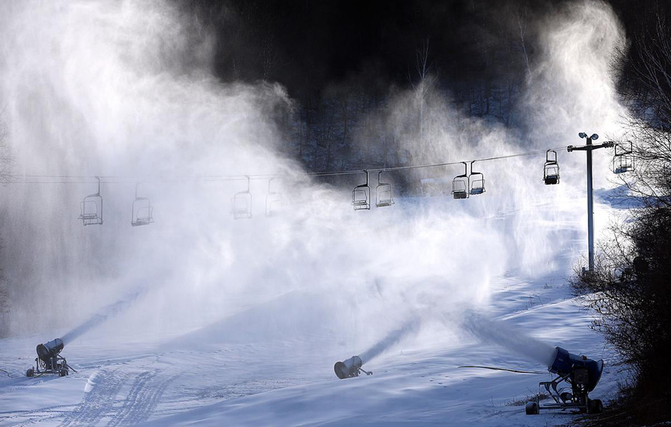
The winter solstice (In Latin, sol, “sun,” and stice, “come to a stop”) is the day of the year with the fewest hours of daylight in the Northern Hemisphere.

In 2021, this occurs for the Northern Hemisphere on Dec. 21 at 9:59 a.m.

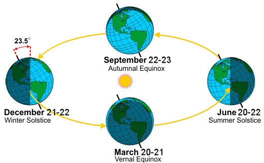
As Earth orbits the sun, its axis of rotation is tilted at an angle of 23.5 degrees from its orbital plane. Because Earth’s axis of spin always points in the same direction — toward the North Star — the orientation of Earth’s axis to the sun is always changing as Earth orbits around the sun.

As this orientation changes throughout the year, so does the distribution of sunlight on Earth’s surface at any given latitude. This links the amount of solar energy reaching a location to the time of year and causes some months of the year to always be warmer than others — in other words, the seasons.

On the Northern Hemisphere’s winter solstice, the northern spin axis is pointed away from the sun and latitudes north of the Arctic Circle (66.5 degrees North) have 24 hours of darkness. Meanwhile, the Southern Hemisphere is having short nights and long days.

The time of day that the sun reaches its highest point in its journey across the sky is called solar noon. In early December, true solar noon comes nearly 10 minutes earlier by the clock than it does at the solstice. With true noon coming later on the solstice, so will the sunrise and sunset times.

This discrepancy between clock time and solar time causes the Northern Hemisphere’s earliest sunset to precede the December solstice. The precise date of the earliest sunset depends on your latitude. The latest sunrise doesn’t come on the solstice either. From mid-northern latitudes, the latest sunrise comes in early January.

After the winter solstice, the days get longer, very slowly at first, but at ever larger daily intervals as the March equinox approaches, marking springtime.

Steve Ackerman and Jonathan Martin, professors in the UW-Madison department of atmospheric and oceanic sciences, are guests on WHA radio (970 AM) at 11:45 a.m. the last Monday of each month. Send them your questions at stevea@ssec.wisc.edu or jemarti1@wisc.edu.

Category: Meteorology, Seasons

Comments Off on What is the winter solstice?

What do we know about the deadly tornado outbreak of last week?

The devastating tornado outbreak that visited Kentucky and Illinois overnight Friday into Saturday morning has left a tragically large death toll in its wake.

NOAA’s Storm Prediction Center posted this Day1 Outlook Moderate Risk almost 10 hours prior to the outbreak, showing possibilities for severe weather this evening into tonight from northeast AR/southeast MO into western TN/KY and southern IL. (Image credit: NOAA/SPC)

Officials estimated Sunday that more than 100 people may have lost their lives to this event, though the recovery of some survivors later in the day gave hope the number might be lower.

The severe outbreak was part of the same storm that gave Wisconsin a rainy (in the south) and snowy (in the north) Friday.

The storm emerged from the central plains around midday on Friday, and in the 12 hours from midnight Friday to midday Saturday its central pressure (one measure of intensity) dropped 13 mb — a notably strong rate of development. It was during this rapid development period that the several killer tornadoes were spawned as the cyclone’s cold front processed very warm and humid air that was originally located to its east. The front, as all dynamically active fronts are, was characterized by a vigorous circulation that forced the warm, moist air upward forcing deep cumulus clouds and severe thunderstorms to develop.

Though such severe tornado outbreaks are a relative rarity in December, the basic ingredients that made this event possible are not uncommon during winter. In fact, storms that deepen even more rapidly than this one did are common enough that a few such storms will likely populate every winter in the Central United States.

Thus, though it might begin to emerge in the press as an example of climate change wreaking havoc with the weather, such a claim in the immediate aftermath of the storms is an unfounded assertion and will require additional analysis to evaluate.

It should be mentioned that the National Weather Service had the development of these tornadoes in sight a couple of days before they occurred, and this expertise surely saved lives.

Steve Ackerman and Jonathan Martin, professors in the UW-Madison department of atmospheric and oceanic sciences, are guests on WHA radio (970 AM) at 11:45 a.m. the last Monday of each month. Send them your questions at stevea@ssec.wisc.edu or jemarti1@wisc.edu.

Category: Meteorology, Seasons, Severe Weather

Comments Off on What do we know about the deadly tornado outbreak of last week?

What kind of autumn did we have temperature-wise?

The changing colors of a maple tree at the UW Arboretum frame Nola Dupuis, left, and Carol Kiemel as they share walk after Madison’s first below-freezing morning of the season at 31 degrees on Oct. 22. (Photo credit: John Hart, State Journal archives)

The pre-winter months of September-October-November (SON) have recently come to an end with some points of interest to be made about the average temperature both locally and around the entire Northern Hemisphere.

Here in Madison, these three months have been quite distinct from each other with September’s average temperature rising 1.7 degrees above normal and October’s rising to 5.5 degrees above normal.

This increasingly warmer start was halted in November, when the average temperature was 1.1 degrees below normal for the month.

The highest temperature during these three months was 88 on Sept. 19, and the last day with a temperature at or above 80 was Oct. 1 (84 degrees).

Oct. 20 was the last day at or above 70 (73 degrees). Two mornings later we had our first below-freezing morning at 31 degrees on Oct. 22. The day after Thanksgiving we got down to 13 degrees, which is the coldest morning of the season thus far.

One way to characterize the temperature around the whole hemisphere is to consider the areal extent of air that is 23 degrees or colder at 850 hectopascals (hPa), a pressure level about 1 mile above sea-level. We have reliable such data back to 1948, and this year’s SON had the 15th-smallest average areal extent since that time, making it the 15th-“warmest” SON in the last 74 seasons. In fact, this year from Oct. 25-28, the hemisphere recorded the smallest areal extents in history for those calendar days.

Thus, for nearly half a week in late October, the Northern Hemisphere was warmer (at 850 hPa) than it has been since at least 1948.

What these rather topsy-turvy autumn temperatures might mean for the coming winter, even hemispherically, is not at all clear. In some years a relatively warm autumn is followed by a much colder winter, whereas in others the warmth of autumn continues unabated throughout the winter.

Steve Ackerman and Jonathan Martin, professors in the UW-Madison department of atmospheric and oceanic sciences, are guests on WHA radio (970 AM) at 11:45 a.m. the last Monday of each month. Send them your questions at stevea@ssec.wisc.edu or jemarti1@wisc.edu.

Category: Uncategorized

Comments Off on What kind of autumn did we have temperature-wise?

How does weather affect snow-making?

Ski resorts often use snow machines to make snow and lay down a good base for the coming season.

Machine-made snow prepares the base at Mt. La Crosse ski hill.
Photo from the La Crosse Tribune Archives

To make snow for ski trails requires temperatures near or below freezing. The humidity also plays a role in snow-making; a lower humidity is better. A low temperature and a low humidity is the best atmospheric condition for snow-makers, as it yields the driest snow.

Wet bulb temperature is the lowest temperature to which air can be cooled by the evaporation of water into the air at a constant pressure. The wet bulb temperature is directly related to both relative humidity and outside air temperature. Web bulb temperatures of less than 20 degrees are ideal for snow-making with snow guns. Those temperatures can produce a dry snow.

Snow can also be made with wet bulb temperatures between 27 and 20 degrees, but the snow will be on the wet side. It is possible to make wet snow with temperatures slightly above freezing but that requires relative humidities less than about 40% (wet bulb temperatures are near 27 degrees).

Snow-making produces snow by mixing air and water. The nozzle of a snow gun produces tiny water droplets that freeze as they travel through the air. Compressed air or fans are used to loft the small droplets over the targeted section of the trail. The water droplets must freeze before hitting the ground, which would produce an ice glaze.

The machine-made snow is more like frozen water droplets than snow crystals. This machine-made snow has a greater density than natural snow but is good for laying a snow base for the season.

The wind also affects snow-making. The wind can help direct the flow of the snow and can help the hang time of a merging snowflake.

Steve Ackerman and Jonathan Martin, professors in the UW-Madison Department of Atmospheric and Oceanic Sciences, are guests on WHA radio (970 AM) at 11:45 a.m. the last Monday of each month and authors of Ask the Weather Guys in the Wisconsin State Journal.

Category: Meteorology, Seasons

Comments Off on How does weather affect snow-making?

Is our recent cold snap a harbinger of things to come?

Our recent cold snap has brought the November average to just 0.5 degrees above normal through the first 17 days of November after a relatively warm October in Madison, where the average temperature was 5.9 degrees above normal.

NOAA’s outlook for the end of November suggests seasonable temperatures for Wisconsin.

It is unlikely we will see a dramatic enough warmup over the last two weeks of the month to get us even close to as warm as we were in October. In fact, the most recent 10-day forecasts suggest continued seasonable to below-seasonable temperatures in southern Wisconsin through the end of November.

Last year the sequence was nearly exactly reversed as we endured a relatively cold October (temperature 3.8 degrees below normal), while November started really warm, with high temperatures at or above 68 degrees every day from Nov. 3-8.

This year we had a trace (or more) of snow on four consecutive days Nov. 4-7. Such dramatic turns from year-to-year point out how much natural variability there is in the weather at nearly any time of year — though it seems especially capricious in the late fall — perhaps because large departures at this time of year are so obviously experienced as extensions of summer (warm) or early indications of winter (cold).

The fact is that these notable departures are not of much predictive value when it comes to forecasting the coming cold season. Even the brewing La Nina conditions in the central tropical Pacific do not offer much guidance for what we might expect this winter as both warm and cold extremes in our region have been known to accompany such conditions.

Steve Ackerman and Jonathan Martin, professors in the UW-Madison Department of Atmospheric and Oceanic sciences, are guests on WHA radio (970 AM) at 11:45 a.m. the last Monday of each month. They also write weekly articles for the Wisconsin State Journal.

Category: Climate, Meteorology, Seasons

Comments Off on Is our recent cold snap a harbinger of things to come?