What causes lightning?

Some people see the shape of Wisconsin in this looping lightning bolt that struck near Hager City on May 31, 2019. (Photo credit: Jerry Zimmer)

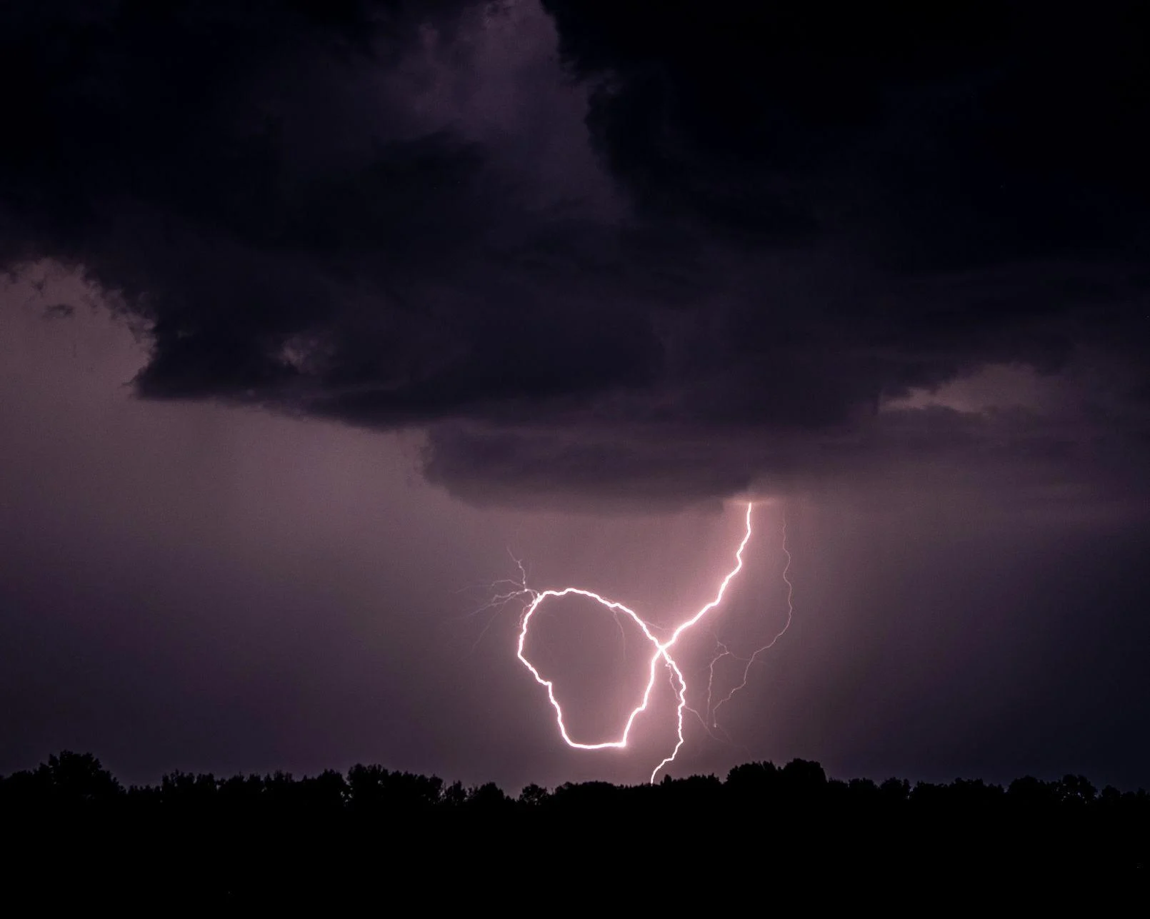
Charges form in a storm composed of ice crystals and liquid water drops. Winds inside the storm cause particles to rub against one another, causing electrons to be stripped off, making the particles either negatively or positively charged.

The charges get grouped in the cloud, often negatively charged near the bottom of the cloud and positively charged up high. This is an electric field, and because air is a good insulator, the electric fields become incredibly strong.

Eventually, the insulating capacity of the air is insufficient, and there is a rapid discharge of electricity that we know as lightning. The flash of lightning temporarily neutralizes the charged regions in the atmosphere, and the charges build up again.

The lightning causes a sudden increase in temperature in the path of a lightning bolt. Pressure change results due to the rapid expansion of the air in the path of a lightning bolt. The rapidly expanding air creates a sound wave that we hear as thunder.

Lightning can travel from cloud to cloud, within the same cloud, or between the cloud and ground. In-cloud lightning discharges are more common than cloud-to-ground discharges and are not as hazardous.

Wisconsin gets hit by lightning about 300,000 times a year, most of that during the spring and summer.

Lighting has different appearances. Staccato lightning is a cloud-to-ground lightning strike which is a short-duration stroke that often, but not always, appears as a single very bright flash and often has considerable branching.

Ribbon lightning occurs in thunderstorms with high cross winds and multiple strokes. The wind will blow each successive stroke slightly to one side of the previous stroke, causing a ribbon appearance.

Heat lightning is a common name for a lightning flash that appears to produce no discernible thunder because it occurs too far away for the thunder to be heard.

Steve Ackerman and Jonathan Martin, professors in the UW-Madison department of atmospheric and oceanic sciences, are guests on WHA radio (970 AM) at 11:45 a.m. the last Monday of each month. Send them your questions at stevea@ssec.wisc.edu or jemarti1@wisc.edu.

Category: Meteorology, Phenomena, Severe Weather

Comments Off on What causes lightning?

What happens to the wintertime cold pool in summer?

We have commented a number of times in the past few years about the areal extent of the hemispheric cold pool of air at 850 mb — about 1 mile above the surface — during the winter. As one might expect, that pool expands dramatically from October through February and then begins to contract as we move toward spring and summer.

Our analysis uses the minus 5 degrees Celsius (23 degrees Fahrenheit) isotherm (line of constant temperature) and has shown that the average winter cold pool area has systematically shrunk in the past 75 years.

One might reasonably wonder if this cold pool survives at all during the height of Northern Hemisphere summer. As it turns out, some summers have a number of days in mid-July on which there is absolutely no air at 850 mb that is as cold as minus 5 Celsius. Roughly half of the past 75 years have had such a “vanishing” cold pool, with many of the other years getting very close to vanishing.

The calendar date on which the lowest areal extent is observed in a given summer varies from around July 4 to as late as July 23. Thus, later this week we will likely be close to the day of the minimum area for the year.

With no intention to distract from the pleasant summer we are all presently enjoying, reaching the annual minimum this week means that by the beginning of next week, the cold pool will begin its slow, inevitable expansion again — culminating in the coldest week of the year in late January when it will cover nearly 70 million square kilometers.

Enjoy the summer — it can’t last.

Steve Ackerman and Jonathan Martin, professors in the UW-Madison department of atmospheric and oceanic sciences, are guests on WHA radio (970 AM) at 11:45 a.m. the last Monday of each month. Send them your questions at stevea@ssec.wisc.edu or jemarti1@wisc.edu.

Category: Climate, Meteorology, Seasons

Comments Off on What happens to the wintertime cold pool in summer?

Are there ideal conditions for fireworks?

Fireworks explode over Lake Monona. The colorful displays have a broad range of good weather conditions in which to be set off and viewed. (Photo credit: Amber Arnold, State Journal archives)

The Fourth of July holiday often is celebrated with community fireworks shows, as well as some backyard fireworks. Fireworks have a broad range of good weather conditions in which to be set off and viewed.

Rain has multiple possible effects on fireworks. Fireworks get very hot. For example, when lit, the tip of a sparkler has a temperature of 1,200 degrees; so once lit, it would take a very heavy rain to extinguish the firework. Damp conditions from rain can hamper the lighting of some fireworks.

Rockets typically shoot below 300 feet in the air, and bottle rockets are less than 75 feet in the air. It would take an extremely low cloud cover to hamper views. Of course, spectators do not want to get rained on while watching a Fourth of July fireworks show.

High humidity could lead to reduced visibilities as a haze, or fog, could develop on the many particles from the smoke near the ground. The smoke particles can serve as condensation nuclei in humid environments. Very dry conditions may result in cancellations of a fireworks show as a precaution to minimize setting off a fire. This could be the situation in areas undergoing drought conditions.

A strong wind could be a problem, as that can make it difficult to light fireworks. Strong winds can also affect the planned path of the fireworks, sending them in unwanted directions. Winds should be less than about 20 mph to be safe.

The wind direction determines where the smoke from the fireworks travel. You would likely want the wind to carry the smoke away from where people are sitting. Completely calm conditions are also not the best as the smoke can linger over the area.

Whatever the weather, we hope you enjoy the Fourth of July holiday.

Steve Ackerman and Jonathan Martin, professors in the UW-Madison department of atmospheric and oceanic sciences, are guests on WHA radio (970 AM) at 11:45 a.m. the last Monday of each month. Send them your questions at stevea@ssec.wisc.edu or jemarti1@wisc.edu.

Category: Uncategorized

Comments Off on Are there ideal conditions for fireworks?

Has this been an unusually hot start to summer?

The recent stretch of warm, humid weather has got some people wondering if we have gotten off to an unusually hot start to summer this year in Madison.

There are a couple of ways one could approach that question. One way is to consider the departure from average for our daily high temperatures since May 1. From that perspective, we have been consistently warmer than normal with May daily highs averaging 3.2 degrees above normal and, June (through Friday) averaging 1.9 degrees above normal.

Another, somewhat more dramatic, way to assess the early heat is to consider the number of days at or above 90 degrees this year. Through June 24, we have already had 10 such days this summer — we had a record five such days in May for the first time in Madison’s history. The average number for a summer in Madison is 13, so we are nearly already there. The all-time Madison record for 90-plus days is 39, set in 1955.

You might remember the summers of 1988 and, more recently, 2012 when Madison had a near-record 35 days with a high temperature at or above 90. By June 27, 1988, we had recorded nine such hot days, the full complement for all of June that year. By June 27, 2012 we had only recorded five days at 90 or above, and in 1955, we had had only one — so we are ahead of the paces set in all three of these remarkable years.

July 2012 had 18 days that were that hot, the bulk of those 18 coming in two streaks of six and seven consecutive 90-plus days. If we are to make a run at 30 or more hot days this summer, we will need a couple extended heat waves such as those from 2012. It will be interesting.

Steve Ackerman and Jonathan Martin, professors in the UW-Madison department of atmospheric and oceanic sciences, are guests on WHA radio (970 AM) at 11:45 a.m. the last Monday of each month. Send them your questions at stevea@ssec.wisc.edu or jemarti1@wisc.edu.

Category: Climate, History, Seasons

Comments Off on Has this been an unusually hot start to summer?

What is an atmospheric river?

An atmospheric river system that drenched parts of California on 14 February 2019— dropping more than 25 centimeters of rain at Palomar Observatory northeast of San Diego, for example, in the observatory’s wettest day on record—is seen in this image from the National Oceanic and Atmospheric Administration’s GOES West satellite. (Image credit: NOAA)

Atmospheric rivers are relatively narrow regions in the atmosphere — typically 250 to 375 miles wide and well over 1,000 miles long.

These sky rivers transport water vapor outside of the tropics to mid-latitude and polar regions. We estimate that 90% of Earth’s north to south water vapor transport is done through atmospheric rivers.

An atmospheric river is identifiable in imagery from weather satellites, appearing as elongated tendrils of moisture stretching from the tropics to the mid-latitudes. This moisture laden air moves away from the Equator and can carry enough water vapor, that if condensed to liquid form, is approximately equivalent to the amount of water carried by 25 Mississippi Rivers.

When an atmospheric river flows over land, extreme flooding events can occur, often through interactions with mid-latitude weather systems. Think of an atmospheric river as a conveyor belt that provides huge amounts of tropical moisture into mid-latitude weather systems, intensifying their rainfall. Extreme, or prolonged, precipitation can create floods, induce mud slides, and cause catastrophic damage to life and property.

Most rivers in the sky, however, are weak and simply provide beneficial rain or snow that is crucial to the water supply of a region. Atmospheric rivers are responsible for a large percentage of the rain and snow in the western United States during winter. When these rivers are forced up the sides of the Sierra Nevada mountains in California and Nevada, the water vapor is condensed into liquid and solid form, bringing much needed rains to the area.

Categorizing the flow of moisture by an atmospheric river can be a useful way to gage the likely impact of these features on precipitation. For example, an Atmospheric River Category 1 (AR Cat 1) is the weakest category and is considered primarily beneficial in terms of rainfall. An AR Cat 2 is moderate and in most situations beneficial, but can be hazardous if the resulting precipitation lasts a long time. The strongest category is AR Cat 5 and that is an exceptional and primarily hazardous event.

Steve Ackerman and Jonathan Martin, professors in the UW-Madison department of atmospheric and oceanic sciences, are guests on WHA radio (970 AM) at 11:45 a.m. the last Monday of each month. Send them your questions at stevea@ssec.wisc.edu or jemarti1@wisc.edu.

Category: Meteorology, Phenomena, Weather Dangers

Comments Off on What is an atmospheric river?