What are straight-line winds?

In May of 2000, authorities said straight-line winds uprooted trees as large as 5 feet in diameter. This tree that fell across Lacy Road near Richardson Road in Fitchburg was about 50 feet away from a home on Eugene Court that had its roof partially ripped off.

In May of 2000, authorities said straight-line winds uprooted trees as large as 5 feet in diameter. This tree that fell across Lacy Road near Richardson Road in Fitchburg was about 50 feet away from a home on Eugene Court that had its roof partially ripped off.

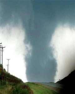
The lack of rotation, or spin, in these winds allows meteorologists to differentiate damage from tornadic winds. Tornadoes scatter objects all over because they rotate so quickly.

Straight-line winds can be hazardous as they can push over objects that can land on top of people, causing injury and death. In July 1999, straight-line winds blew down trees in forested areas of northwest Wisconsin. Many areas had wind speeds of greater than 60 mph, with some exceeding 100 mph.

Thunderstorms have upward air motions, called updrafts. These supply warm moist air to the storm and help to form the precipitation. There are also downdrafts, or sinking air in a storm. Such downdrafts carry air from high elevations in the atmosphere rapidly to the ground. Since wind speed is nearly always much faster at high elevations, the downdrafts carry very high momentum air to the surface, creating the straight-line winds.

Downdrafts also carry liquid water with them. When these downdrafts hit a region of dry air, such as below the cloud base, the drops evaporate. This cools the air in the downdraft, making it denser and thus causing the air in the downdraft to fall to the ground faster. You can sometimes notice this blast of cool air at the surface, often before it rains.

Category: Meteorology, Severe Weather, Weather Dangers

Comments Off on What are straight-line winds?

Why does it smell good after a rain?

Photo by John Hart, State Journal archives.  Elisha Rosas, left, and Carla McCants till soil in a community garden near the Goodman Community Center on Madison's East Side. The pleasant, musky aroma after a rain is similar to what gardeners smell when they turn over their soil.

Photo by John Hart, State Journal archives. Elisha Rosas, left, and Carla McCants till soil in a community garden near the Goodman Community Center on Madison’s East Side. The pleasant, musky aroma after a rain is similar to what gardeners smell when they turn over their soil.

Many times after a rain, there is a distinctive odor in the air — a sort of musky smell. This pleasant fragrance is most common in rains that follow a dry spell.

The phenomenon is referred to as petrichor, from the Greek roots petra (stone) and ichor (the blood of gods in Greek mythology). If you are a gardener, you may find this smell similar to the smell you sense when you turn over your soil. Good organic soils contain bacteria, and a bacterium that is abundant in damp warm soils is actinomycete.

Actinomycetes are a key ingredient in the decomposition of organic materials in the soil.

They thrive when the soil is moist. When the soil dries out, the actinomycetes produce tiny spores. These spores are part of their reproduction cycle.

Rain kicks up these spores when the raindrops hit the ground and make them airborne. Air movements then disperse the spores and carry some of the spores to our nose, where we detect an aroma.

Actinomycetes are very common, which is why you experience the after-the-rain smell in many locations. Oil exuded by certain plants during dry periods also contribute to the smell.

You may have noticed that petrichor is more common after light rains than heavy rains. High-speed photography has shown that light rain results in small bubbles in the rain drop at the soil surface that can transport microbes from the soil when the bubble burst.

Category: Meteorology, Phenomena

Comments Off on Why does it smell good after a rain?

Does Memorial Day or Labor Day have better weather?

A Memorial Day traditionally marks the beginning of the summer while Labor Day marks the end. People are bound to have their own recollections and opinions about which weekend more reliably delivers agreeable weather here in southern Wisconsin and those opinions can be colored by many non-meteorological influences.

If forced to opine on this question while sticking to strictly meteorological factors, we would suggest that Labor Day weekend’s weather is more reliably summerlike. The reason for this comes directly from the fact that Memorial Day comes as winter is ending and Labor Day as winter approaches.

As the winter ends, the entire Northern Hemisphere gradually warms up and the leftover cold air from the polar regions is gradually bled away to lower latitudes where it disappears. This “bleeding” of cold air occurs in distinct blobs, known as cutoff lows.

It is verifiable that there are many more cutoff lows in the hemisphere in May than in September. These cutoffs can sometimes remain over a location for days at a time and negatively impact the local weather by engendering conditions that favor the development of thundershowers and persistent clouds, not to mention below-normal temperatures. Our cooler weather early last week was related to such an event.

Since these features are more common in May, the weather is more prone to these undesirable unsettled periods this month than in September.

Steve Ackerman and Jonathan Martin, professors in the UW-Madison department of atmospheric and oceanic sciences, are guests on WHA radio (970 AM) at 11:45 a.m. the last Monday of each month.

Category: Meteorology, Seasons

Comments Off on Does Memorial Day or Labor Day have better weather?

Ask the Weather Guys: What is brontology?

What is brontology?

Brontology is the scientific study of thunder.

All thunder results from lightning.

A bolt of lightning rapidly heats the air around it, which causes the air to quickly expand and generate a sound wave we call thunder.

This sound wave travels through the atmosphere, and how it travels is a function of the atmospheric conditions.

Some thunder sounds loud and crisp, while in other cases it rumbles and lasts a few seconds.

The sound of thunder is a function of how far away the lightning is from us.

Sound waves interact with objects in multiple ways.

As sound waves move through the atmosphere, they are absorbed by molecules in the air.

The waves can bend around objects, such as trees and leaves, or be absorbed by those objects.This muffles the sound.

Rapid changes in wind speed or wind direction can influence the direction of a sound wave, which can also affect whether we hear it.

As sound waves travel through the open air, they can change the direction in which they are traveling.

In the lower atmosphere, the temperature of the air generally is cooler with increasing height above the ground.

Cooler air over warmer air causes the sound wave to bend upward away from the ground. In this condition, we may see the lightning but not hear the thunder.

We refer to this as heat lightning; we see the light but don’t hear the thunder because the sound wave never reaches our location.

An acoustic shadow zone is an area in which the sound wave does not propagate.

You can be in an acoustic shadow with heat lightning.

— Steve Ackerman and Jonathan Martin, professors in the UW-Madison department of atmospheric and oceanic sciences, are guests on WHA radio (970 AM) at 11:45 a.m. the last Monday of each month.

Category: Meteorology, Phenomena

Comments Off on Ask the Weather Guys: What is brontology?

How do we acquire knowledge about the atmosphere?

How do we gain knowledge about the atmosphere?

It is easy to assume that current, well-accepted scientific knowledge about anything was originally discovered by the grace of inspired geniuses armed with vastly superior intelligence than the average thinking person.

In reality, very often the key ingredient is a roving curiosity and the determination to think about something for a long time.

For instance, the fact that the flow around mid-latitude cyclones (large, organized winter storms) is counterclockwise in the Northern Hemisphere was known long before it was physically understood.

Benjamin Franklin, the first great American scientist, was very interested in a number of meteorological phenomena. He undertook voluminous correspondence with his family in Boston while he was in Philadelphia. By comparing notes about the weather in those letters, Franklin came to recognize that stormy days with northeasterly winds in Philadelphia tended to occur just before such days in Boston.

Further, he noted that when such northeasterly winds were occurring in Boston, the winds were often from the northwest or west in Philadelphia. From these observations, he concluded not only that the flow around the storms was counterclockwise but that the storms were moving entities.

Today, we continue to acquire basic knowledge of the atmosphere combining careful measurements, detailed analyses, and computer-aided simulations. The path to understanding is very often “non-linear” as in this example. That makes it particularly difficult to accurately predict what the exact benefits and applications of basic research might turn out to be. That is why the pursuit of basic research is a fantastic investment with a guaranteed return.

— Steve Ackerman and Jonathan Martin, professors in the UW-Madison department of atmospheric and oceanic sciences, are guests on WHA radio (970 AM) at 11:45 a.m. the last Monday of each month.

Category: Meteorology, Phenomena

Comments Off on How do we acquire knowledge about the atmosphere?