
Article written by Gayle Worland, Wisconsin State Journal
Changes in the weather patterns that brought record-breaking warm temperatures to the Madison area this winter might also mean that a warmer-than-usual summer lies ahead.
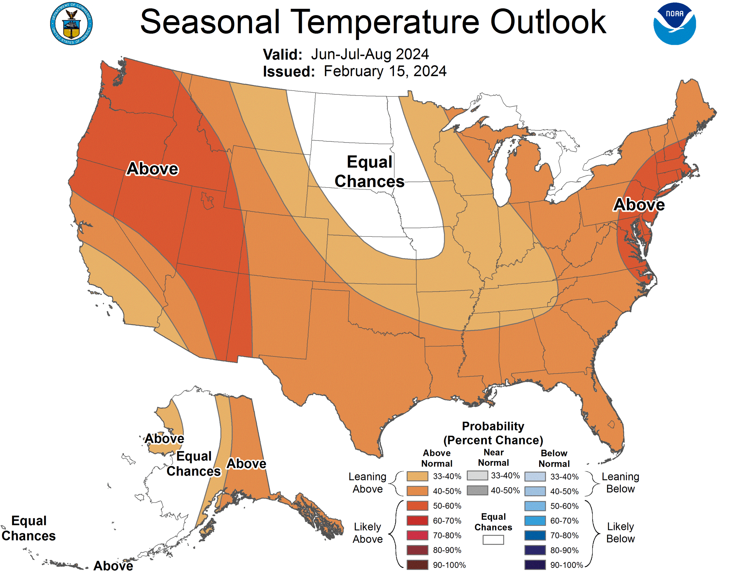
There’s a fair chance that temperatures could rise above normal in June, July and August, and even into early fall, climate scientists say.
“Looking at the outlook for meteorological summer, the three-month period including June, July and August, the probabilities of above-normal temperatures are slightly greater than one-third, or between 33 and 40%,” said Dan Collins, lead climate scientist for the National Oceanic and Atmospheric Administration’s most recent Climate Prediction Center seasonal outlook.
“Later in the summer, the seasonal outlook increases the chance of above-normal temperatures to greater than 40% for the July, August and September period,” Collins said.
Just how high the mercury could rise, it’s not possible to say. Official predictions do not say what exactly “above normal” temperatures could mean, Collins said.
However, Madison’s recent wintertime high temperatures — some into the high 60s — are not directly linked to what’s to come this summer, said Steven Ackerman, emeritus professor for the Department of Atmospheric and Oceanic Sciences and the retired vice chancellor for research and graduate education at UW-Madison.
“This unusual winter we’ve been having is partially due to the El Niño (climate pattern) that we’ve had that’s been pretty strong,” Ackerman explained.
But NOAA recently declared this El Niño is breaking down, he said, “and that means in the summertime the outlook is for ‘neutral’ conditions.”
“Neutral” means that the El Niño year — when the tropical Pacific is warmer than normal — is transitioning to a La Niña year, “which is pretty much the opposite,” Ackerman said. In that “neutral” scenario, “Wisconsin is typically above average in regards to temperature, and pretty much near normal in regards to precipitation,” he said.
“What we typically see after an El Niño is both the minimum temperatures go up as well as the maximum temperatures. And what we’ve been seeing in general is the minimum temperatures seem to be warmer than the increase in the high temperatures during summertime,” Ackerman said. “All of this is sitting on top of a world that is warming.”
Daily high temperatures in Madison for the month of June from 1991 to 2020 ranged from 75 to 82 degrees Fahrenheit, according to the National Weather Service. Low temperatures in June during those same years ranged from 53 to 61 degrees, with steady increases through the month.
Daily normal highs in July from 1991 to 2020 were consistently at 82 degrees, and lows hovered around 61 or 62 degrees. Daily normal El Niño temperatures for August were similar during that time, though they dropped several degrees toward the end of the month.
Last summer, however, was a different story. As Ackerman and UW professor Jonathan Martin, co-authors of the “Ask the Weather Guys” column, which runs on Mondays in the Wisconsin State Journal, wrote in early January: “Our meteorological summer in 2023 was the fifth-driest summer on record (since 1895). An intense heat wave hit in August, peaking from Aug. 22 to Aug. 24. Temperatures reached more than 100 degrees in many areas across the state.”
Wildfire smoke from Canada in late June also was an extreme weather factor in 2023, causing many people to curb outdoor activities and forcing the cancellation of outdoor summer events for several days.
That was followed by Wisconsin’s warmest meteorological winter on record from December 2023 to February 2024, according to the National Weather Service.
If temperatures do soar in the coming summer and residents crank up the window fans or air conditioning, Madison Gas and Electric is equipped to serve any increased needs for electricity, said MGE communications manager Steve Schultz.
“MGE has sufficient capacity to meet the energy needs of our customers this summer, even if demand is higher overall, and we prepare for all sorts of weather conditions,” he said.
“Utilities are required to have enough generation capacity to provide power to all customers when demand for power is at its peak, or highest. For example, on the hottest day of the year when everyone is running their air conditioners,” Schultz said. “In Wisconsin, utilities also are required to have a reserve capacity margin above what they need to serve all customers when demand is at its peak.”
Under current predictions, precipitation in the Madison area is expected to be close to normal this summer. In the month of June from 1991 to 2020, that meant 5.28 inches; in July and August during those same years, 4.51 inches and 4.16 inches respectively.
“I hope we get adequate precipitation at timely intervals,” said Ed Hopkins, assistant state climatologist at the UW-Madison department of Atmospheric and Oceanic Sciences.
“Not a deluge in one day and nothing for the next month. It would be wonderful to have 1 inch of rain a week here in the corn belt, for the development of crops.”