
The weather observing stations of the National Weather Service operate in fully automatic mode and have sensors that measure visibility.
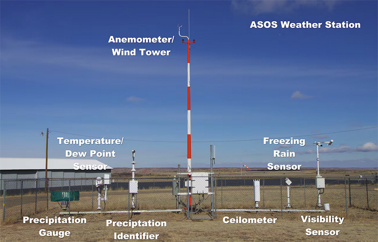
These instruments sense the forward scattering characteristics of light to measure the extinction coefficient of a high intensity beam directed at a volume of air close to the sensor. This provides an accurate measurement over a range of visibilities. The use of light within the visible spectrum also allows the sensor to simulate human perception of visibility.
There are a smaller number of stations where there is still a human observer to estimate visibility (e.g. at airfields). When people make the measurements, they are estimating the maximum distance away that they can see an object located near or on the ground. The object should be identifiable against the background. If the visibility varies with direction, the lowest value is reported.
A person with 20/20 vision who is about 5 feet tall can see a horizontal distance of about 3 miles along a flat ground surface. The human eye is more sensitive and can see a greater distance, but 3 miles is the point at which Earth’s curvature bends away. The instrument observations employ physics and are not concerned with Earth’s curvature.
We are all interested in horizontal visibility as it has major implications for transportation. The measurement is made at weather stations since visibility is dependent on current weather.
Horizontal visibility near the ground is one of the observations plotted on a station model. It is measured in fractions of a mile, unless there is an obstruction due to current weather conditions, such as fog, rain or smoke. If the visibility is above 10 miles, the values are either omitted from the map or listed at 10 miles.
Steve Ackerman and Jonathan Martin, professors in the UW-Madison department of atmospheric and oceanic sciences, are guests on WHA radio (970 AM) at 11:45 a.m. the last Monday of each month. Send them your questions at stevea@ssec.wisc.edu or jemarti1@wisc.edu.