In southern Wisconsin, the average temperature for the summer months — defined as June, July and August — was near normal.
Rainfall was a different story. All of southern Wisconsin had summer accumulated precipitation of more than 16 inches, or 125 percent of normal. For much of the region, accumulated precipitation in August was more than 7 inches, which is more than 175 percent of normal.
August saw very heavy rainfall on areas of Wisconsin. Exceptionally heavy rain fell in south-central Wisconsin between Aug. 20 and Aug. 22. Storms formed and reformed over the same areas, resulting in 13.02 inches of rain in Middleton and 11.14 inches at Charmany Farm, southwest of Madison.
Unofficial reports had totals of more than 14 inches near Cross Plains. This led to flash flooding in many areas and high lake levels. Additional rains resulted in historic flooding that devastated parts of southern Wisconsin the following week.
Seventeen tornadoes were reported in southeastern Wisconsin on Aug. 28. Only one of these tornadoes was rated EF-2, while the rest were rated either EF-1 or EF-0. No injuries or fatalities were reported. Multiple weak tornadoes were also reported in southern Wisconsin on June 26, and on June 16 a brief EF-0 tornado touched down near Poynette.
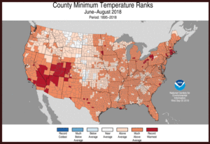
As for the rest of the nation, most experienced a summer of above-average temperatures. The nationally averaged overnight lows were exceptionally warm this summer, 2.5 degrees above average and 0.1 degrees warmer than the previous record set in 2016.
In general, the U.S. summer overnight low temperatures are warming at a rate nearly twice as fast as afternoon high temperatures. The 10 warmest summer minimum temperatures have all occurred since 2002.
Above-average precipitation was observed from the Great Plains to the East Coast, while below-average precipitation was observed for much of the West and parts of the South.


