What role did weather play in the Peshtigo Fire?

An artist's rendering of the Peshtigo Fire, October 8, 1871. As wind-fed fire raged through town, people fled to the river. (Photo credit: The Capital Times Archives)

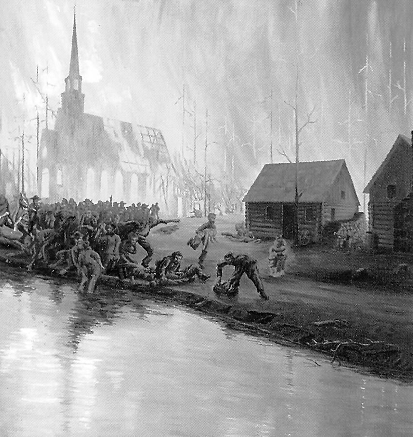
An artist’s rendering of the Peshtigo Fire, October 8, 1871. As wind-fed fire raged through town, people fled to the river. (Photo credit: The Capital Times Archives)

 The Peshtigo Fire was the largest wildfire in U.S. history and occurred on Oct. 8, 1871.

The fire swept through the eastern and western shores of Green Bay, burning more than 1.28 million acres.

The town of Peshtigo — where an estimated 1,200 people died in the blaze — was hit particularly hard, resulting in the blaze being called the Peshtigo Fire.

The fire also destroyed Williamsonville, one of the shingle mill sites of Door County. Tornado Memorial Park is near this former town and commemorates victims who lost their lives fighting a “tornado of fire.”

A fire tornado is a swirl of fire that extends upward from a ground fire.

These vortices can occur over a range of fire sizes but the largest are associated with wildfires. Fire tornadoes are usually 30-200 feet tall and about 10 feet wide. Generally, they last for only a few minutes.

Fires require fuel to burn, air to supply oxygen and a heat source to get the fuel to its ignition temperature. The logging and land clearing practices of the time period, along with the sawmills of the area, provided debris that served as fuel for the Peshtigo Fire.

There were many small fires in the summer of 1871. While instrument weather stations were not available, diaries and other records indicated below-average rainfall over most of the area from June through September 1871. This was likely an important factor in the devastating October fire.

Once a fire starts, weather can influence how it will spread and if it will grow. The important weather factors are temperature, wind and humidity.

Warmer temperatures allow fuels to ignite quickly and low humidity keeps fuel dry and easy to burn. Wind brings oxygen to a fire and can also help it spread. A large fire can generate a wind pattern of its own that can help spread the fire, too.

The fame of the Peshtigo Fire is limited by the better-known Great Chicago Fire, which occurred on the same day, burning up 3.3 square miles of land and killing 300.

Category: Phenomena, Severe Weather, Weather Dangers

Comments Off on What role did weather play in the Peshtigo Fire?

How are hurricane intensities measured?

A GOES East satellite image provided by the National Oceanic and Atmospheric Administration (NOAA) on Thursday shows Hurrican Matthew -- the first Category 5 hurricane in the Atlantic basin since Hurricane Felix in 2007 -- in the Caribbean Sea about 190 miles northeast of Curacao. The category of a hurricane is determined by reconnaissance aircraft flights into the storm along with analysis of satellite images. The satellite approach is led by scientists at the UW-Madison as part of the Cooperative Institute for Meteorological Satellite Studies, or CIMSS (Photo credit: NOAA)

A GOES East satellite image provided by the National Oceanic and Atmospheric Administration (NOAA) on Thursday shows Hurrican Matthew — the first Category 5 hurricane in the Atlantic basin since Hurricane Felix in 2007 — in the Caribbean Sea about 190 miles northeast of Curacao. The category of a hurricane is determined by reconnaissance aircraft flights into the storm along with analysis of satellite images. The satellite approach is led by scientists at the UW-Madison as part of the Cooperative Institute for Meteorological Satellite Studies, or CIMSS (Photo credit: NOAA)

An obvious hurricane threat is its powerful wind, which can blow in a single spot for many hours.

Wind damage is such a hallmark of hurricanes that hurricane intensities are classified by meteorologists using the Saffir–Simpson scale, which rates hurricanes on a scale of 1 to 5 based on the damage their winds would cause upon landfall.

Major hurricanes are those classified as Category 3 and higher on this scale. Category 3 hurricanes have a one-minute sustained wind between 111 mph and 130 mph.

The one-minute sustained winds in a Category 5 hurricane are greater than 155 mph.

The category of a hurricane is determined by reconnaissance aircraft flights into the storm along with analysis of satellite images.

The satellite approach is led by scientists at UW-Madison as part of the Cooperative Institute for Meteorological Satellite Studies, or CIMSS.

This collaboration between the university and the National Oceanic and Atmospheric Administration (NOAA) supports research on weather satellites.

Hurricane Matthew intensified in the Atlantic Ocean this past weekend and will threaten the U.S. mainland this week.

A reconnaissance plane recently measured wind speeds in this storm and those measurements along with the CIMSS analysis led NOAA to list Matthew as a Category 5 storm.

This is the first Category 5 hurricane in the Atlantic basin since Hurricane Felix in 2007.

Fortunately, most hurricanes do not produce the extreme winds linked with the highest category on the Saffir–Simpson scale, but any category storm can do major damage when it hits land.

Flooding from hurricanes causes major damage to shorelines and buildings. The winds in a hurricane push ocean water in front of them. The stronger the wind, the more water is “piled up.”

As the hurricane nears shore, the wind pushes this water inland. This process of wind-induced seawater flooding is called storm surge.

Historically, the storm surge has caused as much as 90 percent of all hurricane-related deaths.

Flooding from rain can also be dangerous.

Hurricane Floyd made landfall in 1999 as a Category 2 storm. Flooding that ensued along the U.S. East Coast accounted for most of the death toll of 57.

Category: Meteorology, Severe Weather, Tropical

Comments Off on How are hurricane intensities measured?

Is Madison breaking any records during the warmest year ever across the globe?

Jennifer Ronquillo, of Madison, plays with her daughters at opening day at the Goodman Pool on June 10 -- Madison's first 90-degree day of the year and the third day of a record-shattering 110-day streak of temperatures at or above 70 degrees. (Photo credit: Amber Arnold, State Journal)

Jennifer Ronquillo, of Madison, plays with her daughters at the Goodman Pool on June 10 — the pool’s opening day, Madison’s first 90-degree day of the year and the third day of a record-shattering 110-day streak of temperatures at or above 70 degrees. (Photo credit: Amber Arnold, State Journal)

Sunday was the 110th consecutive day in Madison with a daily high temperature at or above 70 degrees, shattering the previous longest such streak of 103 days, set in 1998, by seven days.

We are also approaching the record for the number of consecutive days with a daily minimum temperature at or above 45 degrees, set in 2010 when a streak of 128 such days occurred. As of Sunday, this year’s string was at 127. Low temperatures forecast around 45 degrees for Monday through Wednesday could maintain or break that streak.

Though the period of record for minimum temperatures extends back only to 1947, it is conspicuous that 10 of the top 15 such stretches have occurred since 2005. Though such lengthy streaks can result from lucky circumstances — such as a peak of sun on an otherwise cloudy day where the temperature seemed doomed to reach a maximum in the high 60s — it is nonetheless noteworthy that both the streaks have occurred in the warmest year the globe has ever recorded.

Also this past week, the National Snow and Ice Data Center in Boulder, Colorado, reported that the areal extent of the sea ice in the Arctic, which in March of this year recorded its record low maximum extent, was the second lowest on record at the end of the summer (satellite records go back to 1978).

Despite the plethora of local and global data supporting the notion that the earth is warming and that it’s a function of human-induced changes to the chemical composition of the atmosphere, skepticism remains stubbornly widespread. As scientists, we are eager for the debate to become focused on the array of responses society might take in response to the threat rather than continuing to argue over whether or not climate change exists.

Category: Climate, Meteorology, Seasons

Comments Off on Is Madison breaking any records during the warmest year ever across the globe?

Can Pacific hurricanes influence our weather in North America?

A man earing a red helmet, left, climbs on the wreckage of a destroyed structure after a typhoon in Xiamen in southeastern China's Fujian province on Thursday. Typhoon Meranti, labeled the strongest storm so far this year by Chinese and Taiwanese weather authorities, made landfall in southeastern China early Thursday after previously affecting Taiwan. (Photo credit: Chinatopix)

A man earing a red helmet, left, climbs on the wreckage of a destroyed structure after a typhoon in Xiamen in southeastern China’s Fujian province on Thursday. Typhoon Meranti, labeled the strongest storm so far this year by Chinese and Taiwanese weather authorities, made landfall in southeastern China early Thursday after previously affecting Taiwan. (Photo credit: Chinatopix)

Super Typhoon Meranti, the strongest storm of the year, delivered a devastating blow to Taiwan on Tuesday and Wednesday.

The word “typhoon,” used commonly in the west Pacific, is a synonym for “hurricane.” The storm, which intensified from a category 1 to a category 5 hurricane in 24 hours, had estimated sustained winds of 190 mph for nearly a day after reaching that incredible strength.

Though such storms are an annual threat to Taiwan and the neighboring Philippines (a nation that endures more hurricanes each year than any place on Earth), a storm of Meranti’s strength has not made a direct hit on Taiwan since 1959. By the time the storm hit the far southwest tip of the island, the sustained winds had weakened to 115 mph but it still wrought widespread damage to the southern portion of the island.

The storm passed directly over Itbayit in the Philippines so that the small island could be seen in the eye of the storm on satellite images. Meranti subsequently barreled northwestward and made another landfall near Xiamen, China, on Wednesday afternoon with invigorated strength as winds were at an estimated 145 mph, with gusts to 175 mph. As is usually the case with hurricanes, Meranti’s winds weakened after its Chinese landfall, but the storm was still associated with very heavy rains, flashflooding and mudslides.

Though the most intense impacts of the storm are limited to the immediate landfalling areas, the broader atmosphere does respond to the presence of such a powerful hurricane in ways that can eventually affect the weather over North America. The forecast calls for unusual warmth over western Canada at the end of this week that may well have its origin in the interaction of the remnants of Meranti and the jet stream flow over the Pacific Ocean.

Category: Meteorology, Severe Weather, Tropical

Comments Off on Can Pacific hurricanes influence our weather in North America?

How does Hurricane Hermine measure up?

Water from Roanoke Sound pounds the Virginia Dare Trail in Manteo, NC, Saturday, as Tropical Storm Hermine passes the Outer Banks. Hermine lost hurricane strength over land but intensified along the Atlantic Coast. (Photo credit: Tom Copeland, Associated Press)

Water from Roanoke Sound pounds the Virginia Dare Trail in Manteo, NC, Saturday, as Tropical Storm Hermine passes the Outer Banks. Hermine lost hurricane strength over land but intensified along the Atlantic Coast. (Photo credit: Tom Copeland, Associated Press)

On Friday Hurricane Hermine made landfall in Florida, making it the first to make landfall in the state in more than a decade.

Hermine, which weakened to a tropical storm shortly after landfall as is commonly the case with weak hurricanes, was poised to redevelop and pose a threat to the Mid-Atlantic states and possibly southern New England into the middle of the week.

Eighty-one years ago, nearly to the day, the famous Labor Day Hurricane of 1935 struck Florida with greater intensity than any other landfalling hurricane in the country’s history.

While Hermine had sustained winds of about 75 mph and dropped nearly 17 inches of rain in the Tampa/St. Petersburg area, the Labor Day Hurricane made landfall with sustained winds near 185 mph.

Both storms developed within days of Sept. 12, the date of the average peak frequency for such storms in the Atlantic Basin. Though the number of tropical cyclones in an average year numbers in the low teens, these storms are deserving of attention because they can wreak enormous damage to life and property.

They also play a substantial role in ventilating the tropical ocean and mixing heat from the tropics, where an annual surplus accumulates, to the high latitudes where an annual deficit stands in need of remedy.

It may seem surprising given our location in the middle of the North American continent, but hurricane research, employing both satellite observations and theoretical advances, at UW-Madison has led the way toward improved understanding and forecasting of these powerful storms.

Category: Meteorology, Severe Weather, Tropical

Comments Off on How does Hurricane Hermine measure up?