Why withdraw from the Paris Climate Accord?

President Trump’s decision to withdraw the U.S. from the Paris Climate Accord last Thursday is a disheartening blow to the longstanding idea that sound science should play a role in the formation of public policy in our country.

This notion, in fact, was central to the creation of the National Academy of Sciences by the first Republican president, Abraham Lincoln in 1863. Lincoln and the Congress charged the Academy with providing independent, objective advice to the nation on matters related to science and technology.

The National Academy and the overwhelming majority of climate scientists agree that human activity is a major contributing factor to global climate change – there is essentially no disputing this fact. Despite this robust consensus, which serves as the motivation for 195 other nations to join forces in committing to a cleaner energy future for the benefit of future generations, our own government has committed to skepticism, short-sightedness and ignorance (literally, “the act of ignoring”)..

It seems distressingly untenable to assert American exceptionalism on the one hand while on the other resigning to retreat from a unique and urgent global challenge. This is not a traditionally American position, it is an embarrassing shirking of responsibility, an unforced error motivated by ideology, not by reasoned judgment. Our country, in a complicated world where reason has long been one of its guides, has always done better than this.

Category: Climate, Uncategorized

Comments Off on Why withdraw from the Paris Climate Accord?

Is the weather nicer on Memorial Day or Labor Day?

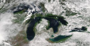
Suomi NPP VIIRS view of the Great Lakes Region on Memorial Day Weekend 2017 (5/27)

Memorial Day traditionally marks the beginning of the summer, while Labor Day marks the end.

People are bound to have their own recollections and opinions about which weekend more reliably delivers agreeable weather here in southern Wisconsin, and those opinions can be colored by many non-meteorological influences.

If forced to opine on this question while sticking to strictly meteorological factors, we would suggest that Labor Day weekend’s weather is more reliably summerlike.

The reason for this comes directly from the fact that Memorial Day comes as winter is ending and Labor Day as winter approaches.

As the winter ends, the entire Northern Hemisphere gradually warms up and the leftover cold air from the polar regions is gradually bled away to lower latitudes where it disappears.

This “bleeding” of cold air occurs in distinct blobs, known as cutoff lows. It is verifiable that there are many more cutoff lows in the hemisphere in May than in September.

These cutoffs can sometimes remain over a location for days at a time and negatively impact the local weather by engendering conditions that favor the development of thundershowers and persistent clouds, not to mention below normal temperatures. Our cooler weather early last week was related to such an event.

Since these features are more common in May, the weather is more prone to these undesirable unsettled periods this month than in September.

Category: Meteorology, Seasons

Comments Off on Is the weather nicer on Memorial Day or Labor Day?

Did someone predict the recent Wisconsin tornado?


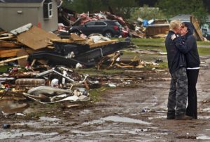
Ron Bloomberg, who witnessed victim and neighbor Eric Gavin’s body being recovered, embraces his girlfriend as he returns to his home in Chetek, Wis., after a tornado flattened a trailer park and nearby trees. (Richard Tsong-Taatarii/Star Tribune via AP)

We cannot yet forecast tornado occurrence with any accuracy. One problem is the small size of a tornado, which is a narrow column of strong winds that rotate around a center of low pressure.

Over the last 60 years, forecasts of the development of large-scale low-pressure systems, which often organize the ingredients needed to form a tornado, have steadily improved. Because of these advances, meteorologists are better able to predict those conditions a few days in advance, enabling forecasters to identify counties where there is a threat of severe weather sometimes as many as three days in advance. Two days in advance of the recent EF-2 tornado (later upgraded to EF-3) that hit southeastern Polk County, the National Weather Service’s Storm Prediction Center’s convective outlook issued a slight-risk for the area.

For a thunderstorm to produce a tornado requires warm humid air near the surface with cold dry air above. These conditions make the atmosphere very unstable, in the sense that once air near the ground is forced upward, it ascends freely and quickly (like a helium balloon), cools as it expands and forms a storm. Severe thunderstorm conditions also include a layer of hot, dry air between the warm, humid air near the ground and the cool dry air aloft. This hot layer acts as a lid that allows the sun to further heat the warm, humid air — making the atmosphere even more unstable. In the central U.S., such air is created over the plateau of Mexico and sent northeastward over the Great Plains.

To form a tornado, the host thunderstorm must also rotate. This happens in a storm when wind at the ground is moving in a different direction and speed than the air above. The change in wind speed and direction with height is known as wind shear. Both wind shear and atmospheric instability are needed for tornado formation.

Recent advanced models have been able to simulate development of a tornado, a first step to better predictions. Advances in radar technologies have helped to identify storms that are producing a tornado, or about to produce one. Based on observations from such advanced technologies, the Storm Predication Center (SPC) issued a warning about one hour before the Polk County tornado, and the NWS issued a tornado warning about 10 minutes before the first sighting of a funnel cloud.

Steve Ackerman and Jonathan Martin, professors in the UW-Madison department of atmospheric and oceanic sciences, are guests on WHA radio (970 AM) at 11:45 a.m. the last Monday of each month.

Category: Meteorology, Severe Weather

Comments Off on Did someone predict the recent Wisconsin tornado?

Is the weather in Madison more extreme than other locations in the U.S.?

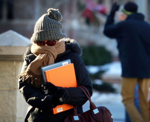
Spend an entire year in Madison, and you’ll likely experience a huge swing in temperatures and humidity, thanks to the area’s continental climate. (Photo credit: John Hart, State Journal archives)

Sitting nearly in the middle of the vast North American continent, Madison has what is known as a continental climate. Continental climates are characterized by large annual extremes in temperature and humidity as well as very distinct seasons.

The continental nature of Madison’s climate is what makes a year’s worth of weather in Madison usually a lot more varied than a year’s worth in, say, Seattle.

There is an astounding 144-degree difference between the all-time highest temperature in Madison (107 degrees on July 13, 1936) and the all-time lowest (37 below zero on Jan. 31, 1951). In addition, the amount of water vapor in the air can range from the barely detectable level in the midst of a deep winter cold spell to as much as 3.5 percent of every breath you take during a severe July heat wave.

No matter what the season, the vast majority of the invisible water vapor in the atmosphere is contained in the lowest mile or two from its source at the surface.

At any given time, the Earth’s atmosphere contains 37.5 million billion gallons of water vapor – enough to cover the entire surface of the planet with 1 inch of rain if condensed. This amount is recycled, through evaporation powered by the sun, 40 times each year in what is known as the hydrologic cycle.

In each of these 40 cycles, enough energy is expended to power the United States – the largest consumer of energy in the world – for 3,441 years, a truly astounding amount of energy.

Category: Climate, Seasons

Comments Off on Is the weather in Madison more extreme than other locations in the U.S.?

Is the California drought over?

Drought in the United States has been assessed by a number of different measures over the last several decades.

One of the older such measures is the Palmer Drought Index introduced in 1965. The Palmer Index is based on a supply-and-demand model of soil moisture. Of the two, supply is easier to calculate, as it is tied so obviously to precipitation. The demand side of the model is more complicated as it depends on processes such as evapotranspiration — the loss of water from the soil through direct evaporation and transpiration from plants — and the recharge of soil moisture by a variety of processes.

The Palmer Index approximates this complicated nest of processes based on a formula that is based on recent temperature and precipitation. It is quite effective in assessing long-term drought but suffers in making statements on shorter time scales.

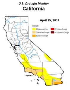
In 1999, the National Oceanic and Atmospheric Administration and the U.S. Department of Agriculture developed the weekly U.S. Drought Monitor. By this measure, drought in the U.S. fell to a record low this past week with only 6.1 percent of the contiguous 48 states experiencing drought conditions. The previous record low according to this measure was 7.7 percent in July 2010.

Conversely, the most extensive drought in the 17-plus-year history of the Drought Monitor occurred in September 2012 when drought conditions of one degree or another were spread over 65.5 percent of the lower 48 states.

Most notable currently is the official end of the years-long drought in California that was announced last week. The past winter was quite wet and has filled reservoirs in much of California to capacity. In fact, there are now fears in certain parts of California that the spring snowmelt will induce flooding.

Steve Ackerman and Jonathan Martin, professors in the UW-Madison department of atmospheric and oceanic sciences, are guests on WHA radio (970 AM) at 11:45 a.m. the last Monday of each month.

Category: Climate, Meteorology

Comments Off on Is the California drought over?