When does fall begin?

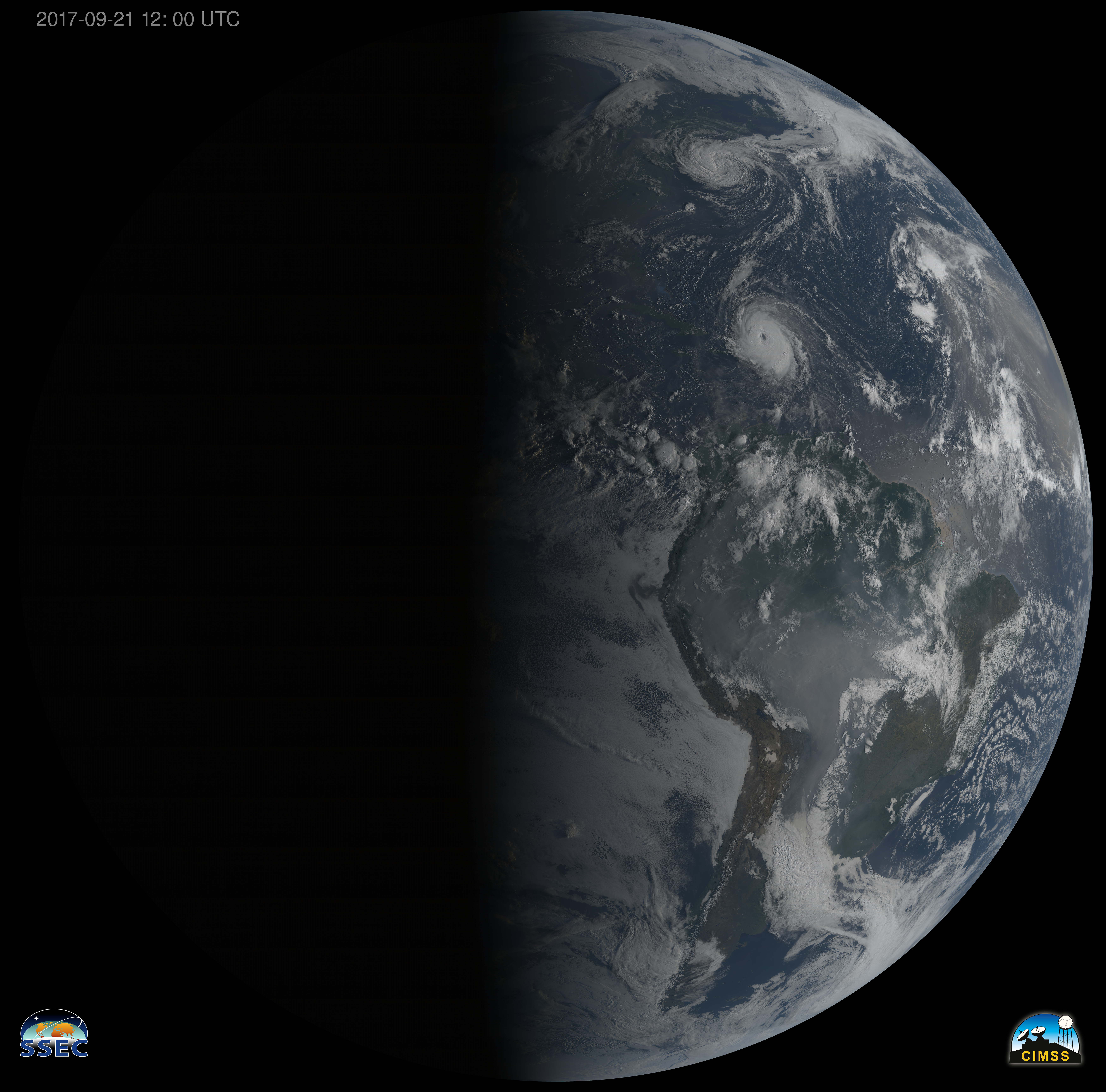
GOES-16 True Color image from September 21, 2017. Credit: Kaba Bah, CIMSS/SSEC
(click to enlarge)

Even the least observant person has probably recognized by now that the days are growing shorter.

In fact, on Friday at 3:02 p.m., we will reach the autumnal equinox and the night will be as long as the day for the first time since late March.

At the North Pole, the situation is more dire, as Saturday morning will be the first of 182 straight days during which the Sun will not rise there! As each day goes by, the portion of the polar regions that gets no sunlight continues to expand until late December. Thus, larger and larger areas of the high latitudes have continual night over the next 3 months.

This circumstance drives the production of increasingly extensive cold air masses near the surface which gradually begin to spread southward as the season progresses.

In North America, the cold air production during this period can be enhanced if early season snow falls over wide areas of northwestern Canada because air over a snow-covered surface can get colder overnight than air over a bare surface.

So, how cold the fall and early winter will be in Madison can be strongly connected not only to when the snow begins to fall to our far northwest but also how much actually falls.

Keep an eye on northwest Canada!

Steve Ackerman and Jonathan Martin, professors in the UW-Madison department of atmospheric and oceanic sciences, are guests on WHA radio (970 AM) at 11:45 a.m. the last Monday of each month.

Category: Meteorology, Seasons

Comments Off on When does fall begin?

What are the leading threats from hurricanes?

A woman and child use a blanket as protection from wind and rain as they walk in Caibarien, Cuba, on Friday. Hurricane Irma battered Cuba on Saturday with deafening winds and unremitting rain, pushing seawater inland and flooding homes before taking aim at Florida.(Photo credit: Desmond Boyland, Associated Press)

With all the news about hurricanes over the past couple of weeks we’ve been asked a lot of questions about the various threats posed by these storms.

Hurricane Harvey is a clear example of the damage that long-duration heavy rains can inflict. Hurricane Irma provides an example of the destructive power of the winds associated with these storms.

Objects in the path of strong winds bear what is known as a wind load. This wind load is the product of the area of the object times the wind pressure (equal to 0.00256 x windspeed2) times a laboratory-determined drag coefficient. For a wall the drag has a value of 2 while for a telephone pole it is only 0.8. A 10-foot by 20-foot wall subjected to 150 mph winds like those delivered by Irma in some locations would feel a wind load of 8.7 tons.

The most effective protection against structural damage to a house in the face of such winds is to shutter the windows. The primary reason to do so is to keep the strong winds outside of the dwelling. If a window breaks and the wind can come rushing in a lot more damage can be done to the structure.

The storm surge associated with hurricanes results from the piling up of water ahead of the storm by its strong winds. It turns out that the depth of the storm surge is best predicted by the strength of the storm about 18 hours before it makes landfall. This is because any changes in the intensity of the winds in those last 18 hours have too little time to impact the mountain of water that has already been produced.

Steve Ackerman and Jonathan Martin, professors in the UW-Madison department of atmospheric and oceanic sciences, are guests on WHA radio (970 AM) at 11:45 a.m. the last Monday of each month.

Category: Severe Weather, Tropical, Weather Dangers

Comments Off on What are the leading threats from hurricanes?

Why is lightning white?

Lightning illuminates the sky as Texas State warms up in Doak Campbell Stadium in Tallahassee, Fla., prior to an NCAA football game against Florida State on Sept. 5, 2015. The intensity of all the colors in lightning tends to saturate our eyes, leading us to perceive the color white. (Photo credit: Mark Wallheiser, Associated Press)

Lightning is a huge electrical discharge.

Static charges form in a storm composed of ice crystals and liquid water drops. Turbulent winds inside the storm cause particles to rub against one another, causing electrons to be stripped off, making the particles either negatively or positively charged.

The charges get grouped in the cloud, often negatively charged near the bottom of the cloud and positively charged up high. This is an electric field and because air is a good insulator, the electric field becomes incredibly strong. Eventually a lightning bolt happens and the flow of electrons neutralizes the electric field.

This flow of electrons through the lightning bolt creates a very hot plasma, as hot as 50,000 degrees, that emits a spectrum of electromagnetic energy. Some of this radiation is in the form of radio waves and gamma rays.

Instruments that measure these electromagnetic waves allow us to detect lightning bolts that are very far away. Visible light is also part of the spectrum of energy.

At these temperatures, laws of physics state that most of the visible light will be at a wavelength perceived as the color blue, although all wavelengths will be emitted.

The notion of color applies to our perception of what we see, not to the light itself. When we talk about the color of light, we really mean the color we sense with our eyes and then interpret with our mind.

Thus, while the peak energy is at blue wavelengths, the intensity of all the colors tends to saturate our eyes, leading us to perceive the color white – which includes all wavelengths in the visible spectrum.

Over the last 20 years scientists have discovered that lightning also shoots upward out of the top of thunderstorms into the upper atmosphere. These lightning types have distinctive colors, including red sprites and blue jets.

Category: Meteorology, Phenomena, Severe Weather

Comments Off on Why is lightning white?

Is UW-Madison involved in hurricane forecasting?

GOES-16 animation of Hurricane Harvey showing Clean Window IR (10.3 µm) and City Lights Background at night, True Color Imagery during the day, 1100-1900 UTC on 25 August 2017 (Photo credit: Space Science and Engineering Center, UW-Madison)

Hurricane Harvey is the first hurricane to make landfall in the United States since Wilma hit Florida in October 2005.

Harvey made landfall early Saturday morning as a Category 4 storm with estimated sustained winds of 130 mph and gusts to 150 mph.

Even in the face of these extreme winds, however, the largest fraction of the widespread damage associated with the storm is likely to be a direct result of the almost unimaginable amounts of rain that will fall with its passage across eastern Texas and Louisiana.

By the time the storm’s weakened remnants are forecast to leave the region on Wednesday, a number of locations are likely to have received more than 2 feet of rain, and some may even see 4 feet!

Needless to say, the ground cannot effectively absorb that much water in so short a time and so widespread flooding will be the rule in southeast Texas.

Millions of people will be adversely affected by this event, and it is only the beginning of what has been predicted to be a fairly vigorous Atlantic hurricane season.

It may surprise you to know that UW-Madison is a major contributor to national efforts to monitor and predict these powerful storms.

The Cooperative Institute for Meteorological Satellite Studies (CIMSS) has a research group within it dedicated to processing satellite remote observations so that they can be used in computer-based forecasts of these storms.

Since hurricanes develop over the vast tropical oceans, these satellite observations are the most comprehensive set of measurements available for these forecast models.

Without this Wisconsin connection, our ability to forecast these mercurial storms would be substantially less successful and many more people would be imperiled by their approach.

Steve Ackerman and Jonathan Martin, professors in the UW-Madison department of atmospheric and oceanic sciences, are guests on WHA radio (970 AM) at 11:45 a.m. the last Monday of each month.

Category: Meteorology, Severe Weather, Tropical

Comments Off on Is UW-Madison involved in hurricane forecasting?

Why is the sky blue?

During a total eclipse, when the full sun is covered by the moon, we only see light on the horizon that is scattered in our direction. (Photo credit: NASA)

All the attention of today’s eclipse has raised interest in the sky’s color.

To understand why the sky is blue, we need to understand a little about light. Light is a form of electromagnetic energy. This form of energy does not need matter to propagate.

We can characterize this energy by its wavelength — the distance along a wave from one crest to another. Our eyes are sensitive to light with wavelengths between approximately 0.4 to 0.7 microns (one micron is a millionth of a meter or one one-hundredth the diameter of a human hair). Blue colors have wavelengths between about .455 and .492 microns, while red colors have longer wavelengths between .622 and .780 microns.

When light beams interact with particles suspended in air, the energy can be scattered or absorbed. Energy that is scattered causes a change in direction of the light path. The amount of light that is being scattered is a function of the size of the particle relative to the wavelength of the light falling on the particle.

Particles that are tiny compared to the wavelength of the light scatter selectively according to wavelength. While all colors are scattered by air molecules, violet and blue are scattered most. The sky looks blue, not violet, because our eyes are more sensitive to blue light (the sun also emits more energy as blue light than as violet).

At sunset and sunrise, the sunlight passes through more atmosphere than during the day when the sun is higher in the sky. More atmosphere means more molecules to scatter the violet and blue light. If the path is long enough all of the blue and violet light gets redirected out of your line of sight, while much of the yellow, orange and red colors continue along the undeviated path between your eye and the sun. This is why sunsets often are composed of yellow, orange and red colors.

During a total eclipse, when the full sun is covered by the moon, we only see light that on the horizon that is scattered in our direction.

Category: Meteorology, Phenomena

Comments Off on Why is the sky blue?