How does frost form?

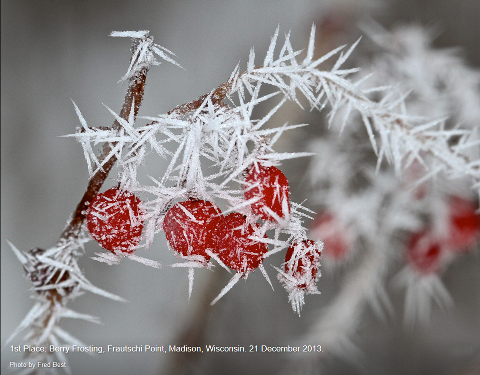
Frost on Berries, Frautschi Point, Madison Wisconsin. Credit: Fred Best

Frost on objects is just water vapor in the air that has deposited itself as ice onto a surface. Frost forms on objects close to the ground, such as blades of grass.

At night, a blade of grass loses energy by emitting radiation (a non-lethal kind) while it gains energy by absorbing the energy emitted from surrounding objects. Under clear nighttime skies, objects near the ground emit more radiation than they receive from the sky, and so a blade of grass cools as its energy losses are greater than its energy gains. If the temperature of a grass blade gets cold enough and there is sufficient water vapor in the environment, frost will form on the grass.

Overnight cooling of the air near the ground causes morning frost on grass and car windshields. Frost will form on a surface only where the temperature is at or below freezing. The observed air temperature may be higher than 32 degrees, since those air temperature observations are taken at about 4 feet above the ground, where it can be warmer than the ground.

You may notice that frost forms in an open field but not under a tree. Trees emit more radiation toward the ground than does the clear sky. Energy losses at the ground under the tree are therefore less than those of the grass in the open field. The grass in the open field cools faster and reaches the frost point before the grass blades under the tree.

Steve Ackerman and Jonathan Martin, professors in the UW-Madison department of atmospheric and oceanic sciences, are guests on WHA radio (970 AM) at 11:45 a.m. the last Monday of each month.

Category: Meteorology, Seasons

Comments Off on How does frost form?

Do trees need cold weather?

Extreme cold weather can kill trees, and cold weather at the wrong time can damage trees. For example, a warm February and March in Michigan in 2012 brought early blooms to apple trees that then were killed by an April frost.

Some trees require cool temperatures, such as some fruit trees (peaches, cherries and blueberries) and nuts (almonds). Cold air along with less sunlight that comes with winter halts tree growth, preparing the tree to withstand freezing temperatures and then resume their growing the following spring.

The amount of time the temperature is between 32 and 45 degrees F is called “chill hours.” If these fruit and nut trees do not get their required number of chill hours, buds are delayed and the fruit can be small and underdeveloped.

You may have noticed the small crop of Georgia peaches this year. That is because the 2016 and 2017 Georgia winters were warm. As a result, the region lost as much as 85 percent of its peach crop. If winters continue to warm, these fruit trees will be less productive.

Georgia was not the only state with a chill hour deficit last year. Most of the U.S. had fewer chill hours than average.

Farmers have always been dependent on good weather and have learned to adapt to bad crop weather. Warming winters as a result of climate change bring new challenges.

Category: Meteorology, Seasons

Comments Off on Do trees need cold weather?

What’s up with all the wild weather?

Another week of destructive weather around our country culminated in the passage of Hurricane Maria over the island of Puerto Rico on Wednesday of last week. Some of the rainfall totals from automated stations on the island were of truly biblical proportions.

Though still subject to verification and a check on accuracy, 12.20 inches of rain fell in one hour at Gurabo Abajo, one of several stations on the southwest side of El Yunque, the high mountainous area in the northeast.

Such unimaginable rainfall is consistent with the swelling of the Rio Grande de Manati and Rio de la Plata (at least 10 to 16 feet above flood stage) on the island in the immediate wake of Maria’s passage. It is likely that the full extent of the flooding will not be known for many days, perhaps even weeks.

Meanwhile, here at home we have experienced a sudden resurgence of summer with last Wednesday’s high of 91, only the third high at or above 90 all summer, as both the daily record and the latest day in Madison history to be at 91. The old record for September 20 was 89 set last in 1908 after occurring both in 1891 and 1895.

Record highs on both Friday (91) and Saturday (92) gave us three records in four days — the first record highs registered in September in Madison since 1978! With our 92 on Saturday, the warmest day of this year ironically fell on the first full day of autumn! What a month!

Category: Meteorology, Seasons, Tropical

Comments Off on What’s up with all the wild weather?

When does fall begin?

GOES-16 True Color image from September 21, 2017. Credit: Kaba Bah, CIMSS/SSEC
(click to enlarge)

Even the least observant person has probably recognized by now that the days are growing shorter.

In fact, on Friday at 3:02 p.m., we will reach the autumnal equinox and the night will be as long as the day for the first time since late March.

At the North Pole, the situation is more dire, as Saturday morning will be the first of 182 straight days during which the Sun will not rise there! As each day goes by, the portion of the polar regions that gets no sunlight continues to expand until late December. Thus, larger and larger areas of the high latitudes have continual night over the next 3 months.

This circumstance drives the production of increasingly extensive cold air masses near the surface which gradually begin to spread southward as the season progresses.

In North America, the cold air production during this period can be enhanced if early season snow falls over wide areas of northwestern Canada because air over a snow-covered surface can get colder overnight than air over a bare surface.

So, how cold the fall and early winter will be in Madison can be strongly connected not only to when the snow begins to fall to our far northwest but also how much actually falls.

Keep an eye on northwest Canada!

Steve Ackerman and Jonathan Martin, professors in the UW-Madison department of atmospheric and oceanic sciences, are guests on WHA radio (970 AM) at 11:45 a.m. the last Monday of each month.

Category: Meteorology, Seasons

Comments Off on When does fall begin?

What are the leading threats from hurricanes?

A woman and child use a blanket as protection from wind and rain as they walk in Caibarien, Cuba, on Friday. Hurricane Irma battered Cuba on Saturday with deafening winds and unremitting rain, pushing seawater inland and flooding homes before taking aim at Florida.(Photo credit: Desmond Boyland, Associated Press)

With all the news about hurricanes over the past couple of weeks we’ve been asked a lot of questions about the various threats posed by these storms.

Hurricane Harvey is a clear example of the damage that long-duration heavy rains can inflict. Hurricane Irma provides an example of the destructive power of the winds associated with these storms.

Objects in the path of strong winds bear what is known as a wind load. This wind load is the product of the area of the object times the wind pressure (equal to 0.00256 x windspeed2) times a laboratory-determined drag coefficient. For a wall the drag has a value of 2 while for a telephone pole it is only 0.8. A 10-foot by 20-foot wall subjected to 150 mph winds like those delivered by Irma in some locations would feel a wind load of 8.7 tons.

The most effective protection against structural damage to a house in the face of such winds is to shutter the windows. The primary reason to do so is to keep the strong winds outside of the dwelling. If a window breaks and the wind can come rushing in a lot more damage can be done to the structure.

The storm surge associated with hurricanes results from the piling up of water ahead of the storm by its strong winds. It turns out that the depth of the storm surge is best predicted by the strength of the storm about 18 hours before it makes landfall. This is because any changes in the intensity of the winds in those last 18 hours have too little time to impact the mountain of water that has already been produced.

Steve Ackerman and Jonathan Martin, professors in the UW-Madison department of atmospheric and oceanic sciences, are guests on WHA radio (970 AM) at 11:45 a.m. the last Monday of each month.

Category: Severe Weather, Tropical, Weather Dangers

Comments Off on What are the leading threats from hurricanes?