Can weather satellites see the fires in California?

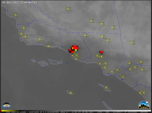
GOES-15 IR detection of California wildfires
on 12/5/17, from the CIMSS Satellite Blog.
(click to animate)

Sensitive instruments on some weather satellites can see the fires, but only at night. They do not see individual trees burning but they detect that a region is on fire. We can see the flames during the night because it’s dark and that increases contrast. During daytime, solar illumination reduces this contrast and thus detectability.

The instruments onboard satellites can detect byproducts of the fires 24 hours a day. For example, during the daytime, observations at wavelengths associated with the color blue can detect the smoke from the fires. They can pinpoint the origin of the smoke, and thus the fires.

Satellites can track the smoke as it is transported away from the fires. The smoke can be transported by the winds to the ground and become an air quality issue. In dense concentrations the smoke can have health impacts for those with asthma conditions.

Instruments onboard satellites also can detect the heat emitted by the fires. These instruments make observations at infrared wavelengths — wavelengths our human eyes cannot see — and work during the daytime and nighttime. At these wavelengths, smoke is transparent so even if the smoke is thick, the instruments can see through the smoke to the heat generated by the flames.

The new geostationary satellites, ones that appear to be fixed above Earth, are used to detect and monitor the fires. Observations can be made every 30 seconds, which allows forecasters to track the direction the fire moves and also the intensity of the fire. This is very useful information in fighting the fires. Satellite measurements can also be used to estimate how much material is being consumed by the fires.

Once the fires are extinguished, satellites can measure the size of the burn scar. Over time we can observe how new vegetation grows into the burned area and the ecological recovery.

Steve Ackerman and Jonathan Martin, professors in the UW-Madison department of Atmospheric and Oceanic Sciences, are guests on WHA radio (970 AM) at 11:45 a.m. the last Monday of each month.
Category: Uncategorized

Comments Off on Can weather satellites see the fires in California?

Will the roller coaster of early winter temperatures continue?

The past month was very clearly split into two nearly equal but opposite halves temperature-wise.

The first 15 days of November were routinely, though not exclusively, below normal with 10 days falling into that category. In fact, the eight days from Nov. 6 to Nov. 13 were consecutively below normal, with the morning low of 9 degrees on Nov. 10 setting a daily record.

The early cold left us averaging 5.1 degrees colder than normal through November 15. Only three additional below-normal days occurred after the halfway point. Remarkably, beginning on Nov. 23, the month ended with eight consecutive days of above-normal temperatures, including the record high of 64 degrees on Nov. 24.

The warm second half of the month averaged 3.9 degrees above normal so, overall, November was just 0.6 degrees colder than usual even after its brutally cold start.

This latest extended period of unusual warmth will be over after today, however. Forced by the influence of successive strong cyclones in the Gulf of Alaska at the end of November, the mid-tropospheric flow over North America has transformed quickly. We are now poised to intercept a cold northwesterly flow originating in far northwestern Canada.

Overnight into Tuesday, temperatures will plummet as we head into an extended and exceptional cold snap to start December. The lack of snow cover will mitigate this upcoming chill to a great extent, but it is likely we will not enjoy another warm day like today for some time. Enjoy it while you can.

Steve Ackerman and Jonathan Martin, professors in the UW-Madison department of atmospheric and oceanic sciences, are guests on WHA radio (970 AM) at 11:45 a.m. the last Monday of each month.
Category: Uncategorized

Comments Off on Will the roller coaster of early winter temperatures continue?

How are the National Weather Service and Wisconsin connected?

The roots of our National Weather Service have a distinctive Wisconsin flavor. Professor Increase A. Lapham, a University of Wisconsin professor at the time of the founding of the university, was the first official Smithsonian Institution weather observer in Milwaukee and long argued for the establishment of a national weather observation network.

With the election of President Ulysses S. Grant in November 1868, Lapham and Rep. Halbert Paine, the U.S. congressman from Milwaukee, thought the time was right to pursue this goal. Grant had developed a keen sense of the influence of weather on military operations through his experiences in the Civil War.

On Feb. 2, 1870, Paine introduced a Joint Congressional Resolution that tasked the Secretary of War “… to provide for taking meteorological observations at the military stations in the interior of the continent and at other points in the States and Territories … and for giving notice on the northern [Great] lakes … of the approach and force of storms.”

Congress passed the resolution with little hesitation and a week later, on Feb. 9, 1870, President Grant signed it into law – effectively establishing the first iteration of the National Weather Service (then called the U.S. Army Signal Service). Operation of the Signal Service began Nov. 1, 1870, and one week later, Lapham issued the first high wind warning for the Great Lakes from Chicago. The forecast was accurate and was credited with saving considerable property and protecting lives.

The Wisconsin connection to the National Weather Service continues to this day, as the current director of the NWS is a UW-Madison graduate, Dr. Louis Uccellini.

NWS Director Louis Uccellini awards ‘Storm-Ready’ plaque to UW-Madison Chancellor Becky Blank in 2015. Photo credit: Bill Bellon

Steve Ackerman and Jonathan Martin, professors in the UW-Madison Department of Atmospheric and Oceanic Sciences, are guests on WHA radio (970 AM) at 11:45 a.m. the last Monday of each month.

Category: Meteorology

Comments Off on How are the National Weather Service and Wisconsin connected?

Who is Increase Lapham?

Portrait of Increase Lapham (Photo credit: Wisconsin Historical Society archives)

Many consider Increase Lapham to be one of Wisconsin’s greatest scientists.  Though never formally educated, Lapham demonstrated an early talent for topographical sketching and became an engineer and surveyor of canals in the 1830s.

He was born in Palmyra, New York, on March 7, 1811, the fifth of 13 children in a poor Quaker family.  Early in 1836, he was invited to Milwaukee as chief engineer in charge of building the Rock River Canal (which was never built).

Lapham made contributions in many scientific endeavors including cartography, geology, ecosystems science, and Native American history of Wisconsin.  One of his foremost interests was weather and climate.

He sent frequent reports of maritime casualties to Milwaukee’s congressional representative, Gen. Halbert Paine, which eventually prompted Paine to introduce a joint resolution on Feb. 2, 1980, requiring the Secretary of War to “provide for taking meteorological observations at the military stations in the interior of the continent … and for giving notice on the northern lakes (the Great Lakes) … of the approach and force of storms.”

The resolution passed and one week later, President Ulysses S. Grant, who personal experiences during the Civil War had long ago convinced him of the utility of meteorological information for military activities, signed it into law.

On Nov. 1, 1870, the United States Army Signal Service — what would grow to become the National Weather Service — began operations.

On Nov. 8, 1870, Dr. Increase Lapham, who had been the catalyst for the formation of the Signal Service, issued its first official storm warning for the waters of Lake Michigan.

Category: Uncategorized

Comments Off on Who is Increase Lapham?

Why do bridges ice before the road?

Compared to a roadway, a bridge has more surface area to exchange energy with the atmosphere, and thus will cool down to the air temperature — and freeze — quicker. (Photo credit: Beaver Dam Daily Citizen archives)

Living in a cold climate, we are used to seeing signs that say “bridge freezes before road.”

The fundamental reason is that a bridge hangs above the ground, while the roadway rests on the ground. Water on a road or bridge will freeze once the surface becomes cold enough. So, the bridge must cool faster than the roadway.

Whether something warms or cools is related to its energy gains and losses. So, as you stand facing an evening bonfire, your front warms because it gains more energy than it loses, while your back cools as it loses more energy to the cooler night air than it gains.

The energy losses from a bridge occur along the top surface and also along its side and bottom. Compared to a roadway, a bridge has more surface area to exchange energy with the atmosphere, and thus will cool down to the air temperature quicker.

Many bridges are made of metal and concrete, both of which are good heat conductors. Thus, when cold air comes in contact with the bridge surfaces, heat is quickly transferred from the bridge to the colder air, cooling the bridge and its surfaces.

A roadway also loses heat from its surface to the cold air above. However, the road surface also gains energy from the ground. So, while the roadway will cool down, it does not cool as fast because of the energy gains it gets from the warmer ground below. Because of those extra energy gains, the roadway cools more slowly and doesn’t form ice as quickly as the bridge.

Category: Uncategorized

Comments Off on Why do bridges ice before the road?