What was the ring around the sun last week?

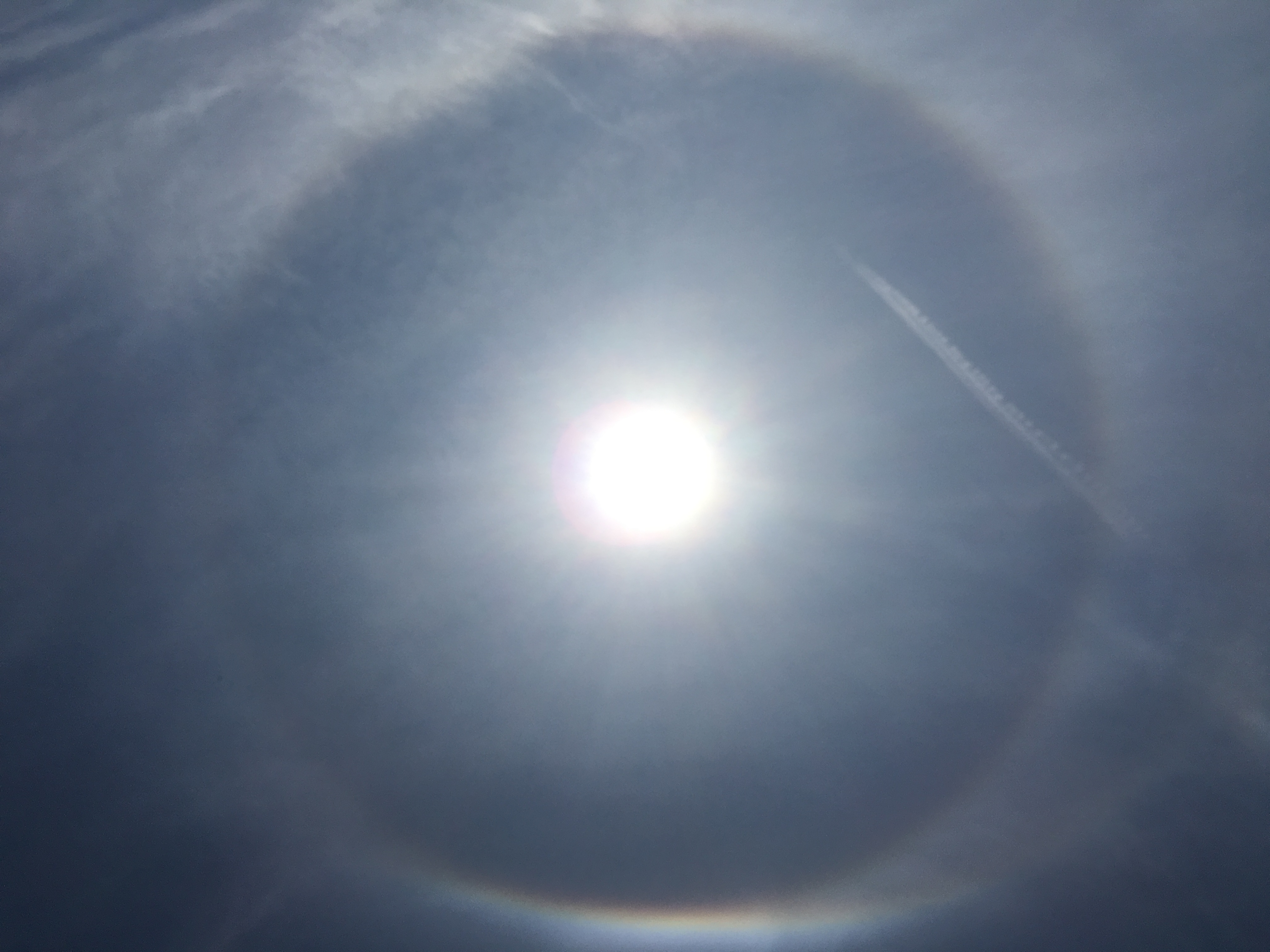
Halo over Madison, Wisconsin on April 26th.
Photo Credit: Doug Ratcliff, SSEC

Last week there was a ring around the sun for much of the day. This ring is called a halo and is caused by ice crystals interacting with sunlight.

A halo is a whitish ring that encircles but does not touch the sun. It can also have some color; the most discernible is a faint red tint around the inside of the halo. It is an optical phenomenon that owes its existence to the bending of light by ice crystals, much like the “rainbow crystals” you may hang in your sunlit windows.

The most commonly observed halo is the 22-degree halo. This halo encircles the sun at about a hand’s width from the center of the sun, if your arm is fully extended. Small column-like ice crystals form the halo. Light rays enter a crystal, bend or refract, and then refract again as they exit the crystal.

Because the crystals are randomly oriented in space, there are many different directions from which light rays can enter the crystals. Because of the optical properties of ice, more light rays are refracted at a 22-degree angle than at any other, producing the concentration of light known as the halo.

If you were lucky, you may have seen shiny, colored regions at either side of the sun. These are called sundogs, and are another optical effect caused by refraction.

Sundogs appear because ice crystals in the shape of hexagons drift downwards, oriented parallel to the ground. The sunlight passing through the crystal refracts and exits the crystal’s side face and generates the sundog.

Steve Ackerman and Jonathan Martin, professors in the UW-Madison department of atmospheric and oceanic sciences, are guests on WHA radio (970 AM) at 11:45 a.m. the last Monday of each month.
Category: Meteorology, Phenomena

Comments Off on What was the ring around the sun last week?

Has the cold weather this month caused any positive effects?

Rick Fink of Mayville blows snow April 19 in front of his tractor and pulls his planter behind, for fun!
(Photo credit: Ryan Andres, Agri-View)

As a very unusual month of April comes to a close, it may be of interest to note some of its ramifications across the country, both good and bad.

Among the headaches that have resulted from the unrelenting wintry nature of the month was the cancellation of 28 Major League Baseball games through the late part of the month — an all-time record.

To put this number in perspective, 2016 suffered only 25 cancellations through the entire season!

And, of course, a large number of these cancellations were a result of cold and snow.

Other ramifications of the weather this month include a late start for farmers, some of whom are as much as two weeks behind as a consequence of low soil temperatures brought on by the persistent cold.

On the other hand, it may be somewhat comforting to know that the unseasonable coolness of this month has also had a few positive aspects to it.

To this point in the month, not a single tornado has been reported in Oklahoma — the longest the state has ever gone into a year without a tornado.

The dearth of tornadoes is widespread across the Plains as only 229 have been reported across the country so far, about 33 percent fewer than in an average year.

The continued cold through most of the month has been the result of frequent invasions of Arctic air from the north. Such air is relatively dry which has prevented the moist air necessary for the development of severe thunderstorms from pooling over the Plains.

So, as we finally rid ourselves of a notably cold April, it is only fair to remember that it was not all bad.

Steve Ackerman and Jonathan Martin, professors in the UW-Madison department of atmospheric and oceanic sciences, are guests on WHA radio (970 AM) at 11:45 a.m. the last Monday of each month.

Category: Meteorology, Seasons, Severe Weather

Comments Off on Has the cold weather this month caused any positive effects?

Has this April set any records?


A large snow sculpture graces State Street Mall on Thursday, the day after Madison saw 7.2 inches of snow, more than doubling the previous daily record for snowfall (3.4 inches in 1912) on April 18. (Photo credit: Steve Apps, State Journal)

A fitting climax to a remarkable first two-thirds of April occurred last Wednesday as we received 7.2 inches of snow in Madison, more than doubling the previous daily record for snowfall (3.4 inches in 1912) on April 18.

There have only been two years with heavier snow events later than Wednesday’s. The most was 7.8 inches on April 30, 1994, and the second was a 7.3-inch event on April 23, 1910.

Though there are too many remarkable aspects of this event to detail here, mention of a few of them is certainly warranted. First of all, the first two-thirds of the month have left us 12.8 degrees below normal for the month — the coldest first 20 days of April ever in Madison.

Second, Wednesday’s heavy snow was forecast well in advance. In fact, as the nearly 2 inches that fell on April 15 was winding down, most people in the area knew that a more substantial snow was on the way for Wednesday. Dawn on Wednesday was crystal clear, the kind of morning that a couple of decades ago would have immediately inspired hopes that the forecast for the coming snow would be in error. That is simply not usually the case in the current era.

Even disturbances of relatively small scale like the one that dropped the snow on Wednesday are quite often very accurately forecast by the present generation of sophisticated computer prediction models. The snow started around 11 a.m. and ended in the early evening, nearly precisely as forecast.

Third, the following two days with their bright, late April sunshine provided us with an additional rare spectacle — rapid melting of a deep snow layer. By the end of the day Thursday, a good deal of snow had disappeared in the face of the sunshine. By Friday night, only shady spots still had any trace of the record snow that had fallen just two days before.

And we had a chance today to tie the all-time record for latest calendar day on which 60 degrees is first reached, set in 1904 on April 23. Through Saturday, we had not seen 60 degrees since Dec. 4, with Monday’s forecast calling for a high of 62. But on Sunday it hit 62.

Category: Meteorology, Seasons

Comments Off on Has this April set any records?

What is the cause of strong winds?

Matt Erdmann, of Madison, takes advantage of the wind as he kiteboards at Olbrich Park on the shore of Lake Monona. The wind is simply air in motion, flowing from high atmospheric pressures to low pressures. (Photo credit: Amber Arnold, State Journal archives)

A pressure gradient is how fast atmospheric pressure changes over distance. So, when pressure changes rapidly over a small distance, the pressure gradient force is large. Strong winds almost always result from large pressure gradients. Recently, southern Wisconsin has been under the influence of a weather pattern that has strong pressure gradients and strong winds.

The Coriolis force pulls the wind to the right so that in the Northern Hemisphere winds blow counterclockwise around low pressure systems and clockwise around high pressure ones. With your back to the wind, lower pressure is to the left.

What the wind is blowing over can also influence the wind speed. Over the open lakes, the wind will be faster than through a stand of trees, where it will be slowed by friction. In the presence of buildings, the air can be funneled between buildings and pick up speed.

During this time of the year, thunderstorms also can cause strong winds. Rain falling from a thunderstorm evaporates underneath the cloud, cooling the air beneath it. This cold heavy air plunges to the surface and “splashes” against the ground like a bucket of cold water. The air then rushes sideways resulting in strong winds.

These “microbursts” are capable of producing winds of more than 100 mph, causing significant damage while lasting for only five to 15 minutes.

Category: Meteorology, Seasons, Severe Weather

Comments Off on What is the cause of strong winds?

Is this cold early spring unusual?

Carrie Hinterthuer shovels the steps of her East Side home on Wednesday. If we can manage two more days with snow in April, we will have placed ourselves in unusual meteorological territory — more days of snow in April than in March. (Photo credit: Amber Arnold, State Journal)

Conversely, of the 15 days with above-normal temperatures, the departure was never larger than 9 degrees. During the month of March we had five days on which snow fell, with measurable amounts occurring on only three of those days.

As everyone probably senses by now, a rather remarkable transition occurred at the start of April. Through the first six days of the month we have averaged 14.3 degrees below normal and the string of double-digit departures seems certain to last at least until Tuesday.

Even with a slight warm up to almost normal at the end of this week, we will still likely be more than 10 degrees below normal for the month by April 15. By the coming weekend, we will be plunged yet again into below normal temperatures for another few days.

In  addition to the cold, of course, we have dealt with accumulating snow on three days this month and a trace of snow on another. If we can manage two more days with snow in April, we will have placed ourselves in unusual meteorological territory — more days of snow in April than in March. Also worth noting is that in Madison the temperature has not reached 60 degrees since Dec. 4 — which strikes us as an unusually long streak though we have no easy access to the data required to verify that.

Nevertheless, among the many consequences of this prolonged cold at the start of spring is that when it finally does warm up that transition will seem very sudden and the seasonal warming is not likely to suffer a relapse.

Category: Climate, Meteorology, Seasons

Comments Off on Is this cold early spring unusual?