Is this hot start to summer unusual?

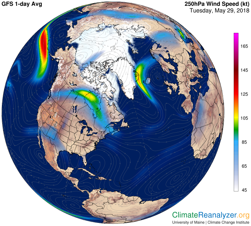
Jet stream winds. Credit: Climate Reanalyzer

Beginning on Saturday, Madison has experienced two straight days in May at or above 90 degrees for the first time since 1991 and for only the third time in nearly the last half-century (the others were in 1975 and 1978).

What’s more, the forecast is for temperatures to soar into the mid-90s again Memorial Day and Tuesday which, if it happens, would be the first time since at least 1971 (and perhaps in its history) that Madison has had four consecutive May days at or above 90.

The underlying causes of this remarkable heat are circumstantial. First, and perhaps most importantly, the jet stream is well north of its normal position for this time of year. Currently located in central Canada, the jet is in a location more common for late July and August. Since the jet is tied to regions of large horizontal temperature contrast, its current position ensures that locations even as far north as Madison are on the warm, tropical side of the hemispheric flow.

In addition, a reasonably strong upper-level trough exists over southern California which has been promoting broad southerly and southwesterly air flow from the Desert Southwest to the High Plains. This has placed a wide expanse of exceptionally warm air just to our west and southwest, ensuring a prolonged period of very warm temperatures over the western Great Lakes states.

So, the warmth we are likely to continue experiencing for the next couple of days is quite unusual for this time of year. Such a warm start to our summer season does not, however, suggest anything at all about the remainder of the summer in terms of warmth. The circumstances of the hemispheric flow patterns that have conspired to create this heat wave may, or may not, conspire again this season.

Steve Ackerman and Jonathan Martin, professors in the UW-Madison Department of Atmospheric and Oceanic Sciences, are guests on WHA radio (970 AM) at 11:45 a.m. the last Monday of each month.
 
Category: Climate, Meteorology, Seasons

Comments Off on Is this hot start to summer unusual?

Will the recent volcanic eruptions in Hawaii lead to a change in global weather patterns?

To impact global weather patterns, a volcano must eject debris into the stratosphere.
(Photo credit: Marco Garcia, Associated Press)

While the recent Hawaiian eruptions are impacting the weather and air quality of the immediate area, they are not likely to have a global impact nor to affect Wisconsin’s weather.

The reason is that the ash cloud debris, while reaching 30,000 feet, has remained in the troposphere, the layer where local weather occurs. To have a global impact, the volcano must eject debris into the stratosphere. There it can last for a couple of years and spread over the entire globe. By the ash reaching only into the troposphere, it can stay airborne for no more than a week due to precipitation processes, wind and gravity.

If volcanic eruptions that reach the stratosphere contain sulfur dioxide gas, they can have an important global impact. The gas can react chemically in the stratosphere to form tiny sulfuric acid droplets. These droplets can reside in the stratosphere for a few years and cause a cooling of global surface temperatures because they reflect solar energy back into space. This was the case with Mount Pinatubo in 1992, which lowered the global temperature about 1 degree over a two-year period.

Volcanic eruptions can lead to cooler temperatures in the mountain’s vicinity because of ash in the atmosphere. The amount of solar energy reaching the surface can be reduced by the ash plume, just like a cloud would do, resulting in a cooler temperature.

Steve Ackerman and Jonathan Martin, professors in the UW-Madison department of atmospheric and oceanic sciences, are guests on WHA radio (970 AM) at 11:45 a.m. the last Monday of each month.
Category: Meteorology, Phenomena

Comments Off on Will the recent volcanic eruptions in Hawaii lead to a change in global weather patterns?

How do I prepare for severe weather?

Severe summer weather can happen at any time and anywhere. The three biggest severe weather killers in the United States today are tornadoes, lightning and flash floods. Your best protection is to be prepared.

Lightning strikes the Wisconsin Capitol reflected on Lake Monona in May 2018.
Photo credit: Kenton Fowler, Monona.

First, you need access to reliable weather information so you remain alert for potential weather hazards. Get a NOAA weather radio for weather updates. Subscribe to wireless emergency alerts, or WEAs, that provide free messages to your cell phone that will alert you about severe weather in your area. For more information on WEA Alerts, go to www.ready.gov/warning-systems-signals.

Tune in to local forecasters on radio or television to get additional information. Local forecasters are experts on regional weather and can interpret observations and conditions for you.

In the case of tornado, go into a tornado shelter or the basement or into a small interior room on the lowest floor of a building, such as a bathroom or closet. Protect yourself from flying debris and stay away from windows. If you are in a mobile home or car, leave it and go to a strong building.

As for lightning, the National Weather Service, or NWS, advocates the simple rule: “When thunder roars, go indoors!” Avoid flagpoles, metal fences, golf carts, baseball dugouts and farm equipment. If you are in a forest, seek shelter in a low area under a thick growth of bushes or small trees.

Move to high ground when threatened by flooding. Stay out of flooded areas. Never drive your car across a flooded road, even if you think the water is shallow. As the NWS says, “Turn around, don’t drown.”

The NWS provides information and ideas for preparing for severe weather and you can learn more safety tips, available at www.ready.gov/severe-weather.

Steve Ackerman and Jonathan Martin, professors in the UW-Madison department of atmospheric and oceanic sciences, are guests on WHA radio (970 AM) at 11:45 a.m. the last Monday of each month.
Category: Meteorology, Severe Weather

Comments Off on How do I prepare for severe weather?

What was the ring around the sun last week?

Halo over Madison, Wisconsin on April 26th.
Photo Credit: Doug Ratcliff, SSEC

Last week there was a ring around the sun for much of the day. This ring is called a halo and is caused by ice crystals interacting with sunlight.

A halo is a whitish ring that encircles but does not touch the sun. It can also have some color; the most discernible is a faint red tint around the inside of the halo. It is an optical phenomenon that owes its existence to the bending of light by ice crystals, much like the “rainbow crystals” you may hang in your sunlit windows.

The most commonly observed halo is the 22-degree halo. This halo encircles the sun at about a hand’s width from the center of the sun, if your arm is fully extended. Small column-like ice crystals form the halo. Light rays enter a crystal, bend or refract, and then refract again as they exit the crystal.

Because the crystals are randomly oriented in space, there are many different directions from which light rays can enter the crystals. Because of the optical properties of ice, more light rays are refracted at a 22-degree angle than at any other, producing the concentration of light known as the halo.

If you were lucky, you may have seen shiny, colored regions at either side of the sun. These are called sundogs, and are another optical effect caused by refraction.

Sundogs appear because ice crystals in the shape of hexagons drift downwards, oriented parallel to the ground. The sunlight passing through the crystal refracts and exits the crystal’s side face and generates the sundog.

Steve Ackerman and Jonathan Martin, professors in the UW-Madison department of atmospheric and oceanic sciences, are guests on WHA radio (970 AM) at 11:45 a.m. the last Monday of each month.
Category: Meteorology, Phenomena

Comments Off on What was the ring around the sun last week?

Has the cold weather this month caused any positive effects?

Rick Fink of Mayville blows snow April 19 in front of his tractor and pulls his planter behind, for fun!
(Photo credit: Ryan Andres, Agri-View)

As a very unusual month of April comes to a close, it may be of interest to note some of its ramifications across the country, both good and bad.

Among the headaches that have resulted from the unrelenting wintry nature of the month was the cancellation of 28 Major League Baseball games through the late part of the month — an all-time record.

To put this number in perspective, 2016 suffered only 25 cancellations through the entire season!

And, of course, a large number of these cancellations were a result of cold and snow.

Other ramifications of the weather this month include a late start for farmers, some of whom are as much as two weeks behind as a consequence of low soil temperatures brought on by the persistent cold.

On the other hand, it may be somewhat comforting to know that the unseasonable coolness of this month has also had a few positive aspects to it.

To this point in the month, not a single tornado has been reported in Oklahoma — the longest the state has ever gone into a year without a tornado.

The dearth of tornadoes is widespread across the Plains as only 229 have been reported across the country so far, about 33 percent fewer than in an average year.

The continued cold through most of the month has been the result of frequent invasions of Arctic air from the north. Such air is relatively dry which has prevented the moist air necessary for the development of severe thunderstorms from pooling over the Plains.

So, as we finally rid ourselves of a notably cold April, it is only fair to remember that it was not all bad.

Steve Ackerman and Jonathan Martin, professors in the UW-Madison department of atmospheric and oceanic sciences, are guests on WHA radio (970 AM) at 11:45 a.m. the last Monday of each month.

Category: Meteorology, Seasons, Severe Weather

Comments Off on Has the cold weather this month caused any positive effects?