Will the recent volcanic eruptions in Hawaii lead to a change in global weather patterns?

To impact global weather patterns, a volcano must eject debris into the stratosphere.
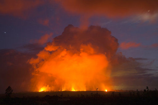
(Photo credit: Marco Garcia, Associated Press)

While the recent Hawaiian eruptions are impacting the weather and air quality of the immediate area, they are not likely to have a global impact nor to affect Wisconsin’s weather.

The reason is that the ash cloud debris, while reaching 30,000 feet, has remained in the troposphere, the layer where local weather occurs. To have a global impact, the volcano must eject debris into the stratosphere. There it can last for a couple of years and spread over the entire globe. By the ash reaching only into the troposphere, it can stay airborne for no more than a week due to precipitation processes, wind and gravity.

If volcanic eruptions that reach the stratosphere contain sulfur dioxide gas, they can have an important global impact. The gas can react chemically in the stratosphere to form tiny sulfuric acid droplets. These droplets can reside in the stratosphere for a few years and cause a cooling of global surface temperatures because they reflect solar energy back into space. This was the case with Mount Pinatubo in 1992, which lowered the global temperature about 1 degree over a two-year period.

Volcanic eruptions can lead to cooler temperatures in the mountain’s vicinity because of ash in the atmosphere. The amount of solar energy reaching the surface can be reduced by the ash plume, just like a cloud would do, resulting in a cooler temperature.

Steve Ackerman and Jonathan Martin, professors in the UW-Madison department of atmospheric and oceanic sciences, are guests on WHA radio (970 AM) at 11:45 a.m. the last Monday of each month.
Category: Meteorology, Phenomena

Comments Off on Will the recent volcanic eruptions in Hawaii lead to a change in global weather patterns?

How do I prepare for severe weather?

Severe summer weather can happen at any time and anywhere. The three biggest severe weather killers in the United States today are tornadoes, lightning and flash floods. Your best protection is to be prepared.

Lightning strikes the Wisconsin Capitol reflected on Lake Monona in May 2018.
Photo credit: Kenton Fowler, Monona.

First, you need access to reliable weather information so you remain alert for potential weather hazards. Get a NOAA weather radio for weather updates. Subscribe to wireless emergency alerts, or WEAs, that provide free messages to your cell phone that will alert you about severe weather in your area. For more information on WEA Alerts, go to www.ready.gov/warning-systems-signals.

Tune in to local forecasters on radio or television to get additional information. Local forecasters are experts on regional weather and can interpret observations and conditions for you.

In the case of tornado, go into a tornado shelter or the basement or into a small interior room on the lowest floor of a building, such as a bathroom or closet. Protect yourself from flying debris and stay away from windows. If you are in a mobile home or car, leave it and go to a strong building.

As for lightning, the National Weather Service, or NWS, advocates the simple rule: “When thunder roars, go indoors!” Avoid flagpoles, metal fences, golf carts, baseball dugouts and farm equipment. If you are in a forest, seek shelter in a low area under a thick growth of bushes or small trees.

Move to high ground when threatened by flooding. Stay out of flooded areas. Never drive your car across a flooded road, even if you think the water is shallow. As the NWS says, “Turn around, don’t drown.”

The NWS provides information and ideas for preparing for severe weather and you can learn more safety tips, available at www.ready.gov/severe-weather.

Steve Ackerman and Jonathan Martin, professors in the UW-Madison department of atmospheric and oceanic sciences, are guests on WHA radio (970 AM) at 11:45 a.m. the last Monday of each month.
Category: Meteorology, Severe Weather

Comments Off on How do I prepare for severe weather?

What was the ring around the sun last week?

Halo over Madison, Wisconsin on April 26th.
Photo Credit: Doug Ratcliff, SSEC

Last week there was a ring around the sun for much of the day. This ring is called a halo and is caused by ice crystals interacting with sunlight.

A halo is a whitish ring that encircles but does not touch the sun. It can also have some color; the most discernible is a faint red tint around the inside of the halo. It is an optical phenomenon that owes its existence to the bending of light by ice crystals, much like the “rainbow crystals” you may hang in your sunlit windows.

The most commonly observed halo is the 22-degree halo. This halo encircles the sun at about a hand’s width from the center of the sun, if your arm is fully extended. Small column-like ice crystals form the halo. Light rays enter a crystal, bend or refract, and then refract again as they exit the crystal.

Because the crystals are randomly oriented in space, there are many different directions from which light rays can enter the crystals. Because of the optical properties of ice, more light rays are refracted at a 22-degree angle than at any other, producing the concentration of light known as the halo.

If you were lucky, you may have seen shiny, colored regions at either side of the sun. These are called sundogs, and are another optical effect caused by refraction.

Sundogs appear because ice crystals in the shape of hexagons drift downwards, oriented parallel to the ground. The sunlight passing through the crystal refracts and exits the crystal’s side face and generates the sundog.

Steve Ackerman and Jonathan Martin, professors in the UW-Madison department of atmospheric and oceanic sciences, are guests on WHA radio (970 AM) at 11:45 a.m. the last Monday of each month.
Category: Meteorology, Phenomena

Comments Off on What was the ring around the sun last week?

Has the cold weather this month caused any positive effects?

Rick Fink of Mayville blows snow April 19 in front of his tractor and pulls his planter behind, for fun!
(Photo credit: Ryan Andres, Agri-View)

As a very unusual month of April comes to a close, it may be of interest to note some of its ramifications across the country, both good and bad.

Among the headaches that have resulted from the unrelenting wintry nature of the month was the cancellation of 28 Major League Baseball games through the late part of the month — an all-time record.

To put this number in perspective, 2016 suffered only 25 cancellations through the entire season!

And, of course, a large number of these cancellations were a result of cold and snow.

Other ramifications of the weather this month include a late start for farmers, some of whom are as much as two weeks behind as a consequence of low soil temperatures brought on by the persistent cold.

On the other hand, it may be somewhat comforting to know that the unseasonable coolness of this month has also had a few positive aspects to it.

To this point in the month, not a single tornado has been reported in Oklahoma — the longest the state has ever gone into a year without a tornado.

The dearth of tornadoes is widespread across the Plains as only 229 have been reported across the country so far, about 33 percent fewer than in an average year.

The continued cold through most of the month has been the result of frequent invasions of Arctic air from the north. Such air is relatively dry which has prevented the moist air necessary for the development of severe thunderstorms from pooling over the Plains.

So, as we finally rid ourselves of a notably cold April, it is only fair to remember that it was not all bad.

Steve Ackerman and Jonathan Martin, professors in the UW-Madison department of atmospheric and oceanic sciences, are guests on WHA radio (970 AM) at 11:45 a.m. the last Monday of each month.

Category: Meteorology, Seasons, Severe Weather

Comments Off on Has the cold weather this month caused any positive effects?

Has this April set any records?


A large snow sculpture graces State Street Mall on Thursday, the day after Madison saw 7.2 inches of snow, more than doubling the previous daily record for snowfall (3.4 inches in 1912) on April 18. (Photo credit: Steve Apps, State Journal)

A fitting climax to a remarkable first two-thirds of April occurred last Wednesday as we received 7.2 inches of snow in Madison, more than doubling the previous daily record for snowfall (3.4 inches in 1912) on April 18.

There have only been two years with heavier snow events later than Wednesday’s. The most was 7.8 inches on April 30, 1994, and the second was a 7.3-inch event on April 23, 1910.

Though there are too many remarkable aspects of this event to detail here, mention of a few of them is certainly warranted. First of all, the first two-thirds of the month have left us 12.8 degrees below normal for the month — the coldest first 20 days of April ever in Madison.

Second, Wednesday’s heavy snow was forecast well in advance. In fact, as the nearly 2 inches that fell on April 15 was winding down, most people in the area knew that a more substantial snow was on the way for Wednesday. Dawn on Wednesday was crystal clear, the kind of morning that a couple of decades ago would have immediately inspired hopes that the forecast for the coming snow would be in error. That is simply not usually the case in the current era.

Even disturbances of relatively small scale like the one that dropped the snow on Wednesday are quite often very accurately forecast by the present generation of sophisticated computer prediction models. The snow started around 11 a.m. and ended in the early evening, nearly precisely as forecast.

Third, the following two days with their bright, late April sunshine provided us with an additional rare spectacle — rapid melting of a deep snow layer. By the end of the day Thursday, a good deal of snow had disappeared in the face of the sunshine. By Friday night, only shady spots still had any trace of the record snow that had fallen just two days before.

And we had a chance today to tie the all-time record for latest calendar day on which 60 degrees is first reached, set in 1904 on April 23. Through Saturday, we had not seen 60 degrees since Dec. 4, with Monday’s forecast calling for a high of 62. But on Sunday it hit 62.

Category: Meteorology, Seasons

Comments Off on Has this April set any records?