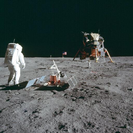
What is the Beaufort scale?

Wave watchers check out the ocean action near Peggy’s Cove, Nova Scotia, during Hurricane Bill in August 2009. Based on observations rather than measurements, the Beaufort scale is a method of estimating wind speed based on the general condition of the surface of a large body of water with respect to wind waves and swell. (Photo credit: Associated Press Archives)

The Beaufort scale is a method of estimating wind speed based on the general condition of the surface of a large body of water with respect to wind waves and swell.

It is based on observation of sea state rather than accurate wind measurements. This scale allows sailors to estimate the wind speed just by observing the state of the sea surface.

The scale has a long history, but was finalized in 1805 by Rear Admiral Sir Francis Beaufort, an Irish hydrographer in the British Royal Navy. It was officially first used during the voyage of Charles Darwin on the HMS Beagle (1832-1835).

The Beaufort scale can also be applied to conditions on land, but it is most often associated with the sea state.

The modern-day Beaufort scale consists of 13 numbers ranging from 0 to 12. A zero value on the Beaufort scale is assigned to calm winds and the water surface is smooth.

A Beaufort force 12 occurs with waves greater in height than 46 feet and the sea is completely white with foam and spray with greatly reduced visibility. Such conditions are associated with wind speeds of greater than 74 mph, which are hurricane-force winds.

The National Weather Service defines sustained wind speeds of 39 to 54 mph as a gale, and forecasters typically issue gale warnings when winds of this strength are forecast. A Beaufort force 6 is a near gale with wind speeds between 25 and 30 mph and includes white foam from breaking waves that begins to be blown in streaks along the wind direction.

A Beaufort force in the range of 6 to 7 is designated as strong winds; 8 to 9 as gale-force winds; and 10 to 11 as storm-force winds.

Category: Meteorology, Severe Weather

Comments Off on What is the Beaufort scale?

When did computer-based weather forecasts begin?

NOAA historic weather computer circa 1965, used to process weather data for short and long-range forecasts, analyses, and research. (Photo credit: NOAA’s National Weather Service Collection)

Just over a week past our extraordinary late season snow on April 27, it is worth considering how remarkable it is that such an unusual event can be so well forecasted several days in advance.

The drive to use computer models for weather forecasting had its origins in the immediate aftermath of World War II, initiated at a secret meeting at U.S. Weather Bureau headquarters on the rainy morning of Jan. 6, 1946.

After a series of successes and setbacks that mostly discouraged the broad meteorological community, the first operational computer-generated forecasts were issued on the afternoon of May 6, 1955. Thus, in less than 10 years the notion of a computer-based forecast went from dream to reality.

In the intervening 64 years, the combination of increased theoretical understanding both of meteorology and computational science, increased observational capacity — a good deal of which stems from satellite data — and sheer hard work on the part of a legion of dedicated scientists has resulted in our current forecasting capability.

The fact that our ubiquitous smartphones give everyone access to quite reasonable forecasts several days in advance is the end result of what might be considered the greatest scientific advance of the second half of the 20th century.

It is likely that had our late season snow come in April 1947, or even 1977, we would have been caught unpleasantly by surprise. Luckily, thanks to longstanding commitments to investment in basic scientific research, we are in a much better position today.

So, as you consult your phone for the forecast, remember that the first baby steps in numerical weather prediction were taken 64 years ago this May.

Steve Ackerman and Jonathan Martin, professors in the UW-Madison Department of Atmospheric and Oceanic Sciences, are guests on WHA radio (970 AM) at 11:45 a.m. the last Monday of each month.
Category: Uncategorized

Comments Off on When did computer-based weather forecasts begin?

What is a cyclone?

Hurricane Michael in the Gulf of Mexico in October 2018. NOAA recently upgraded Michael from a Category 4 storm to a Category 5, making Michael only the fourth tropical cyclone on record to hit the U.S. as a Category 5 hurricane. (Image credit: NOAA)

A cyclone is a general term for a weather system in which winds rotate inwardly to an area of low atmospheric pressure.

For large weather systems, the circulation pattern is in a counterclockwise direction in the Northern Hemisphere and a clockwise direction in the Southern Hemisphere.

Types of cyclones include tropical cyclones, extratropical cyclones and tornadoes.

A tropical cyclone is a rotating low-pressure weather system that has organized thunderstorms but no fronts. They form over warm ocean waters.

Tropical cyclones with maximum sustained surface winds of less than 39 mph are called tropical depressions. Those with maximum sustained winds of 39 mph or higher are called tropical storms. When a storm’s maximum sustained winds reach 74 mph they are called hurricanes or typhoons. Hurricanes form over the Atlantic Ocean or Caribbean Sea; typhoons form over the western Pacific Ocean.

Extratropical cyclones are low-pressure systems that form outside of the tropics in response to a chronic instability of the westerly winds. Because this instability is dependent on large horizontal temperature contrasts, concentrated regions of temperature change known as fronts characterize extratropical cyclones.

These storms populate the middle and high latitudes, north of 35 degrees latitude in the Northern Hemisphere, and thus they also are called “mid-latitude cyclones.” If the barometric pressure of a mid-latitude cyclone falls by at least 1 millibar per hour for 24 hours, the storm is referred to as a “bomb cyclone.”

A tornado is a rapidly rotating column of air extending downward from a thunderstorm to the ground. The most violent tornadoes are capable of tremendous destruction with wind speeds of up to 300 mph.

Tornadoes form in regions of the atmosphere that have abundant warm and moist air near the surface with drier air above, and a change in wind speed and wind direction with height above the ground.

Category: Meteorology, Severe Weather

Comments Off on What is a cyclone?

Why was there a reddish tint in the snow this month?

Satellite image of the strong winds carrying dust from the southwestern deserts getting caught up into the April snowstorm that hit the upper Midwest. (Photo credit: CIMSS)

On April 10, there were strong winds associated with an intensifying mid-latitude cyclone over Arizona and western Texas. Winds were gusting as high as 77 mph in New Mexico and 88 mph in Texas.

The winds associated with this storm generated large plumes of blowing dust in southeastern Arizona, southern New Mexico, northern Mexico and western Texas. Willcox Playa, a dry lake in southeastern Arizona, was the source of some of the dust ranging in shades of tan to light brown.

Satellite observations tracked the movement of this dust, or aerosol, northeastward across the Upper Midwest. As the wind weakened, it deposited the dust on the ground, often on recently fallen snow, where it left a reddish tint.

Dust can be transported across the globe. Micrometer-size soil particles from deserts can be lifted by the wind to high altitudes and transported over thousands of miles. Desert dust from the Sahara and Gobi deserts has been observed on the ice sheet of Greenland.

Ice cores in Greenland provide a history of the dust deposition as they appear as layers in the ice. The mineralogy of the dust in the ice allows scientists to trace the desert of origin. The source also allows scientists to determine global wind patterns from thousands of years ago, as atmospheric circulation patterns that carry Saharan dust will be different than the global circulations that can transport dust from Asia to Greenland.

Category: Meteorology, Severe Weather

Comments Off on Why was there a reddish tint in the snow this month?

Is there a windiest time of year in Madison?

Matt Erdmann, of Madison, takes advantage of a winter wind as he kiteboards at Olbrich Park along the shore of Lake Monona. The climatology suggests that March and April are the windiest months, with average wind speeds of 11.3 and 11.4 mph, respectively, but November through February are not far behind, logging a four-month average of 10.5 mph. (Photo credit: Amber Arnold, State Journal Archives)

Given our recent weather, and with the pollen season dawning in southern Wisconsin, one may wonder if there actually is a windiest time of year in Madison.

Of course, a windy day can come along just about any time of year (the record gust of 83 mph in Madison occurred in June 1975) but the climatology suggests that March and April are the windiest months of the year with average wind speeds of 11.3 and 11.4 mph, respectively. November through February are not far behind, logging a four-month average of 10.5 mph.

The fact that it’s windier during the cold season is not surprising as that time of year is characterized by the highest frequency of mid-latitude cyclone activity. Mid-latitude cyclones are large in scale, covering several states simultaneously, and are often associated with very large differences in sea-level pressure over small distances. It is these pressure differences that drive the wind.

The particular maximum in March and April may reflect the fact that late winter and early spring storms have a higher chance of containing thunderstorms that can locally enhance the winds. It may also be that on a sunny March or April day the daytime heating contributes to a slightly breezier day than might be observed on a similarly sunny day in the depth of winter.

With regard to the pollen issue, it is interesting that the windiest month (April) occurs when plants are most in need of assistance in spreading pollen and reproducing. The power of evolution!

Category: Climate, Seasons, Weather Dangers

Comments Off on Is there a windiest time of year in Madison?