How did this winter compare to average?

Less than two weeks ago, on Feb. 17, Madison reached its annual climatological amount of snowfall — 51 inches — with a 5.2-inch fall. This is yet another wrinkle in what has been a very unusual winter.

Almost everyone remembers the early snowfalls of late October and early November that delivered a total of 16 inches of seasonal snowfall by Nov. 11. Perhaps forgotten, however, is the seven-week snow drought that followed, with the next 1-inch snowfall — 1.5 inches to be exact — finally arriving on Dec. 30.

An unusually snowy period followed, beginning on Jan. 10. From that day until the end of February, 35 inches of snow fell — nearly a foot more than the normal 24 inches for that interval each winter.

The Jekyll and Hyde nature of this past winter is also reflected in the temperatures that started out 5.2 degrees below average in November and then soared to 7.0 and 7.3 degrees above normal for December and January, respectively. The recently completed February was almost exactly normal.

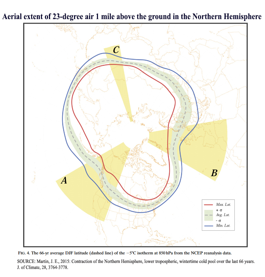
Hemispherically, the areal extent of the 23-degree air about 1 mile above the ground registered its third-lowest value seasonal average in the 72-year record. So, the relatively mild winter we experienced here in Madison was enjoyed by a large number of other locations around the Northern Hemisphere this year.

Looking forward, March averages 8 inches of snowfall, while the daily high temperatures rise from an average of about 38 degrees at the start of the month to near or just above 50 degrees by its end. While there is no guarantee that March will treat us equally kindly, even if we have a cold March it will have been a relatively easy winter when it finally does end.

Steve Ackerman and Jonathan Martin, professors in the UW-Madison department of atmospheric and oceanic sciences, are guests on WHA radio (970 AM) at 11:45 a.m. the last Monday of each month. Send them your questions at stevea@ssec.wisc.edu or jemarti1@wisc.edu.

Category: Climate, Seasons

Comments Off on How did this winter compare to average?

What’s up with the Antarctic weather?

New NASA satellite images reveal the dramatic effects of February’s record-breaking heatwave on Eagle Island in Antarctica.  (Photo credit: NASA Earth Observatory)+

On Feb. 6, a record high temperature of 65 degrees was recorded at a research base located at the most northern tip of Antarctica. That beats the previous record of 63.5 set in March 2015.

Then on Feb. 9, the temperature on Seymour Island in the Antarctic Peninsula reached 69.5, setting a new record. This is the warmest temperature measured on the world’s coldest continent.

The weather stations that recorded these temperatures are located in the area of Antarctica that is closest to South America. The interior of the continent does not approach these temperatures, being some of the coldest places on Earth.

The record temperatures may not be a direct cause of global or regional warming. The record may be associated with a foehn, a warm and dry wind that develops in the lee of any mountain range. As air descends a mountain it is compressed, which causes the temperature to rise and the relatively humidity to lower.

The region is experiencing episodes of stronger warm winds, which helps to melt the ice sheets. The Antarctic Peninsula is one of the fastest-warming regions of the globe. Many of the glaciers in that region are retreating rapidly.

Antarctica contains around 90 percent of all of the ice on Earth. Global climate change is warming the Antarctic. Ice on the coldest regions are now melting and adding fresh water into the surrounding ocean.

The loss of ice on the continent has been accelerating since the late 1960s. About 25% of the observed global sea-level rise is estimated to result from the melting of the Antarctica ice. If all the ice melted, which is perhaps unlikely, sea level would rise about 200 feet.

Category: Climate, Seasons

Comments Off on What’s up with the Antarctic weather?

What is snow sparkle?

The sun shines through the trees in the UW-Arboretum. Light reflecting off ice crystals that have settled on the top of snow can produce snow sparkle. (Photo credit: Michelle Stocker, Capital Times archives)

Saturday was a bright, sunny day, and if you were walking by an undisturbed field of snow, the snow may have appeared to sparkle.

Snow sparkle is caused by light reflecting off ice crystals that have settled on the top of the snow.

When light hits an object three things happen. The light can be reflected, in which case it bounces off in a new direction; it can be absorbed, in which case the object is heated; and it can be transmitted, in which case light passes through the object. The law of reflection states that when light is reflected from a smooth surface, the angle of reflection is equal to the angle of incidence and the two rays lie in the same plane.

Snow is made of ice crystals, and as a crystal gently falls on a surface, it may lie relatively flat. Some crystals are smooth and can act like mirrors and reflect light. When conditions are right, rays of light hit individual ice crystals that are on the uppermost layer of snow and reflect the light upward, at the angle of reflection. The reflected light will be bright, a small image of the sun.

For the light ray to hit your eye and become visible, the crystal has to be lying at the correct angle on the surface so the angle of reflection sends the beam your way. Of the thousands of ice crystals lying on the surface, you see only those that align correctly. If you move, you encounter different crystals that also are at the correct orientation.

Dry conditions can increase the likelihood of seeing snow sparkles because ice crystals often stay separate in drier conditions. Warmer days decrease the likelihood of seeing snow sparkles because, as the crystals may melt, they merge together and may not lie as a flat reflective surface.

Category: Phenomena, Seasons

Comments Off on What is snow sparkle?

What is geoengineering?

Geoengineering literally means “Earth-engineering.” It is a term that describes how people could intervene in Earth’s functions to slow down or reverse the effects of climate change.

Current discussions of geoengineering focus on two broad categories to reduce global warming.

The first general idea is to cool the planet by reducing the amount of solar energy it absorbs. This could be done by increasing the amount of solar energy reflected back to space.

One approach is to build space reflectors, which would block a small portion of sunlight by reflecting the energy away from Earth.

Some geoengineering ideas replicate effects of volcanic eruptions, which often cause cooling because ash and aerosols reflect solar energy back into space.
(Photo credit: Pixabay)

Another proposed technique is to inject aerosols into the stratosphere. This approach attempts to replicate the effect of explosive volcanic eruptions, such as Mount Pinatubo in 1991. That eruption spewed tiny aerosols into the stratosphere that scattered sunlight back into space, which over the next 15 months decreased the average global temperature by about 1 degree.

The second category of ideas seeks to remove carbon dioxide from the atmosphere and thus reduce its accumulation in Earth’s atmosphere. Carbon geoengineering proposals posit that carbon can be removed from the atmosphere on a massive, global scale using a combination of biological and mechanical methods. Global-scale tree planting is one example. Another is to build large machines that directly remove atmospheric carbon dioxide and store it elsewhere.

Geoengineering comes with risks and significant uncertainties. Intervening in a complex system can give unexpected results. While there may be global benefits, local impacts could vary widely and may not benefit the region. For example, shifts in precipitation patterns leading to local droughts. There is also the question of economic cost as some of the proposed techniques are costly.

Steve Ackerman and Jonathan Martin, professors in the UW-Madison department of atmospheric and oceanic sciences, are guests on WHA radio (970 AM) at 11:45 a.m. the last Monday of each month.

Category: Climate

Comments Off on What is geoengineering?

Is water everywhere?

Water Vapor (right) and True Color (left) satellite images revealing water on Earth.

Evidence of the presence of water in our atmosphere is ubiquitous.

Water occurs in the Earth’s atmosphere in all three of its phases — solid (snow and ice), liquid (rain and dew) and gas (invisible water vapor).

In the next weeks, as we begin to emerge from winter and enter spring, we may begin to see more dew on the ground and on the windshields of cars in the morning. The air nearly always holds some amount of water vapor. Dew is liquid water that condenses overnight onto objects when the air that contains the water vapor cools to a sufficiently low temperature.

One of the important and microscopic characteristics of the condensation process is that water vapor will not condense into liquid water very easily unless it condenses onto a foreign object, such as the tiny hairlike structures on grasses or dust and pollen particles on windshields. In fact, on particularly dewy mornings, if you wait for the dew to evaporate you may find yellow stains on your windshield that are left as the liquid water evaporates leaving the pollen particles on which it originally condensed.

The formation of raindrops requires a similar collection of foreign objects upon which water vapor can condense. Such objects are known as cloud condensation nuclei, and a great number of naturally occurring substances can serve this role, including dust particles, smoke particles, salt particles, pollen grains, particulate matter from smokestacks and naturally occurring aerosol particles.

Without these cloud condensation nuclei, the formation of cloud liquid water droplets, and eventually precipitation-size particles — which are 1 million times more voluminous — would be considerably more difficult in our atmosphere. In that case, rain and snow would be rare occurrences, and life on the planet would be put at risk.

Steve Ackerman and Jonathan Martin, professors in the UW-Madison department of atmospheric and oceanic sciences, are guests on WHA radio (970 AM) at 11:45 a.m. the last Monday of each month.

Category: Climate, Meteorology

Comments Off on Is water everywhere?