Why does the severe weather threat increase as spring and summer approach?

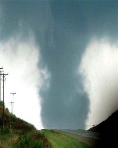
A tornado that struck Stoughton on August 18, 2005, is seen southwest of Highway 51 as it approached the city. (Photo credit: Dale Bernstein, NOAA/NWS)

As the threat of winter snows recedes across the country, it is replaced by the threat of severe weather — thunderstorms with hail, damaging winds and tornadoes.

The severe weather season, though broadly spanning March through August across the United States, is actually quite regional. It begins in March in the southern states, moves to the southern Plains during April and May, and then farther north toward the Great Lakes states during the summer.

One of the basic underlying reasons for this northward migration of the severe weather threat during the spring and summer is the fact that the jet stream follows a similar seasonal cycle. The jet stream is a ribbon of high wind speeds located near the top of the troposphere, about 6 miles above the surface of the Earth.

The jet stream position is strongly tied to the southern edge of the dome of cold air that is centered on the North Pole. During the depths of winter, that cold dome expands considerably, extending nearly to the Gulf of Mexico. As the winter ends and spring approaches, the hemisphere begins to warm up and the cold dome shrinks dramatically. Its southern edge moves to central Canada by early summer.

The jet stream is associated with vigorous vertical circulations, or upward and downward motions. The upward vertical motions are instrumental in producing thunderstorms. Thus, when the jet stream migrates northward as the weather warms in spring and summer, so does the greatest concentration of severe weather outbreaks. This very sort of situation characterized the severe outbreak over the weekend in northern Illinois.

Category: Meteorology, Seasons, Severe Weather

Comments Off on Why does the severe weather threat increase as spring and summer approach?

Did spring come early this year?

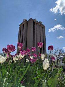
Tulips outside the UW Atmospheric, Oceanic and Space Science building spring 2019.

Astronomically, spring occurs when the sun’s rays strike the equator at noon at an angle that is directly overhead.

This particular time varies from year to year due to variations in Earth’s orbit about the sun. In the Northern Hemisphere, the vernal, or spring, equinox (“equi” meaning “equal,” and “nox,” “night”) occurs sometime between March 19 and 23, but often on March 20 or 21.

This year, Northern Hemisphere spring arrived at around 10:49 p.m. Thursday. This was the first day of autumn in the Southern Hemisphere. The last time the vernal equinox occurred this early was in 1896.

During the equinoxes, all locations on Earth experience 12 hours of daylight and 12 hours of darkness. The sun rises due East and sets due West. The seasons result from the tilt of our planet and its yearly circling of the sun.

Spring marks the transition from winter to summer so meteorologists define March through May as the three months of spring. By that definition, spring already started.

We might also define spring as the day on which, if there is precipitation, it is more likely to be in the form of rain than snow. For southern Wisconsin, that occurs later in the month of March.

We also may define spring based on the appearance of a particular flower, the blooming of certain trees, or the return of specific migrating birds. These are the phenological signs of spring.

Some mark spring by the increase in the number of potholes.

Whatever the definition, during spring the length of daylight hours is increasing and the air is warming. That’s welcome news for many people, particularly this year when many are staying home to avoid COVID-19.

Steve Ackerman and Jonathan Martin, professors in the UW-Madison department of Atmospheric and Oceanic Sciences, are guests on WHA radio (970 AM) at 11:45 a.m. the last Monday of each month.

Category: Climate, Meteorology, Seasons

Comments Off on Did spring come early this year?

Will spring temperatures affect the COVID-19 outbreak?

The COVID-19 outbreak continues to expand across the U.S. and globally. What happens when spring and warmer weather arrives?

Some viral respiratory diseases, such as influenza, are seasonal, and cases decrease in the spring and summer. However, we do not know what to expect from the new coronavirus that causes COVID-19.

Lab studies have shown that the quantity of water vapor in the air strongly affects the transmission of influenza, with drier conditions being more favorable. By “drier” we mean lower absolute humidity, which is a measure of the quantity of water molecules in the air. The air is drier in winter both indoors and out. In general, in temperate countries like the U.S., dry cold air is a favorable condition for flu transmission.

Lab studies have investigated only the transmission of the flu so far. We do not know of specific studies for the role of humidity in regard to coronaviruses. Thus, for coronaviruses, the relevance of humidity is unknown.

New viruses may lack a seasonal dependence for infection. As few individuals in the population are immune, a new virus may not require the most favorable conditions to spread. So, we cannot assume that the new coronavirus SARS-CoV-2, the virus that causes COVID-19, will go away on its own when the warmer weather arrives. Also, we lack the data on other weather factors on the coronavirus, such exposure to ultraviolet radiation from the sun.

At this point, we don’t know enough about this virus to understand how the changing weather patterns will impact its behavior. The best approach is to continue healthy practices and follow health officials’ guidance on how to avoid contamination.

Steve Ackerman and Jonathan Martin, professors in the UW-Madison department of Atmospheric and Oceanic Sciences, are guests on WHA radio (970 AM) at 11:45 a.m. the last Monday of each month.

Category: Meteorology, Phenomena, Weather Dangers

Comments Off on Will spring temperatures affect the COVID-19 outbreak?

How severe was our just-completed meteorological winter?

Employing data from the last 72 winter seasons — December, January and February — we have been examining the size of the area one mile above sea level over the Northern Hemisphere that was colder than 23 degrees.

After recording the warmest December ever, since the cold area was the smallest found using this methodology, this year’s winter season ended up as the fifth-warmest of the last 72 — fairly impressive. In fact, perhaps not surprisingly, 14 of the 20 warmest winters by this measure have occurred since 2001-02, with the warmest being 2014-15.

Using similar data, but including March as well, we have recently been attempting to develop a reasonable measure of the duration of winter over the Great Lakes region. We divided the 72-year data set into two 30-year periods, 1948-49 to 1977-78 and 1980-81 to 2009-10. We then determined, for each 30-year period, the calendar days on which there was, on average, a 90% or 10% chance that the coldest day of the year was still yet to come.

For instance, no winter in the record has recorded its coldest day as early as Dec. 1. Thus, on that day, the chance that a colder day is still to come is 100%. Conversely, no winter has ever had its coldest day as late as March 31. That calendar day therefore has a 0% chance that a colder day is still coming.

In the older data set, the 90% day is Dec. 16, while the 10% day is March 3. Thus, one could make an argument that, on average, our winter extended from Dec. 16 to March 3 in that period. In the more recent data set, the 90% to 10% interval extends from Dec. 30 to Feb. 18 — nearly four weeks shorter than the prior period.

Thus, as the Earth continues to warm, not only is winter less extreme, but it may also be substantially shorter.

Category: Climate, Seasons

Comments Off on How severe was our just-completed meteorological winter?

Wisconsin ‘Weather Guy’ and longtime prof to lead UW-Madison research enterprise

Weather Guy Steve Ackerman, the new Vice Chancellor for Research and Graduate Education.
Weather Guy Steve Ackerman, the new Vice Chancellor for Research and Graduate Education at the UW-Madison.

A longtime university professor will oversee UW-Madison’s research enterprise and graduate education, the university announced Monday.

Chancellor Rebecca Blank named Steve Ackerman the next vice chancellor for research and graduate education, one of a handful of high-profile positions that report directly to Blank. The job entails overseeing $1.2 billion in annual research spending and thousands of graduate students.

Ackerman emerged as the top choice in a search that began in 2018 but was put on hold last spring. He faces the challenge of reversing a recent slide in the university’s national research ranking and increasing research conducted in collaboration with businesses, an area in which UW-Madison significantly lags behind peer institutions.

He has served in the position on an interim basis since August and will assume full responsibilities next week. During a Faculty Senate meeting Monday, he said he is confident UW-Madison will increase its research spending level in the next round of rankings.

“As UW-Madison looks to maintain and strengthen its role as a research powerhouse and build important partnerships across campus and beyond, Steve is the most thoughtful and innovative leader for the job,” Blank said in a statement.

Ackerman came to UW-Madison in 1987 and in 1992 became a professor in the Department of Atmospheric and Oceanic Sciences, where his research focused on the energy balance of the Earth’s atmosphere.

He has served in a number of leadership positions, including associate vice chancellor of research in the physical sciences, interim director of the Space Science and Engineering Center, and director of NOAA’s Cooperative Institute for Meteorological Satellite Studies (CIMSS) for 18 years. He has also co-written a popular weekly column in the State Journal, “Ask the Weather Guys,” for many years. A university spokeswoman said he plans to continue it in his new role.

Ackerman has mentored more than 60 master’s and doctoral students — work he said he will miss the most in his new role.

Among Ackerman’s priorities in his new post are to create a campuswide mentoring program and improve the efficiency of the university’s boards that review research involving human research subjects.

This content was featured in the Wisconsin State Journal on March 3, 2020.

Category: Uncategorized

Comments Off on Wisconsin ‘Weather Guy’ and longtime prof to lead UW-Madison research enterprise