Has March been a bit unusual so far?

It has been a fairly benign first two weeks of March for those of us in southern Wisconsin.

2021 Daily Temperatures for Madison through March 12th. Note the large swing from February to March denoted by the black line. Credit: Wisconsin Climatology Office

Through the first 11 days of the month, we have averaged 6.2 degrees above normal. In fact, in the nearly three weeks since Feb. 22 — when we had this season’s maximum snow depth of 16 inches in Madison — we have averaged the same 6.2 degrees above normal.

During that stretch of days, we have had only three (March 1, 2 and 4) where the daily average temperature was below normal — and it was only slightly below at that. The result of this exceptional, uninterrupted stretch of mild weather has been the most rapid disappearance of a substantial snow cover that we have seen in quite some time in Madison.

Officially, March 10 was the first day with a snow depth of zero inches since Dec. 11. During this late-winter mild spell we have lost nearly 1 inch of snow cover each day for nearly three weeks.

It is important to remember that March is not always so kind. In fact, traditionally the week of March 10-17 has been quite wintery on occasion across the country. In 1870, the word “blizzard” was first used to describe a snowstorm in Iowa’s Estherville Indicator (March 14). New York City was visited by its worst snowstorm ever on March 12-13, 1888. The worst blizzard in the history of Minnesota and North Dakota occurred on March 15, 1941; 4 feet of snow fell at Inwood, Iowa, on March 11, 1962, and the “Storm of the Century” dropped snow from Alabama to Maine on March 13, 1993.

So, if you have been conscious of a certain benevolence to this March’s weather thus far, your instinct is correct.

Steve Ackerman and Jonathan Martin, professors in the UW-Madison Department of Atmospheric and Oceanic sciences, are guests on WHA radio (970 AM) at 11:45 a.m. the last Monday of each month.

Category: Climate, Meteorology, Seasons

Comments Off on Has March been a bit unusual so far?

What is special about March weather?

Leah Salsano, right, and her sister, Kira, of Poynette, check the buckets attached to maple trees that are tapped for sap at the MacKenzie Center. In Wisconsin, March is a prime month for tapping sugar maple trees, and this is when the sap is sweetest. (Photo credit:  Amber Arnold, State Journal)
Leah Salsano, right, and her sister, Kira, of Poynette, check the buckets attached to maple trees that are tapped for sap at the MacKenzie Center. In Wisconsin, March is a prime month for tapping sugar maple trees, and this is when the sap is sweetest. (Photo credit: Amber Arnold, State Journal)

March 1 marks the beginning of spring and kicks off an active and variable weather season. Flooding, temperature swings, tornados and snowstorms are all common springtime weather events.

A flood occurs when water flows into a region faster than it can be absorbed into the soil, stored in a lake or reservoir, or removed in runoff or a waterway into a drainage basin. In early spring, the ground can still be frozen and so cannot absorb the precipitation. Rain and melting snow will instead flow into rivers causing springtime flooding.

As the sun rises higher in the sky and the day’s length gets longer, our temperatures warm. March is the month with the greatest difference between the all-time warmest and coldest days. In March, we often have nighttime temperatures below freezing and daytime temperatures above freezing due to the longer daylight hours. This temperature cycle results in freeze-thaw cycles.

This cycling can cause potholes, as surface water seeps below the surface during the warm days and then freezes at night. The nighttime expansion of the freezing water can cause cracks in the roadway.

This alternate freezing and thawing temperature cycle also causes pressure changes inside trees, resulting in sap flow. Tapping maple trees usually occurs in late winter and early spring. In Wisconsin, March is a prime month for tapping sugar maple trees and this is when the sap is sweetest.

Tornadoes are very destructive events. While tornadoes can occur at any time of the year, tornado outbreaks are probably the weather event most often associated with spring. Tornado activity in the lower 48 states begins to increase in March before peaking in April, May and June.

Snowstorms are not uncommon in March. Their often heavy snowfall can bring down trees and powerlines.

Steve Ackerman and Jonathan Martin, professors in the UW-Madison department of atmospheric and oceanic sciences, are guests on WHA radio (970 AM) at 11:45 a.m. the last Monday of each month. Send them your questions at stevea@ssec.wisc.edu or jemarti1@wisc.edu.
Category: Climate, Seasons

Comments Off on What is special about March weather?

How severe was the Northern Hemisphere winter this year?

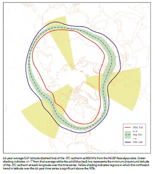
Warming in the Northern Hemisphere determined by a shrinking cold pool aloft measured by the National Center for Environmental Prediction (NCEP) reanalysis data. Credit: J. Martin

Today is March 1 so the meteorological winter (December-January-February) is over.

The areal extent of air colder than minus 23 degrees at about 1 mile above the ground throughout December through February is one way of comparing the severity of the Northern Hemisphere winter from one year to the next.

Using the National Center for Environmental Prediction (NCEP) reanalysis data set we have been able to make such a calculation for each winter season since 1948-49. Despite the severe cold snap experienced over much of North America in the middle of February this year, the seasonal average cold pool area over the entire hemisphere was the ninth smallest in the last 73 years. This is consistent with a systematic shrinking of the wintertime cold pool extent that has seen the average seasonal area decrease by nearly 5% since 1948.

This shrinkage is, of course, at the southern edge of the cold pool and is not a function of changes in weather systems that parade around the globe on that edge. Instead, it is a result of increased retention of infrared radiation emitted by the surface of the Earth which is intercepted primarily by the increased concentration of carbon dioxide in the atmosphere.

The monthly average carbon dioxide concentration in the atmosphere for January 2021, the last month for which averaged values were available, was 415.52 parts per million (ppm). That compares to 354.93 ppm just 30 years ago and 316.89 ppm 60 years ago. This means that the rate of increase has more than doubled in the past 30 years.

The shrinking of the wintertime cold pool is a predictable result of this increase — an increase that lies behind the unmistakable global warming that continues to alter the climate.

Steve Ackerman and Jonathan Martin, professors in the UW-Madison department of atmospheric and oceanic sciences, are guests on WHA radio (970 AM) at 11:45 a.m. the last Monday of each month

Category: Climate, Meteorology, Seasons

Comments Off on How severe was the Northern Hemisphere winter this year?

When does the last deep cold spell of the winter usually come?

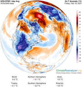
Temperature anomalies outline the extreme cold air outbreak of winter 2021. (Image credit: Climate Reanalyzer, Climate Change Institute, University of Maine)

As we all work to recover from our recent cold spell, the natural question is: Are we done with bitter cold for the winter?

If we use an overnight low temperature at or below zero as the definition of a cold spell, then 41 of the 81 winters since 1939-40 have seen a cold spell after Feb. 22 — that’s 50.6% of the time. In fact, in 1982 the last zero-degree or colder night was not until April 2, the latest date in the last 81 years.

None of this bodes well for our chances this year. It should be noted, however, that in the last 20 years, the latest cold spell occurred March 10, in 2003.

Recent research at UW-Madison has documented a systematic warming of the lower troposphere during Northern Hemisphere winter over the past 71 seasons. Elements of that analysis have suggested that the hemisphere begins its warm up much earlier than the spring equinox, which occurs around March 22. In fact, the hemispheric warm up really accelerates in the first few days of March.

Though it is true that this hemispheric signal does not always translate to a similar warm up at any given location, it is comforting to know that the entire hemisphere is trying to shake off winter as early as the next couple of weeks. So whether or not we have just had our last below-zero night of the season, we really do not have that much farther to go.

Category: Climate, Seasons, Severe Weather

Comments Off on When does the last deep cold spell of the winter usually come?

How is the ice cover on the Great Lakes?

Until this recent frigid arctic air outbreak, the Great Lakes were experiencing one of the mildest winters on record

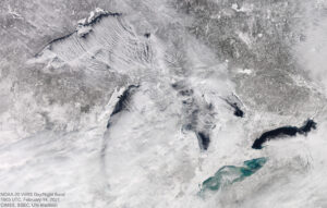
National Oceanic and Atmospheric Administration (NOAA) monitors and reports on the ice coverage of the Great Lakes. NOAA reports total coverage of the Great Lakes is standing at about 32% as of Feb. 12. Historically, much of the major freezing happens in February.

Satellite view of the Great Lakes Region

On Feb. 12, the average concentration of ice on Lake Superior was 23%. Lake Michigan’s ice coverage is currently at 27.9%, and Lake Huron’s coverage is 37.9% at this time. The past week has seen significant ice growth, nowhere more apparent than on Lake Erie, the shallowest of all of the Great Lakes, where the ice coverage is currently at 73.9%. Finally, Lake Ontario ice coverage is 11.6%.

The 2021 ice cover of 32%, the maximum coverage this winter, is significantly lower than the long-term average maximum coverage of 53%. The 2021 amount is higher than the 2017 and 2020 maximums (both about 19.5%) and much lower than the 2018 maximum of 70% and the 2019 maximum of 81%. While there is a large annual variability, across all the Great Lakes the annual maximum ice cover is, on average, 22% lower than it was a half-century ago.

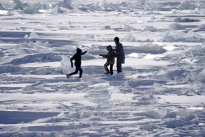
Frolicking on Lake Superior in February. 
Credit: B. Peterson, STAR TRIBUNE

Freezing first occurs along the shoreline, where the water is shallow. Cracks can form in the ice and high winds can push ice floes further from shore. On Feb. 6, 66 people, mostly ice fisherman, had to be rescued from an ice floe on Lake Michigan.

Steve Ackerman and Jonathan Martin, professors in the UW-Madison department of atmospheric and oceanic sciences, are guests on WHA radio (970 AM) at 11:45 a.m. the last Monday of each month.
Category: Climate, Meteorology, Phenomena, Seasons, Uncategorized

Comments Off on How is the ice cover on the Great Lakes?