Why is the high temperature forecast sometimes too high?

We are in the midst of another hot spell here in southern Wisconsin.

NOAA’s smoke forecast vertically integrated from the surface to the top of the atmosphere on July 27, 2021. (Image credit: NOAA)

Last Friday was the first of several days that were forecast to see high temperatures at or above 90 degrees (we’ve had only six through Friday all season!).

The high on Friday only reached 88 as the sky was a bit more obscured than was forecasted.

The obscuring factor was a combination of high cirrus clouds and smoke from the Western wildfires. The first of those factors, high cirrus clouds, is a common summertime suppressor of the high temperature.

Their exact location, timing and duration are very hard to predict accurately and so they are often the primary reason why a given summer day’s high temperature forecast might be too high.

Despite the difficulty of forecasting high clouds, the numerical models used by the National Center for Environmental Prediction (NCEP) are designed to simulate their development through the routine inclusion of humidity, wind and temperature data in the models.

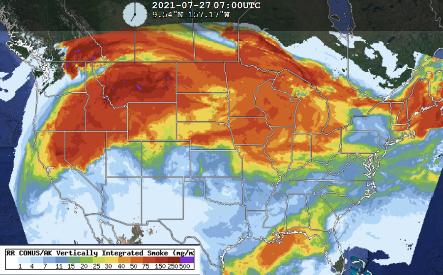
The other factor conspiring to lessen the heat on these several days, wildfire smoke, is not well accounted for in those same models.

Because such large-scale smoke plumes are only episodic it is much more difficult to confidently account for their presence in these forecast models.

Smoke definitely reduces the amount of sunlight that is absorbed at the ground and so conspires to keep the temperature a bit cooler than it might have been in the absence of the smoke.

So, if the forecasted high temperatures over the weekend and early this week seem to be systematically a bit too high, it might well be a direct result of the wildfires that are raging in the Western states.

Steve Ackerman and Jonathan Martin, professors in the UW-Madison department of atmospheric and oceanic sciences, are guests on WHA radio (970 AM) at 11:45 a.m. the last Monday of each month. Send them your questions at stevea@ssec.wisc.edu or jemarti1@wisc.edu.

Category: Uncategorized

Comments Off on Why is the high temperature forecast sometimes too high?

Are there clothes that can cool us down?

There are clothes that have been developed that can keep us warmer. That type of clothing has been around for many years.

We have been less successful at developing clothes that can keep us cool on hot days. The solution has generally been to wear less clothing.

The sun emits a broad spectrum of electromagnetic radiation, including ultraviolet (UV) and near-infrared (NIR). We get sunburned when too much UV radiation falls on our skin and is absorbed. Fabric that reflects UV light helps reduce sun burn and also helps to cool us down.

Fabric that reflects NIR energy doesn’t help keep us cool, as the atmosphere is good at absorbing this type of energy and thus the air around you would warm.

Our bodies also emit electromagnetic energy, some in the form of mid-infrared energy (MIR). The atmosphere is largely transparent to this type of energy, and the MIR we emit goes out to space. When we wear today’s clothes, MIR emitted by our body is absorbed by the cloth and this warms our bodies.

Scientists are developing textiles that transmit MIR. If this could be developed into cloth for summer clothing, MIR energy emitted by our bodies would be transmitted away, helping to keep our bodies cool.

Steve Ackerman and Jonathan Martin, professors in the UW-Madison department of atmospheric and oceanic sciences, are guests on WHA radio (970 AM) at 11:45 a.m. the last Monday of each month. Send them your questions at stevea@ssec.wisc.edu or jemarti1@wisc.edu.

Category: Meteorology, Seasons

Comments Off on Are there clothes that can cool us down?

Is the air really “heavy” on a humid summer day?

As the baseball season reaches its annual All-Star break, perhaps you have noticed (as we have) that baseball broadcasters are beginning to refer to “heavy” air as the summer reaches its peak.

This “heaviness” is sometimes offered as a warning to fans that they should not expect a lot of home runs on a given night.

The fact that high humidity in the summer can sap one’s energy is a familiar physiological reality for almost all of us, and so it almost certainly has a bearing on athletic performance. This impact, however, has nothing to do with the weight of the air that surrounds us.

As it turns out, the exact opposite is actually true. Even if the air were perfectly absent of water vapor, the warmer that air gets the less dense it gets. This means the air is lighter as it warms up.

In fact, anyone who has thought about why a hot-air balloon works is likely to have come to this conclusion at some point.

If we add water vapor to the air, which is common in summer and accounts for the uncomfortable feel of a muggy day, the air gets even lighter. That is because humid air is a mixture of “dry” air and invisible water vapor. Since the dry air has a molecular weight of about 29 grams/mole (1.29 grams/liter) and water vapor has a molecular weight of about 18 grams/mole (0.804 grams/liter), any mixture of dry air and water vapor drops the weight of air below what it would be were it completely void of water vapor.

Thus, the broadcaster’s suggestion that summer air is “heavy” is physically incorrect.

When you hit a baseball, speed, angle, air resistance, and altitude all affect how far it travels. Click on the image to learn more.

Steve Ackerman and Jonathan Martin, professors in the UW-Madison department of atmospheric and oceanic sciences, are guests on WHA radio (970 AM) at 11:45 a.m. the last Monday of each month.

Category: Meteorology, Seasons

Comments Off on Is the air really “heavy” on a humid summer day?

Do car tires protect you from lightning strikes?

Lightning is a huge electrical discharge, or spark, that results from vigorous motions that occur in thunderstorms. While you can be safe in a car in a lightning storm, it is not because of the tires. Rubber tires do act as an insulator but only at low voltages. For comparison, the current in your house is 120 volts and 15 amps, while a typical lightning bolt is about 300 million volts and about 30,000 amps. The voltage in a lightning bolt is too high to be stopped by tires. A lightning strike can blow out your tires or wreck your car’s electronic control circuits.

Inside a car can be a safe place to wait out a lightning storm. If the car is struck by lightning, its metal frame redirects the electrical current around the sides of the car and into the ground without touching the interior contents, including the people inside.

Don’t lean on the doors. The metal frame acts like a Faraday cage, which is a hollow conducting object that protects its interior from electrical fields and currents. Riding around in a convertible, no matter what kind of tires you have, will not protect you, as you are not in a fully enclosed metal cage.

A unique looping lightning bolt captured in Wisconsin by Jerry Zimmer in 2019.

Lightning is very dangerous. About 300 people in the U.S. are injured by lightning each year, and about 62 people are killed. On average there is about one death caused by lightning in Wisconsin annually.

While your chances of getting hit by lightning are only about one in a million in a given year, it is good to keep some safety tips in mind.

Steve Ackerman and Jonathan Martin, professors in the UW-Madison Department of Atmospheric and Oceanic Sciences, are guests on WHA radio (970 AM) at 11:45 a.m. the last Monday of each month.

Category: Meteorology, Phenomena, Weather Dangers

Comments Off on Do car tires protect you from lightning strikes?

Are heat waves and droughts related?

The ongoing heat wave in the western states is shattering hundreds of high temperature records.

Weekly US Drought Monitor Graphic

The extreme heat has now moved into the Pacific Northwest and threatens some all-time records in Seattle and Portland. Seattle has only ever recorded three days over 100 degrees in the last 76 years, but stood a decent chance of seeing three in a row over the weekend.

This extended heat wave is partly a function of the climatology of the western states, partly a function of larger-scale circulation anomalies particular to this June, and partly a function of the gradually warming climate.

It is quite normal for the elevated, often arid, terrain of western North America to support the development of tropospheric-deep anticyclones, or regions of high pressure. This is because the height of the tropopause, the “lid” atop the lowest layer of the atmosphere, the troposphere, is directly tied to the average temperature of the underlying air column. In summer, it is easy to warm the air columns above mountains and produce a locally elevated tropopause. The resulting anticyclone encourages gentle sinking of air which keeps the skies clear and limits precipitation production.

As the underlying ground continues to dry out in the absence of rain, it warms more each day and temperatures start to climb. The same circumstances intensify drought conditions so heat waves and droughts go hand-in-hand as a matter of course.

Global warming has increased the background temperature fractionally and leads to reduction in snowpack, reduction in summer precipitation, and increased aridity in the mountainous regions of western North America.

So, the current heat wave and severe drought are physically interrelated and are supported by the background warming. All of this puts the region at extreme risk, again, for a prolonged and devastating wildfire season.

Steve Ackerman and Jonathan Martin, professors in the UW-Madison department of atmospheric and oceanic sciences, are guests on WHA radio (970 AM) at 11:45 a.m. the last Monday of each month. Send them your questions at stevea@ssec.wisc.edu or jemarti1@wisc.edu.

Category: Climate, Seasons, Severe Weather

Comments Off on Are heat waves and droughts related?