What is a heat dome?

“Heat dome” is a term used explain extreme heat conditions across large geographic regions.

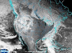
High pressure systems aloft that can create a “cap” that traps heated surface air in place. Heat waves develop as the weather pattern becomes stagnant and the heat builds over numerous days. (Image credit: NOAA/NWS)

The American Meteorological Society maintains a glossary of meteorological terms and defines a heat dome as, “An exceptionally warm air mass at middle latitudes during the warm season that that is associated with a synoptic-scale area of high pressure aloft. This area of high pressure aloft can have a doming effect on the warm air mass below by suppressing rising motion and the development of clouds and precipitation.” This is not the same as a heat wave, which is a spell of 3 or more abnormally hot days.

A heat dome develops when a ridge of high pressure builds over an area and resides there for a week or more. High pressure is associated with very few clouds and lots of sunshine, leading to warm temperatures near the surface. The sinking motion in the high pressure prevents warm air near the surface from rising. This subsidence motion causes further warming of the air by compression. Unless the upper atmospheric pattern changes, the high pressure will continue to exacerbate the hot conditions. The ground also warms and loses moisture, which can lead to drought conditions and the risk of wildfires. The term “ring of fire” is a weather term that is a related to heat dome, as it describes thunderstorms that develop at the boundaries of the heat dome.

Hot and humid conditions during a heat dome can lead to heat-health issues. When our bodies get hot, we cool down by sweating. The sweating does not directly cool our bodies; it is the evaporation of the sweat that cools us. If the air has a high humidity, then the rate of evaporation is reduced, hampering the body’s ability to maintain a constant internal body temperature.

Steve Ackerman and Jonathan Martin, professors in the UW-Madison department of atmospheric and oceanic sciences, are guests on WHA radio (970 AM) at noon the last Monday of each month. Send them your questions at stevea@ssec.wisc.edu or jemarti1@wisc.edu.

Category: Meteorology, Phenomena, Severe Weather

Comments Off on What is a heat dome?

How is rainfall intensity changing?

NOAA maintains observations of temperature and precipitation extremes in the U.S. The data indicate that cold extremes in the U.S. have become less frequent. Since the 1930s, there have been many more record-high temperatures compared to record-low temperatures. With warmer temperatures, the amount of precipitable water in the atmosphere also increases.

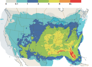
Extremely heavy rainfall is increasing across the United states. This map shows observed percent changes in total precipitation falling on the heaviest 1% of rainy days from 1958–2021. Numbers in black circles depict percent changes at the regional level. (Image credit: Fifth National Climate Assessment)

Consistent with the increased atmospheric moisture, rainfall and extreme precipitation events have also increased. Almost all areas in the U.S. exhibit increases in heavy precipitation, with the largest increases in the Midwest (45% increase) and Northeast (60% increase). The Northwest has the smallest increase (1%) increase followed by the Western regions (17% increase).

A rain day is defined as a period of 24 hours in which 0.01 inches or more of rain is recorded. The intensity of rainfall can be classified as: “light,” the rate of fall varying between a trace and 0.10 inch per hour; “moderate,” from 0.11 to 0.30 inch per hour; and “heavy,” 0.30 inch per hour.

Recent observations and studies suggest shifts in rainfall intensity. A recent study investigated daily precipitation intensity distribution from 1951–1980 and 1991–2020. They grouped the data for these two 30-year time periods according to 17 climate regions of the United States. Regions in the central and eastern U.S. show a consistent increase in average precipitation and its variability. Changes are mixed in the western U.S. The study also quantified a shift in the number of low precipitation events to the number of higher intensity events.

Changes in the rainfall distribution has implications for water management, agriculture, and potential flood risk. NOAA’s sustained observations and research are critical to observing and understating why extreme events are changing now and how they may change in the future.

Steve Ackerman and Jonathan Martin, professors in the UW-Madison department of atmospheric and oceanic sciences, are guests on WHA radio (970 AM) at noon the last Monday of each month. Send them your questions at stevea@ssec.wisc.edu or jemarti1@wisc.edu.
Category: Climate, History, Meteorology

Comments Off on How is rainfall intensity changing?

What is a mesoscale convective complex?

Ordinary thunderstorms are a few miles in diameter and exist for less than an hour. The life cycle of an ordinary thunderstorm contains three stages: cumulus, mature and dissipating.

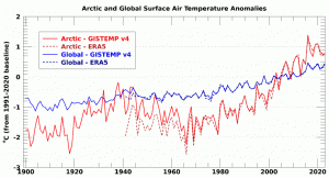
A mesoscale convective complex covers a large area, roughly 40,000 sq. mi., or roughly the size of Iowa. (Image credit: CIMSS)

The cumulus stage is the initial stage of a thunderstorm as warm moist air near the ground rises. The mature stage of an ordinary thunderstorm begins when precipitation starts to fall from the cloud. During the mature stage, the thunderstorm produces the most lightning, rain, and can produce even small hail. The dissipating stage of a thunderstorm occurs when the updraft, which provides the required moisture for cloud development, begins to weaken and collapse. During this stage, the downdraft dominates the updraft and the storm begins to disappear.

Groups of these ordinary single-cell thunderstorms often join into larger systems and are generically referred to as mesoscale convective systems, or MCSs. A mesoscale convective complex, or MCC, is an example of a MCS. It is a complex of individual thunderstorms that covers a large area, about 40,000 square miles, in an infrared satellite image, roughly the size of the entire state of Iowa. In satellite images, MCCs appear as a cluster of thunderstorms that give the appearance of a large circular storm.

MCCs are longer lived than ordinary thunderstorms and last for more than six hours. MCCs often begin forming in the late afternoon and evening and reach mature stages during the night and toward dawn. A MCC is a multicell storm composed of convective cells in different stages of their life cycles. For MCCs to exist, the individual thunderstorms of the system must support the formation of other convective cells. The downdrafts of individual cells of the MCC form and enhance the updrafts of neighboring cells.

Steve Ackerman and Jonathan Martin, professors in the UW-Madison department of atmospheric and oceanic sciences, are guests on WHA radio (970 AM) at noon the last Monday of each month. Send them your questions at stevea@ssec.wisc.edu or jemarti1@wisc.edu.
Category: Meteorology, Severe Weather

Comments Off on What is a mesoscale convective complex?

Who conducts the National Climate Assessment?

The U.S. National Climate Assessment is mandated by the Global Change Research Act of 1990. The assessment has been conducted about every four years since 2000 and is an authoritative scientific analysis of climate change risks, impacts, and responses in the U.S.  The resulting report, mandated by Congress, explains how climate change affects every region of the U.S.

The nation completed its fifth National Climate Assessment (NCA5) in November 2023. The assessment results from an extensive process that includes internal and external review from federal agencies, the public, and external peer review by a panel of experts. The National Oceanic and Atmospheric Administration (NOAA) is the administrative agency for NCA5 and certifies that the report meets the standards required by the  Information Quality Act and Evidence Act.

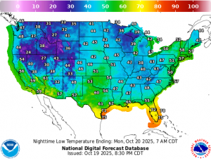
The NCA5 adds further scientific documentation that our planet is warming at an unprecedented rate. Earth’s average surface temperature has risen almost 2F since the late 19th century. Human activity is the principal cause. The science explaining how fossil fuels contribute to climate change has been clear for decades. The NCA5 documents the ways in which the U.S. is experiencing the results of climate change and assesses those risks, challenges, and opportunities. The documented warming affects agriculture, forests, water quality, and the way we live. 

The Trump administration is dismantling the government’s ability to monitor a rapidly changing climate. Experienced experts working on the next national assessment were dismissed in April by the Trump administration. The administration also pulled down the federal website that houses national climate assessments and purged the phrase “climate science” from government websites. The president’s proposed budget eliminates funding for weather and climate research. The administration dismisses the threats posed by climate change and is largely disregarding the future impact and economic cost of climate change by their actions.

Steve Ackerman and Jonathan Martin, professors in the UW-Madison department of atmospheric and oceanic sciences, are guests on WHA radio (970 AM) at noon the last Monday of each month. Send them your questions at stevea@ssec.wisc.edu or jemarti1@wisc.edu.
Category: Climate, History

Comments Off on Who conducts the National Climate Assessment?

What is a landspout?

Landspouts can occur in cumuliform clouds without the parent cloud rotating. Typically, these occur along weather boundary where air converges under weak vertical rotation. The convergence of air at the boundary forces it up forming a cloud and this updraft stretch the rotation increasing its spin. (Photo credit: NOAA/NWS)

According to the American Meteorology Society’s glossary, a landspout is a colloquial name for a small tornado whose vorticity (a vector that measures local rotation in a fluid flow) originates in the boundary layer and has a parent cloud in its growth stage. Landspouts occur when colliding winds at the surface begin to make a vortex and then a developing thunderstorm passes overhead. The updrafts from that thunderstorm draw the rotating vortex upward and give it a tornado-like appearance. While relatively weak compared to traditional tornadoes, landspouts can be strong enough to cause damage and warrant caution.

The term “landspout” was coined by atmospheric scientists in the 1980s to describe a type of vortex associated with thunderstorms that do not possess a strong mid-level mesocyclone. A mesocyclone is a cyclonically rotating vortex, around 2–10 km in diameter, in a convective storm.  Strong tornadoes form in mesocyclones.

Landspouts are generally short lived, usually lasting less than 15 minutes, and have a short track. They can occur under rapidly developing cumuliform clouds and along a surface boundary, or at a point where two boundaries collide. As the rotation occurs at low levels in the atmosphere, the resulting vortex does not extend very far up into the cloud. Landspouts form from a ground circulation that is sucked up into a storm, while tornadoes form from a rotating supercell thunderstorm. Tornadoes form in thunderstorms and reach down to the ground. They can tap energy sources, such as the jet stream, that are far more powerful than those energy sources at the ground.

Tornadoes form when winds at the cloud-level begin to spin and the cloud rotation can be detected using Doppler radar. Landspouts form at the ground and are often below the radar beam and therefore go undetected.

Steve Ackerman and Jonathan Martin, professors in the UW-Madison department of atmospheric and oceanic sciences, are guests on WHA radio (970 AM) at noon the last Monday of each month. Send them your questions at stevea@ssec.wisc.edu or jemarti1@wisc.edu.

Category: Meteorology, Phenomena, Severe Weather

Comments Off on What is a landspout?