
When does the first freeze occur in fall?

The cooldown that we enjoyed over the weekend, after the prolonged warm and humid spell that began September, got us thinking about the inevitable first morning with a temperature below 32 degrees.

We are less than two weeks away from the autumnal equinox, the last day until late March on which the day is at least as long as the night.

In the last 73 years, since the official temperature for Madison has been recorded at the airport, the average date of our first 32-degree night is Oct. 1. However, the earliest such night occurred on Sept. 11, 1955 – after a summer in which a record 40 days with a high temperature of 90 were recorded. This early freeze was nearly equaled by 1962 and 1963, when it occurred on Sept. 12.

More recently, the only fairly early date for the first freeze was Sept. 16, 2007. The latest such night also occurred in the 1950s – Oct. 17, 1959 – with a more recent competitor landing on Oct. 14, 2005.

Interestingly, for a period of 23 years (1940-1963) we have simultaneous records from the official recording site that used to be located in Downtown Madison. The average first freeze at that location is much later, around Oct. 20. The earliest and latest dates at that site are also quite different.

So, though on average the first freeze occurs about 10 days after the equinox at the airport, your own home may record a substantially different first freeze date.
Category: Climate, Seasons

Comments Off on When does the first freeze occur in fall?

Is the smoke from western forest fires affecting our weather?

This year there have been many fires on the west coast of the U.S. and Canada.

Most of these fires are in remote regions and were started by lightning strikes. This smoke has drifted over our region. It will not have much of an effect on our temperature or precipitation. However, official weather reports include observations on sky conditions and visibility.

The smoke can cause the sky to appear hazy, even if the smoke is high above the ground. When the smoke is thick it can cause brilliant red sunsets and sunrises. When light beams interact with particles suspended in air, the light can be scattered or absorbed.

The amount of light that is being scattered is a function of the number of particles and the size of the particle relative to the wavelength of the light falling on the particle. Small particles, like those smoke is composed of, scatter blue light. So, as the sun sets and its rays pass through the smoke plume, all the blue lights are scattered out of the path between the setting sun and your eyes, leaving just the red and orange colors.

This results in the sun having a bright red color when it is low on the horizon. Recently, the smoke above us has been thick enough that the red sun disappeared from view before it set below the horizon.

If the winds are right, the smoke can be transported down to the ground. This can cause a reduction in air quality. The small particles that make up the smoke can cause respiratory problems, particularly for children, the elderly and people with asthma.

Category: Meteorology, Phenomena

Comments Off on Is the smoke from western forest fires affecting our weather?

How was our summer weather?

The average global temperature of July set highs — it was the warmest month on record since record keeping began in 1880.

The observed ocean surface temperature was the highest for any month in the 1880-2015 record period. The average temperatures over land were also above the average for the 20th century, ranking as the sixth-warmest July since 1880.

The July globally averaged land surface temperature was 1.73 degrees above normal. And so far, 2015 (the months of January through July) is at the all-time record warm temperature for the globe.

Regionally, however, southern Wisconsin’s mean temperature for July 2015 was about 2 degrees below the average for the 1971-2000 record period.

Our August temperature and precipitation is also below the average for the past 30 years.

Preliminary analysis looks like our summer mean temperature for this year will be below normal. We had five days with the temperature at or above 90. The outlook for September is for continued cool temperatures in our region.

The summertime precipitation for southern Wisconsin was below normal. There were four days in Madison when the precipitation was more than 1 inch. Though Madison is not in drought conditions, there is a short-term drought across southwestern Wisconsin and along the shore of Lake Superior in northern Wisconsin.

Category: Climate, Seasons

Comments Off on How was our summer weather?

What caused the recent weather extremes?

The National Weather Service in Milwaukee confirms that three separate tornadoes occurred in our state on Tuesday.

EF-1 tornadoes, with winds estimated at up to 110 mph, struck Lake Geneva and a location just outside of Big Bend. An EF-0 tornado, with winds estimated at up to 80 mph, struck southwest Waukesha.

These storms occurred at the end of the most prolonged heat wave of the summer. From Aug. 14-16, we had high temperatures in Madison of 92, 91, and 88, respectively – marking the only time yet this summer where we had consecutive days above 90.

By Wednesday, our high temperature was only 70 — our lowest high since July 8 — and the weather had turned astonishingly autumnal.

What was responsible for the fairly rapid fall of temperature? The first fall-like cyclone of the year raced across the Great Lakes states Tuesday night and Wednesday dragging the first fall-like cold front along with it. Behind the front the air is substantially colder and, perhaps most noticeably, much drier. At this time of year, the path along which such storms progress from west to east, the so-called storm track, begins to migrate southward as the northern latitudes cool in response to diminished daylight.

The good news, for now, is that the return of southerly winds and warmer temperatures is also quick when the storm track is right over Wisconsin. Later in the fall and winter, when the storm track is well to our south, the passage of storms leaves us in the cold air for much longer.

Category: Meteorology, Seasons, Severe Weather

Comments Off on What caused the recent weather extremes?

What is the hydrologic cycle?

Sitting nearly in the middle of the vast North American continent, Madison has what is known as a continental climate.

Continental climates are characterized by large annual extremes in temperature and humidity as well as very distinct seasons. The continental nature of Madison’s climate is what makes a year’s worth of weather in Madison usually a lot more varied than a year’s worth in Seattle, for instance.

There is an astounding 144 degrees difference between the all-time highest (107 on July 13, 1936) and all-time lowest (-37 on January 31, 1951) temperature in Madison.

In addition, the amount of water vapor in the air can range from the barely detectable level in the midst of a deep winter cold spell to as much as 3.5 percent of every breath you take during a severe July heat wave.

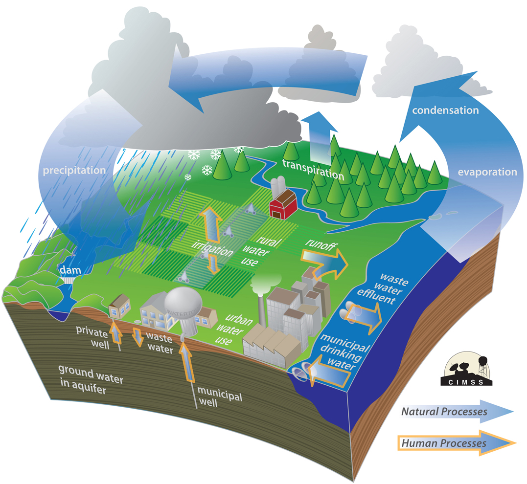
No matter what the season, the vast majority of the invisible water vapor in the atmosphere is contained in the lowest mile or two from its source at the surface. At any one instant, the Earth’s atmosphere contains 37.5 million billion gallons of water vapor — enough to cover the entire surface of the planet with one inch of rain if condensed.

This amount is recycled, through evaporation powered by the sun, 40 times each year in what is known as the hydrologic cycle. In each of these 40 cycles, enough energy is expended to power the United States — the largest consumer of energy in the world — for 3,441 years. That’s a truly astounding amount of energy.

Category: Meteorology, Seasons

Comments Off on What is the hydrologic cycle?