
Why are cold snaps in autumn so short-lived?

Over the past weekend, southern Wisconsin experienced its first cold snap of the season with widespread morning lows in the upper 20s on Friday and Saturday mornings.

Often, cold snaps in autumn are short-lived, as this recent example was, affecting usually one or two nights at most.

There are a variety of reasons for this brevity. First, cold snaps at this time of year require a substantial southerly excursion of cold air from high latitude Canada to get us cold. Though the Arctic night creeps ever farther south each day after the autumnal equinox, its southerly progress is slow.

Consequently, cold air production is limited to the very highest latitudes well into November, which means that any cold air that makes it as far south as Madison is not well connected to a broader reservoir of cold air that would allow the cold to remain.

Second, there is little snow on the ground even in central Canada at this time of year and so the cold air that does migrate southward is modified (warmed) to a greater degree on that migration at this time of year than in the late fall and winter when snowcover is widespread.

Third, the lack of snow on the ground in Madison itself limits the longevity of cold snaps. This is even true in the wintertime. Overnight cooling over a snowfield can reinvigorate the chill of a cold snap and render it longer lasting as a result. So, if you were complaining about the cold this weekend, be glad we are still in October and much more likely to experience a quick rebound.
Category: Meteorology, Seasons

Comments Off on Why are cold snaps in autumn so short-lived?

What is a 100-year flood?

A flood occurs when water flows into a region faster than it can be stored in a lake or reservoir, absorbed into the soil, or removed by runoff into a drainage basin.

There are several conditions that can result in flooding: a long-lasting rainfall over a watershed, intense thunderstorms, or rainfall that causes rapid snow melt.

Because floods result under different circumstances and in different places, their impact varies. The term “100-year flood” allows us to place a particular flooding event in context with other floods.

It is wrong to think that a 100-year flood happens only once every 100 years. The phrase “100-year flood” describes the estimated probability of a flood event happening in any given year. A 100-year event has a 1 percent chance — or 1-in-a-100 chance — of occurring in any given year. While not likely, two 100-year flooding events can occur within a month of each other.

Scientists collect data on how frequently different sizes of floods occur and the time between these floods. They use this data to calculate the probability that a flood of a particular size will be equaled or exceeded during any year.

The term “100-year flood” is a statistical designation of an unlikely event. Statistically, a 100-year flood has approximately a 63 percent chance of occurring in any 100-year period, not a 100 percent chance of occurring.

Extreme and unlikely values are important for assessing the risk of unusual events. In the 1960s, the federal government decided to use the statistics of the 100-year event as the basis for the National Flood Insurance Program. These data continue to be used in determining flood insurance rates.

Category: Climate, Meteorology, Severe Weather

Comments Off on What is a 100-year flood?

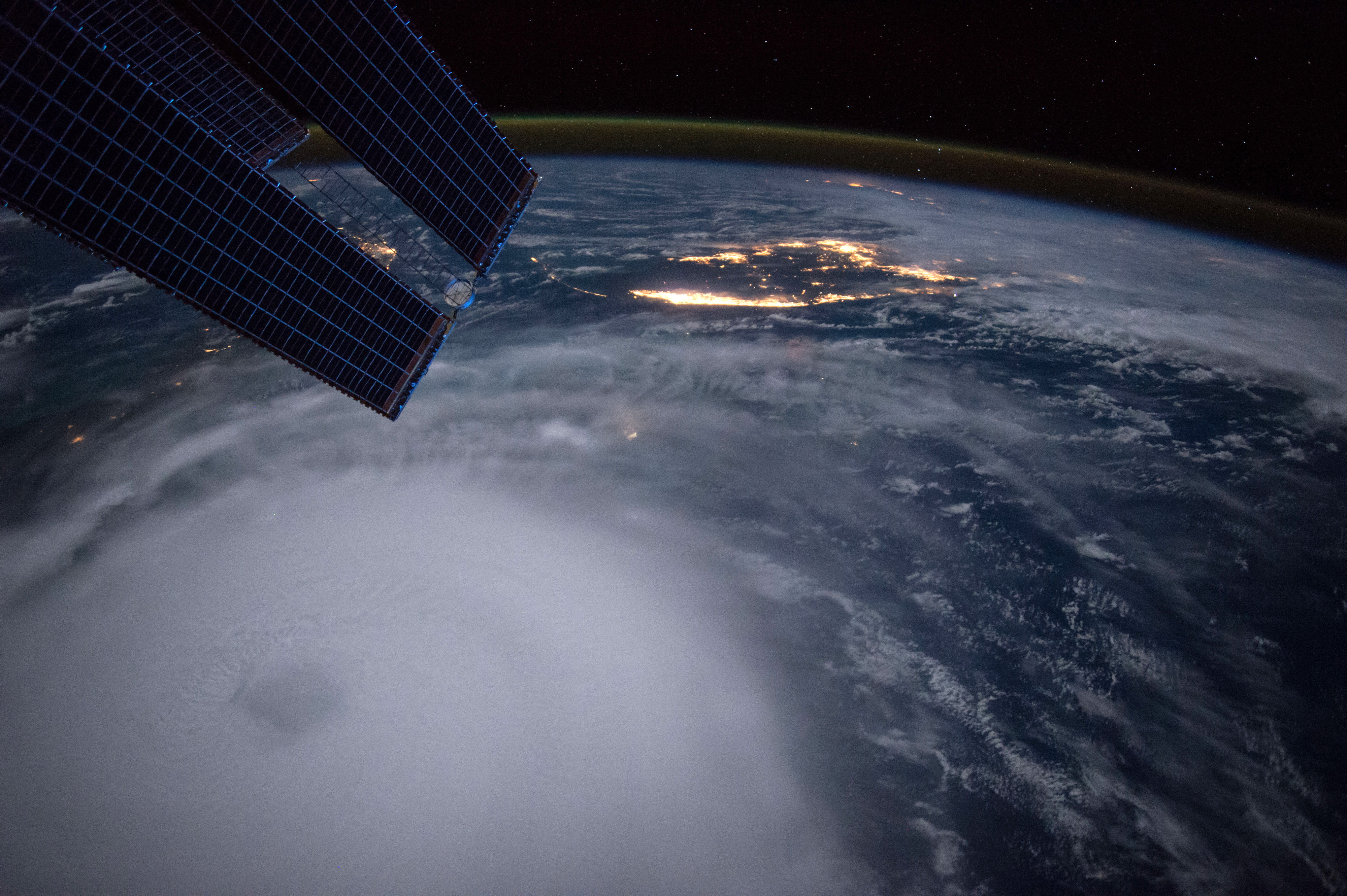
Is hurricane forecasting improving?

Hurricane Joaquin taken at night by Astronaut Scott Kelly from the International Space Station on 2 Oct 2015.

Hurricane Joaquin taken at night by Astronaut Scott Kelly from the International Space Station on 2 Oct 2015.

The improvement in hurricane track is due to a number of factors. We now have better and more satellite observations, new observations from drones carrying weather instruments, and more aircraft with better instruments observing hurricanes.

Super computers that are faster improve forecast models by allowing more energy and dynamic processes to be incorporated more explicitly into the forecast. Due to improved observations, we can include better descriptions of the initial state of the atmosphere into the models, which leads to more accurate predictions of a storm’s behavior.

Forecasting the intensity of a hurricane hasn’t improved much in the last two decades, so work remains to be done in that area. This lack of improvement is likely a result of our lack of understanding of the physics that control these massive weather systems.

Hurricanes are complex, large and powerful, which makes them difficult to study. While we still lack the ability to accurately forecast hurricane intensity, our understanding of how hurricanes evolve, how they interact with dust outbreaks from Africa, and how a new eye begins to develop around the old eye of a hurricane, has grown substantially.

Category: Meteorology, Severe Weather, Tropical

Comments Off on Is hurricane forecasting improving?

What does El Nino mean for southern Wisconsin’s winter this year?

El Nino is an atmosphere/ocean phenomenon in which the waters of the eastern equatorial Pacific Ocean are warmer than normal for an extended period of time.

This unusual warmth forces changes in the distribution of deep convective thunderstorms over the tropical ocean which, in turn, affect the position and strength of the jet stream. Since the jet stream acts a conduit of winter storms and can regulate intrusions of cold arctic air, changes in jet stream characteristics can have a profound influence on our winter weather.

Generally, El Nino is associated with warmer than normal winters in the western Great Lakes states so we can reasonably expect that this coming winter will be milder than the last two. Though there is a tendency for a bit more precipitation in El Nino winters here, since it is usually warmer than normal, there is usually less than the normal amount of snow.

Currently, the sea surface temperature data in the equatorial Pacific suggest that this year’s El Nino may be the strongest on record. If it continues to grow in intensity as predicted, our winter could become memorably mild. One of us recalls throwing rocks into Lake Mendota in late February 1998, near the end of the last really strong El Nino winter, and imagining that might never happen again. Perhaps it will.

Category: Meteorology, Phenomena, Seasons

Comments Off on What does El Nino mean for southern Wisconsin’s winter this year?

When is the autumnal equinox?

On Wednesday morning, we will officially enter fall as the autumnal equinox occurs at 3:20 a.m.

On Wednesday, in common with every location on Earth, we will enjoy exactly 12 hours of daylight and 12 hours of night.

Of course, 12 hours of daylight in Madison (latitude 43N) is substantially different from 12 hours of daylight at the North Pole (latitude 90N) where the sun will barely be visible above the horizon for the 12 hours of “daylight.” On the very next day, the sun will not appear above the horizon at the Pole and will not come back for six months. As the days march on, the same fate will gradually overtake other latitudes in the Northern Hemisphere until by Dec. 21, the sun will not rise even at 66.5N.

The primary means by which air is warmed is by its contact with the surface of the Earth that, when the sun shines, can absorb radiation and heat up.

A leading consequence of the shortening days, especially at high latitudes, is that air masses can begin to get really cold again. Even as we enjoy one the warmest Septembers in quite some time, the areal extent of the cold wintertime air is growing at high latitudes.

As it encroaches southward from the Pole, the polar jet stream, always on the warm edge of the coldest arctic air, begins to take up residence at lower latitudes bringing with it the powerful storms of late autumn and winter.

So, enjoy these beautiful early fall days we are having in Madison because the cosmic deck is stacked against us.

Category: Meteorology, Seasons

Comments Off on When is the autumnal equinox?