Are thunderstorms dangerous to aircraft?

Crews work to de-ice a plane at O'Hare International Airport in Chicago on Feb. 1, when a snowstorm forced the cancellation of about 2,000 flights in the Midwest, most of them at O'Hare. Ice on the wings can disrupt the lift of the plane causing it to lose altitude.

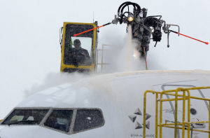
Crews work to de-ice a plane at O’Hare International Airport in Chicago on Feb. 1, when a snowstorm forced the cancellation of about 2,000 flights in the Midwest, most of them at O’Hare. Ice on the wings can disrupt the lift of the plane causing it to lose altitude.

On Aug. 7, an Airbus A320 carrying 138 people encountered hail within a rapidly developing thunderstorm that could not be avoided. No one was injured although the pilot made an emergency landing at Denver airport and the nose of the plane suffered hail damage.

Turbulence is also a danger to high-flying jets. Turbulence generated by a thunderstorm can cause the aircraft to violently shake even if only flying close to a storm. Lightning can strike a plane, but generally doesn’t do damage as the bolt enters the aircraft extremities, such as the nose, tail or wing tips.

Icing is particularly dangerous to planes. When the plane is flying in temperatures below freezing while inside a cloud, very cold liquid water drops freeze onto the aircraft as soon as they strike the plane. Ice on the wings can disrupt the lift of the plane, causing it to lose altitude.

The downdrafts of a storm can be very dangerous to aircraft on take-off or landing. A downdraft can result in rapid wind shift from a tail wind to a head wind causing the aircraft to rapidly lose altitude. Fortunately, airports are equipped with instruments that can detect hazardous conditions and send warnings that keep the planes from encountering these dangerous conditions.

Category: Uncategorized

Comments Off on Are thunderstorms dangerous to aircraft?

What is the hydrologic cycle?

Sitting nearly in the middle of the vast North American continent, Madison has what is known as a continental climate.

Continental climates are characterized by large annual extremes in temperature and humidity as well as very distinct seasons. The continental nature of Madison’s climate is what makes a year’s worth of weather in Madison usually a lot more varied than a year’s worth in Seattle, for instance.

There is an astounding 144 degrees difference between the all-time highest (107 on July 13, 1936) and all-time lowest (-37 on January 31, 1951) temperature in Madison.

In addition, the amount of water vapor in the air can range from the barely detectable level in the midst of a deep winter cold spell to as much as 3.5 percent of every breath you take during a severe July heat wave.

No matter what the season, the vast majority of the invisible water vapor in the atmosphere is contained in the lowest mile or two from its source at the surface. At any one instant, the Earth’s atmosphere contains 37.5 million billion gallons of water vapor — enough to cover the entire surface of the planet with one inch of rain if condensed.

This amount is recycled, through evaporation powered by the sun, 40 times each year in what is known as the hydrologic cycle. In each of these 40 cycles, enough energy is expended to power the United States — the largest consumer of energy in the world — for 3,441 years. That’s a truly astounding amount of energy.

Category: Meteorology, Seasons

Comments Off on What is the hydrologic cycle?

Can we predict tornadoes?

Photo of Stoughton Tornado, 2005.

The tornado that struck Stoughton on August 18, 2005, is seen southwest of Highway 51 as it approached the city. Advances in radar technologies have helped to identify storms that are producing a tornadoes, or about to produce a tornado. Photo credit: Dale Bernstein NOAA/NWS

A tornado is a powerful, narrow column of winds that rotate around a center of low pressure. The winds inside a tornado spiral inward and upward, often exceeding speeds of 300 mph.

We cannot always tell if a developing storm will produce a tornado. Advances in radar technologies have helped to identify storms that are producing a tornadoes, or about to produce a tornado.

We do know the necessary conditions needed for tornado formation. And we are getting better at predicting those conditions a few days in advance, enabling forecasters to identify counties where there is a threat of severe weather sometimes as many as three days in advance.

For a thunderstorm to produce a tornado requires warm humid air near the surface with cold dry air above.

These conditions make the atmosphere very unstable, in the sense that once air near the ground is forced upward, it moves upward quickly and forms a storm.

Severe thunderstorm conditions also include a layer of hot dry air between the warm humid air near the ground and the cool dry air aloft.

This hot layer acts as a lid that allows the sun to further heat the warm humid air — making the atmosphere even more unstable.

To form a tornado, the host thunderstorm must also rotate. From below, a rotating bottom of the cloud looks like someone is stirring the storm from above. This happens in a storm when wind at the ground is moving in a different direction and speed than the air above.

The change in wind speed and direction with height is known as wind shear. Both wind shear and atmospheric instability are needed for tornado formation.

Category: Meteorology, Phenomena, Severe Weather, Weather Dangers

Comments Off on Can we predict tornadoes?

When is the warmest day of the year?

As we move past mid-July, the climatologically warmest day of the year in Madison (i.e. the day with the highest average high temperature) is in our immediate wake.

Every 10 years the 30-year climatology is updated in the following way: In 1972, we used the 1941-1970 average as climatology. By 1982 we were using the 1951-1980 average as climatology. Currently, we are using the 1981-2010 average as climatology.

Though the particular averaging period has changed over the past four decades, the average warmest day of the year has consistently fallen around July 15.

This summer we haven’t had much in the way of heat, recording only two days with a temperature at or above 90 degrees (June 9 at 90 and Friday at 91).

June was just 0.1 degrees above normal — mostly as a consequence of warmer-than-normal overnight low temperatures — and July has averaged 6.2 degrees cooler than normal through the first third of the month.

The coolness thus far does not mean that the rest of the summer will remain moderate, as only 12 of the last 30 summers have recorded more days at or above 90 degrees before July 15 than after it. In fact, in the 13-year period from 1985-97, nine summers recorded the bulk of their 90-degree days before mid-July. From 1998 to 2014, only three such summers have occurred (2007, ’08, and ’12). So, front-loading 90-degree days in the summer has become increasingly rare this century. We’ll see what 2015 brings in the next few weeks.

Category: Meteorology, Seasons

Comments Off on When is the warmest day of the year?

Why have the skies been so hazy?

The state Capitol is enshrouded in haze July 7 as lingering smoke plumes from wildfires in Canada continue to move through the area. Photo Credit:  John Hart, Wisconsin State Journal

The state Capitol is enshrouded in haze July 7 as lingering smoke plumes from wildfires in Canada continue to move through the area.
Photo Credit: John Hart, Wisconsin State Journal

Summer skies often look hazy because of the high humidity, which condenses in the sky and forms small liquid water particles that scatter light, creating that hazy effect.

But there’s a different reason our skies have not been a nice blue color when they’re cloud-free: smoke.

It’s coming from wildfires in the forests of the Northwest Territories in Canada, which were started naturally by lightning strikes. The winds have moved this smoke our way, defining which areas would be affected by the smoke.

In early July, the winds transported the dense smoke south and southeast; the leading edge of the smoke made it as far south as Iowa and northern Illinois. While most of the smoke is high above ground, some smoke reached the ground.

Last week the smoke was so thick and widely spread that some could smell it, and triggered a poor air quality warning for southern Wisconsin. Surface visibility was reduced to 3-5 miles at some locations in North Dakota.

The smoke has made for some very red suns during sunset, particularly last Tuesday and Wednesday.

You may have noticed that if smoke is not too thick, it takes on a bluish tint. That is because the small smoke particles scatter blue colors in sunlight. Smoke above us will scatter the blue colors in all directions, eventually removing nearly all the blue light from sunlight. So, as you look at the sun as it begins to set, the smoke removes all the blue light from the sun’s rays heading toward your eyes, leaving the reds and oranges to transmit through the atmosphere. This makes the sun appear very red.

Category: Meteorology, Phenomena, Weather Dangers

Comments Off on Why have the skies been so hazy?