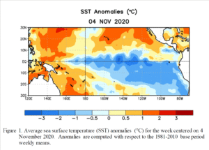
Both La Niña and El Niño refer to big changes in the sea-surface temperature across much of the eastern tropical Pacific Ocean.
The water temperatures off the west coast of South America are typically 60 to 70 degrees. During a La Niña, these waters get as much as 7 degrees colder. These La Niña conditions recur every few years and last nine to 12 months, though some events have lingered for as many as two years. This cooling results from a strengthening of the winds over the tropical Pacific and its interaction with the underlying ocean waters.
This year, a La Niña event developed in the tropical Pacific from August to September. The latest forecasts indicate a high likelihood — 90% — of tropical Pacific sea surface temperatures remaining at La Niña levels until the end of the year. Most models indicate the 2020-21 La Niña is likely to be a moderate to strong event.
Wisconsin winters tend to have more precipitation and near-average temperatures during a typical La Niña. Above-average precipitation is expected over the Great Lakes from December through February.
The strength of a La Niña varies from year to year. A strong La Niña occurred in 2007-08, when Madison had more than 100 inches of snow, shattering the all-time seasonal snowfall record for the city.
Elsewhere in the United States, La Niña conditions in winter mean warmer and drier than normal weather in the Southeast and Southwest and colder than normal weather in the Northwest. With a well-established La Niña, the Pacific Northwest is wetter than normal in the late fall and early winter.

