Is another transition around the corner?

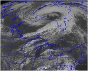
Convective clouds such as these from a storm over Hudson Bay in Canada last week can drop large amounts of rain very quickly. (Photo credit: Steve Ackerman, UW-Madison)

This classic comma shaped cloud, also called a mid-latitude cyclone, deepened over Hudson Bay Canada during mid-August 2016.
(credit: Steve Ackerman, CIMSS)

As we head into the second half of August a subtle transition in our weather begins to occur — one that is probably hard to detect at first but that eventually becomes very obvious and then lasts for approximately eight months.

We are not talking about the gradual reduction in daytime high temperatures or the increasingly cooler to cold nights, though these are also beginning to invade.

Instead, we are talking about the nature of the storms that deliver our precipitation.

Throughout the summer, most of our precipitation comes in the form of thunderstorms, wherein large amounts of precipitation fall in a short amount of time from what we call convective clouds.

Most often these storms have life cycles of only a few hours and drop precipitation over a relatively small area.

These characteristics also make the exact timing and location of summertime precipitation difficult to forecast.

As we transition to late summer/early autumn, the thunderstorm frequency abruptly decreases and precipitation tends to occur in persistent, light to moderate rain events that will sometimes last an entire day.

This mode of precipitation is associated with the passage of what are known as mid-latitude cyclones — storms that live for over a week, during which time they can cover an area the size of 10 states and characteristically take on a comma-shaped appearance in satellite imagery.

As they progress across the country, these mid-latitude cyclones can drop precipitation (rain or snow) over enormous portions of the country.

Though not entirely missing from summertime precipitation, such events are definitely the exception rather than the rule in the summer.

This past week, the first really well developed such storm of the season paraded across Hudson’s Bay in Canada and another one like it is poised to do the same late this week.

Category: Climate, Meteorology, Seasons

Comments Off on Is another transition around the corner?

Has global warming stopped?

In a recent interview on the Glenn Klein Show on WRJN radio, U.S. Sen. Ron Johnson, R-Oshkosh, asserted that “the climate hasn’t warmed in quite a few years … that is proven scientifically.”

This statement is entirely untrue but echoes a line of argument that many climate change and global warming skeptics have introduced into the discussion for a number of years. The so-called “global warming hiatus” argument suggests that since the beginning of the present century there has been a slower rate of increase in the global average surface temperature than climate models suggested would be the case.

This is very different from saying that the warming has stopped.

In fact, a recent analysis of 67 years of continuous temperature data by UW scientists has demonstrated that the areal extent of the cold air at 1 mile above the ground during Northern Hemisphere winter has systematically decreased in that time period and that two of the last three winters have had the smallest such areal extent in the entire record.

There is no question that the air temperature just above the surface is continuing to warm at an alarming rate — even in wintertime.

The U.S. National Centers for Environmental Information issued a new State of the Climate report confirming that 2015 surpassed 2014 as the warmest year since at least the mid- to late 19th century. This scientifically accepted report is based on contributions from scientists from around the world and reflects tens of thousands of rigorous measurements. The globally averaged sea surface temperature was also the highest on record, breaking the previous mark set in 2014.

In a clear example of what President Abraham Lincoln intended when he established the National Academy of Sciences, the scientific community has contributed to our nation’s response to this threat by endeavoring to better understand the many dimensions of this complicated problem. It behoves those who proudly invoke the memory of Lincoln to accede to his original intent.

Category: Climate, Meteorology

Comments Off on Has global warming stopped?

What is a heat wave?

A heat wave is a period of abnormally and uncomfortably hot and usually humid weather. The World Meteorological Organization is specific in its definition by stating that a heat wave is when the daily maximum temperature for more than five consecutive days exceeds the average maximum temperature by 9 degrees.

Heat waves are caused by very hot, stagnant air masses. Regions that suffer under intense hot spells are usually dominated by a surface high-pressure system with a mid-tropospheric ridge aloft. Dew points are also high, and to compound matters, wind speeds are often low.

Clear or partly cloudy skies allow intense solar energy to further heat the ground and the air mass. High humidity and stagnant air reduce the body’s ability to cool down through sweating. Lives are endangered when these conditions persist day and night for several days.

Each summer in the United States, about 175 to 200 deaths are attributed to heat waves. Most of these deaths occur in cities, particularly northern cities. Heat waves also have a strong economic impact.

A prolonged heat wave can cause the widespread use of air conditioning, leading to increased demands for power that stress gas and electric utilities. Transportation can be stymied when highway surfaces and railways buckle and warp in the heat. All types of outdoor work, such as landscaping and construction, experience reduced productivity. Agriculture is especially vulnerable as heat waves stunt crops and kill livestock.

The National Weather Service issues excessive heat warnings within 12 hours of the onset of extremely dangerous heat conditions. This warning is generally issued when the maximum heat index temperature is expected to be 105 degrees or higher for at least two days and nighttime air temperatures will not drop below 75.

These criteria for issuing a warning vary across the country, especially for northern regions that are not used to hot, humid conditions.

Category: Meteorology, Seasons, Weather Dangers

Comments Off on What is a heat wave?

What forces are in play when high winds knock down objects?

Wind is air moving from areas of high atmospheric pressure to low pressure. Violent destructive winds, as well as gentle summer breezes, result from a complex interplay of different forces.

One of these forces results from a pressure gradient, or how fast pressure changes over distance.

When pressure changes rapidly over a small distance, the pressure gradient force is large. Strong winds almost always result from large pressure gradients.

The greater the difference in pressure over a specific distance, the faster the air flows.

Strong winds can also flow out from thunderstorms, which was the case for the strong winds in southern Wisconsin last week that knocked down many tree limbs.

The wind is air in motion. The atmosphere is made up of gas molecules, mostly nitrogen and oxygen molecules.

These gas molecules are constantly in motion and exert a force when they strike an object, like our bodies or tree branches.

The force exerted by the molecules is a function of the speed, number and mass of the molecules.

Since wind is air in motion it has momentum. This momentum is transferred to the object the wind hits.

Thus, the force of the wind can push objects by moving them or knocking them over. Winds moving over and around objects can cause pressure changes around the object, which can also cause it to move.

The molecules that make up the atmosphere are always in motion and some are always striking your body.

Because these molecules are moving in all directions, this force is exerted in every direction and thus there is a balance of forces and the object doesn’t move.

Category: Meteorology, Severe Weather, Weather Dangers

Comments Off on What forces are in play when high winds knock down objects?

Why do thunderstorms scare dogs?

As an impending storm adds drama to the sky, Grant Bunchkowski of Oconomowoc and his dog, Champagne, take in the view near the city's Lac LaBelle in May 2013. Some dogs, like some humans, seem to have a great fear of thunderstorms. An article in "Psychology Today" suggests that some dogs may be seeking an electrical ground during a storm to avoid electrostatic shock. (Photo credit: John Hart, State Journal archives)

As an impending storm adds drama to the sky, Grant Bunchkowski of Oconomowoc and his dog, Champagne, take in the view near the city’s Lac LaBelle in May 2013. Some dogs, like some humans, seem to have a great fear of thunderstorms. An article in “Psychology Today” suggests that some dogs may be seeking an electrical ground during a storm to avoid electrostatic shock. (Photo credit: John Hart, State Journal archives)

Some dogs seem to have a great fear of thunderstorms, as do some humans.

Their fear can drive them through closed doors or windows, or send them cowering to an isolated spot in the house.

While it is unknown why some dogs become desperate to escape the storm, a few studies and personal experiences point to possible reasons for this fear.

Thunder, the loud noise that accompanies lightning, gives this nimbostratus cloud the name thunderstorm. Some dogs don’t like loud sounds, whether from a thunderclap or fireworks.

Static electricity may be another reason. An article in “Psychology Today” suggests that some dogs’ behavior during a storm means they are seeking an electrical ground to avoid electrostatic shock. Those dogs retreat to a particular location in the home during a storm, like the bathroom, bathtub or lean against a radiator.

Thunderstorms are associated with electric field changes. A bolt of lightning is an electrical discharge much like a shock you get when reaching to grab a metal door knob after walking on a rug, just much more energetic.

“St. Elmo’s fire” is evidence of this static electricity associated with thunderstorms. The masts of tall ships may acquire a blue or violet glow in the vicinity of thunderstorms. Pipes in homes and other metal objects have also displayed St. Elmo’s fire. The electric field around the mast, or pipes, causes ionization of the air molecules which generates a faint blue glow that is visible in low-light conditions.

A large dog with thick fur walking around on insulating foot pads is an ideal object for accumulating static charge, which will discharge.

The dog becomes conditioned to expect random shocks during the storm, probably not something anyone wants to endure.

Category: Meteorology, Phenomena, Weather Dangers

Comments Off on Why do thunderstorms scare dogs?