What were the memorable U.S. weather events of 2020?

This NOAA map denotes 16 separate billion-dollar weather and climate disasters that impacted the United States from January-September 2020.

The year 2020 will be noted for some memorable and record-breaking weather.

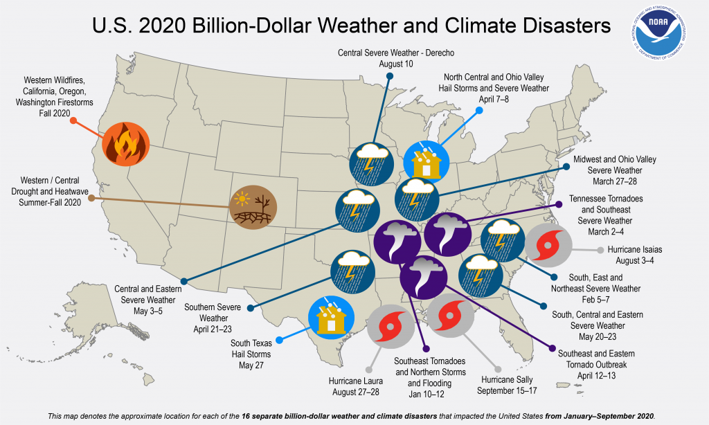
This year saw the most active and seventh-costliest Atlantic hurricane season on record. There were 13 hurricanes, six major hurricanes and 12 storm systems that made landfall in the U.S., causing 409 deaths and more than $40 billion in damages. Hurricane Laura was the strongest land-falling U.S. hurricane of the season; it hit the Louisiana coast with 150 mph winds and higher than 15 feet of storm surge.

A strong derecho moved through Nebraska, Iowa, Illinois, Wisconsin and Indiana on Aug. 10-11. The storm front moved at an average speed of 55 mph with winds peaking at 110–140 mph. It caused severe damage to corn and soybean crops.

There were 1,022 confirmed tornadoes in the U.S. this year, killing 78 people. This included a widespread and deadly tornado outbreak over the southeastern U.S. on Easter Sunday and the following Monday. There were 20 weak tornadoes in Wisconsin, which climatically has an average of 23 a year.

Between Sept. 28 and Oct. 4, there were 232 waterspouts over the Great Lakes. There was also another waterspout outbreak on the Great Lakes between Aug. 16-18, when the count was 88 spouts. These large outbreaks resulted from a cold Canadian air mass moving over the Great Lakes.

The winter storm that hit the Northeast Dec. 16-17 covered much of Pennsylvania, New York and New England with heavy snow cover. Some cities observed 3 to 4 inches of snow per hour.

The western U.S. experienced a series of major wildfires in 2020. The fires burned more than 8.2 million acres and covered large regions of the U.S. with veils of smoke.

Steve Ackerman and Jonathan Martin, professors in the UW-Madison Department of Atmospheric and Oceanic Sciences, are guests on WHA radio (970 AM) at 11:45 a.m. the last Monday of each month.

Category: Meteorology, Severe Weather

Comments Off on What were the memorable U.S. weather events of 2020?

What and when is the winter solstice?

The winter solstice — in Latin, sol or “sun” and stice, “come to a stop” — is the day of the year with the fewest hours of daylight in the Northern Hemisphere. This year it occurs at 4:02 a.m. Monday.

As Earth orbits the sun, its axis of rotation is tilted at an angle of 23.5 degrees from its orbital plane. Because Earth’s axis of spin always points in the same direction — toward the North Star — the orientation of Earth’s axis to the sun is always changing as Earth orbits around the sun.

As this orientation changes throughout the year, so does the distribution of sunlight on Earth’s surface at any given latitude. This links the amount of solar energy reaching a location to the time of year and causes some months of the year to always be warmer than others — in other words, the seasons.

On the Northern Hemisphere’s winter solstice, the northern spin axis is pointed away from the sun, and latitudes north of the Arctic Circle — 66.5 degrees North — have 24 hours of darkness.

Solstice from space.

On this day we have our shortest day and longest night of the year in terms of daylight. But our earliest sunset happens before the December solstice, and our latest sunset occurs after the winter solstice. Why?

The time when the sun reaches its highest point in the sky is called solar noon. The number of daylight hours before solar noon is the same as the amount of light after solar noon.

Solar noon rarely occurs exactly at clock noon. In early December, solar noon comes nearly 10 minutes earlier than clock noon than it does at the winter solstice. In early December, since solar noon comes earlier relative to clock noon than at the winter solstice, by our clocks the time of sunrise comes later on the solstice.

Steve Ackerman and Jonathan Martin, professors in the UW-Madison department of atmospheric and oceanic sciences, are guests on WHA radio (970 AM) at 11:45 a.m. the last Monday of each month.

Category: Seasons

Comments Off on What and when is the winter solstice?

What created season’s first snowstorm?

Even if you are not a particular fan of winter weather, it is hard to deny that there is something about the first snow of the season.

In fact, British author J.B. Priestley expressed its transcendent nature beautifully when he wrote: “The first fall of snow is not only an event, it is a magical event. You go to bed in one kind of world and wake up in another quite different, and if this is not enchantment then where is it to be found?”

A snow covered park along Madison’s Lake Monona
on Saturday December 12th.

On Friday night and Saturday, Dane County experienced its first substantial snow with 6.4 inches recorded at the airport. This magical event is the result of very specific physical circumstances. The sun has been down at the North Pole since Sept. 21, and the Arctic night has subsequently crept slowly southward each day since helping to produce larger and larger amounts of cold wintertime air to the north.

Several days before the first flakes fell, the atmosphere was stirring many thousands of miles away throughout the full 6-mile depth of the troposphere. Almost imperceptible at first, a weak counterclockwise spinning air mass began to develop at the tropopause — the top of the troposphere. As this feature gradually matured it was empowered to create a similar vortex near the surface of the Earth — a surface low-pressure center. As that circulation intensified, it forced the production of clouds and precipitation over a wide area, with some of the precipitation falling as rain and some as snow.

The precise track of that low-pressure center determined who got rain and who got snow. At this time of the year, if the track of a surface low is to our southeast, say on a line from St. Louis to Chicago, we here in Dane County remain on the cold air side of the storm during its lifecycle.

So the next time you enjoy a quiet walk in the snow, consider that a long list of circumstances had to have played out in precise sequence in order to deliver you the magic. It is nothing less than a miracle.

Steve Ackerman and Jonathan Martin, professors in the UW-Madison Department of Atmospheric and Oceanic Sciences, are guests on WHA radio (970 AM) at 11:45 a.m. the last Monday of each month.

Category: Meteorology, Seasons

Comments Off on What created season’s first snowstorm?

Q: Who was Verner Suomi?

Verner Suomi was born on Dec. 6, 1915, and became a professor at UW-Madison. He is known as the “Father of Satellite Meteorology” because of his historic role in defining that field of study.

In the late 1950s, he and Robert Parent, a UW professor of electrical engineering, developed an instrument to measure the Earth’s heat balance from a satellite. It was the first successful satellite mission to make measurements of Earth.

In 1963, he designed the Spin-Scan Cloud Camera, a milestone in satellite instrumentation that flew throughout the 1960s, providing high-quality images of the Earth’s surface and atmosphere. These instruments laid the foundation for how to image weather for the world’s operational weather satellites. He proposed the instrument to measure the atmosphere’s temperature and water vapor distribution from a geostationary satellite; these were measurements that became available in the 1980s.

Professor Suomi also directed the development of McIDAS, a computer software system designed to analyze and interpret the big data sets generated from satellite observations. This software, first developed in the early 1970s and maintained for over 40 years, remains a primary tool for analysis of satellite weather observations in forecasting centers and universities across the globe.

Earth wasn’t his only interest. Professor Suomi was a member of the Venus/Mercury 1973 Imaging Science Team, NASA’s Mariner/Jupiter/Saturn Imaging Science Team, and the Pioneer Venus Science Steering Group.

Professor Suomi received many honors during his scientific career. Recently, NASA named a satellite after him — the Suomi National Polar-orbiting Partnership Satellite.

Suomi-NPP Satellite Schematic

Professor Suomi’s scientific accomplishments defined the young field of satellite meteorology. His leadership in the development of satellite weather observations and analysis led to weather forecasting improvements that benefited Wisconsin, the nation and the world — the Wisconsin Idea in action.

Steve Ackerman and Jonathan Martin, professors in the UW-Madison Department of Atmospheric and Oceanic Sciences, are guests on WHA radio (970 AM) at 11:45 a.m. the last Monday of each month.

Category: History, Meteorology, Uncategorized

Comments Off on Q: Who was Verner Suomi?

How was the 2020 hurricane season?

Preliminary tropical storm tracks for the 2020 Atlantic hurricane season. (Image credit: NOAA’s National Hurricane Center)

The 2020 Atlantic hurricane season ends today and will go down as the most active hurricane season on record.

A total of 30 named storms, 13 hurricanes, and six major hurricanes have formed throughout the season. Twelve of the named storms made landfall in the contiguous United States, breaking the record of nine set in 1916.

This season also has featured a record 10 tropical cyclones that have undergone rapid intensification, tying it with 1995. This was only the second season — the other was in 2005 — to use the Greek alphabet to name storms.

The Atlantic hurricane season officially starts June 1 and ends Nov. 30, but tropical storms can appear at any time. The 2020 season began with subtropical storm Arthur, which formed on May 16, followed by Bertha on May 27.

The 2020 season was the sixth consecutive year in which the hurricane season began before the official start of June 1. Hanna was the season’s first hurricane, which reached hurricane intensity on July 25 and made landfall in southern Texas. The 2020 season included the most active September on record with 10 named storms.

The 2020 season featured one Category 5 hurricane, which is a storm with sustained winds over 156 mph. Named Iota, this was the only the second time in recorded history that a Category 5 hurricane occurred in November, and it is the latest-forming Category 5 hurricane on record. The National Oceanic and Atmospheric Administration did predict an abnormally active hurricane season this year, but not the record-breaking one we experienced. All told, this season caused more than $41 billion in damage and resulted in more than 436 deaths.

Steve Ackerman and Jonathan Martin, professors in the UW-Madison Department of Atmospheric and Oceanic Sciences, are guests on WHA radio (970 AM) at 11:45 a.m. the last Monday of each month.

Category: Meteorology, Severe Weather, Tropical

Comments Off on How was the 2020 hurricane season?