What are punch holes in clouds?

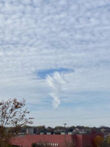
Punch holes can occur after a plane flies through the cloud if the cloud droplets are supercooled, with their temperatures below freezing. (Photo credit: Tim Wagner)

On Nov. 7, numerous “holes” appeared to be punched out of a cloud deck across the Upper Midwest.

Punch holes can occur after a plane flies through the cloud if the cloud droplets are supercooled, with their temperatures below freezing.

A plane flying through a cloud can cause some droplets to freeze. The presence of both liquid water and ice crystal in a cloud yields a unique precipitation-making ability. The water evaporates from the supercooled droplets and flows toward and deposits on the ice crystals. This process is called the Bergeron-Wegener process. It was first proposed by Alfred Wegener in 1911 and explained more extensively by Tor Bergeron.

You can see the ice crystals falling out of the cloud in the accompanying photo, resulting in a cloud-free circle.

There is a difference between freezing a small water droplet and freezing a larger body of water. The freezing temperature of water is 32 degrees at standard pressure. That is the case when water is in dish, ice tray or lake. A 1-millimeter diameter droplet will generally not freeze until the temperature falls below 12.2 degrees. A tiny droplet, but not a large body of water, can be supercooled.
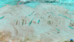
Satellite view of aircraft hole punch clouds over northern Indiana and northeast Illinois.
(Image credit: CIMSS Satellite Blog)

For ice to form, all the water molecules must align in the proper crystal structure. First, a few molecules align, and then the rest quickly follow, turning the liquid into a block of ice. The larger the volume of water, the greater the chances that a few of the molecules will align in the proper manner to form ice when the temperature falls below freezing. In a small volume of water, the chance that some of the molecules will align in the correct structure is reduced, simply because there are fewer molecules.

Steve Ackerman and Jonathan Martin, professors in the UW-Madison department of atmospheric and oceanic sciences, are guests on WHA radio (970 AM) at 11:45 a.m. the last Monday of each month. Send them your questions at stevea@ssec.wisc.edu or jemarti1@wisc.edu.

Category: Meteorology, Phenomena

Comments Off on What are punch holes in clouds?

What is La Niña and the impact on Wisconsin’s coming winter weather?

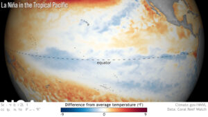
La Niña revealed by satellite sensors: Cooler than average sea surface temperatures are depicted by shades of blue along the equator, indicative of La Niña conditions. (Image credit: NOAA Climate.gov)

La Niña refers to a departure from normal in the sea-surface temperature across much of the eastern tropical Pacific Ocean.

The water temperatures off the west coast of South America are typically 60 to 70 degrees. During a La Niña these waters get as much as 7 degrees colder than normal. La Niña conditions recur every few years and last nine to 12 months, though some events have lingered for as many as two years. This cooling results from a strengthening of the winds over the tropical Pacific and its interaction with the underlying ocean waters.

A La Niña event developed in the tropical Pacific in August-September 2020 and ended in May 2021. La Niña conditions have emerged for 2021, the second winter in a row.

Wisconsin winters tend to have more precipitation and near-average temperatures during a typical La Niña.

The National Oceanic and Atmospheric Administration’s (NOAA’s) seasonal outlooks provide the likelihood that temperatures and total precipitation amounts will be above, near or below average.

La Niña are important events to this seasonal outlook, which does not project seasonal snowfall accumulations as snow forecasts are generally not predictable more than a week in advance. NOAA’s 2021 winter outlook (December 2021 through February 2022) predicts wetter-than-average conditions across portions of the northern U.S., primarily in the Pacific Northwest, northern Rockies, Great Lakes, Ohio Valley and western Alaska. Drier-than-average conditions are favored in south-central Alaska, Southern California, the Southwest and the Southeast.

Above-average temperatures are favored across the South and most of the eastern U.S. Below-average temperatures are favored for southeastern Alaska and the Pacific Northwest eastward to the northern Plains. The Upper Mississippi Valley region has equal chances for temperatures at below, near or above average.

Steve Ackerman and Jonathan Martin, professors in the UW-Madison department of atmospheric and oceanic sciences, are guests on WHA radio (970 AM) at 11:45 a.m. the last Monday of each month. Send them your questions at stevea@ssec.wisc.edu or jemarti1@wisc.edu.
Category: Climate, Meteorology, Seasons

Comments Off on What is La Niña and the impact on Wisconsin’s coming winter weather?

How does frost form?

Trees emit radiation toward the ground insulating small areas which is why frost did not form under the tree in this field. (Photo credit: Tim Wagner)

Frost on objects is just water vapor in the air that has deposited itself as ice onto a surface. Frost forms on objects close to the ground, such as blades of grass.

At night, a blade of grass loses energy by emitting radiation (a non-lethal kind) while it gains energy by absorbing the energy emitted from surrounding objects. Under clear nighttime skies, objects near the ground emit more radiation than they receive from the sky, and so a blade of grass cools as its energy losses are greater than its energy gains. If the temperature of a grass blade gets cold enough and there is sufficient water vapor in the environment, frost will form on the grass.

Overnight cooling of the air near the ground causes morning frost on grass and car windshields. Frost will form on a surface only where the temperature is at or below freezing. The observed air temperature may be higher than 32 degrees, since those air temperature observations are taken at about 4 feet above the ground, where it can be warmer than the ground.

You may notice that frost forms in an open field but not under a tree. Trees emit more radiation toward the ground than does the clear sky. Energy losses at the ground under the tree are therefore less than those of the grass in the open field. The grass in the open field cools faster and reaches the frost point before the grass blades under the tree.

Steve Ackerman and Jonathan Martin, professors in the UW-Madison Department of Atmospheric and Oceanic Sciences, are guests on WHA radio (970 AM) at 11:45 a.m. the last Monday of each month.

Category: Meteorology, Seasons

Comments Off on How does frost form?

What is an atmospheric river?

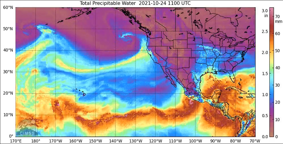
The extreme and persistent drought that has plagued parts of California for several years will be at least slightly remedied by the torrential rains that fell over the weekend over much of the central and northern part of the state.

These rains were associated with a phenomenon called an “atmospheric river.” Atmospheric rivers are organized flows of deep, moist air from the subtropics and tropics that bring many locations in California a large portion of their annual precipitation.

Moisture in the atmosphere measured by satellite microwave instruments depicting the strong atmospheric river impacting the Pacific Northwest on October 24, 2021. Credit: CIMSS

These rivers are not really a distinct feature of the atmosphere, rather they are organized and pushed poleward by the circulations around extratropical cyclones that are strong enough to tap the substantial moisture endemic to the subtropics and tropics.

This weekend’s event is directly tied to the most intense extratropical cyclone to ever visit the waters off the Pacific Northwest. A cyclone with a central pressure in the 944 mb range was just offshore of Washington state. For perspective, the average sea-level pressure is about 1012 mb. Additional perspective on the strength of this storm arises from the fact that category 3 or 4 hurricanes are often characterized by such low central pressures.

The atmospheric river associated with this storm was really a deep flow of moist air ahead of the cold front associated with this monster cyclone. Though it is not truly a distinct meteorological animal, categorizing such moist flows as atmospheric rivers is a useful way to gauge the likely impact of these features on precipitation prospects both in the Central Valley — an enormously important agricultural region of our country — and in the Sierra Nevada, where winter snows are like money in the bank for spring agriculture in Valley.

Steve Ackerman and Jonathan Martin, professors in the UW-Madison Department of Atmospheric and Oceanic sciences, write weekly weather articles in the Wisconsin State Journal and radio guests on WHA (970 AM) at 11:45 a.m. the last Monday of each month. Send them your questions at stevea@ssec.wisc.edu or jemarti1@wisc.edu.

Category: Meteorology, Phenomena, Severe Weather

Comments Off on What is an atmospheric river?

How is the Artic Sea ice situation?

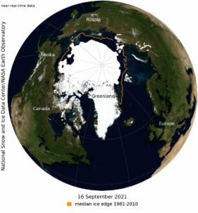
This NASA Blue Marble image shows Arctic sea ice on September 16, 2021, when sea ice reached its minimum extent for the year. Sea ice extent for September 16 averaged 4.72 million square kilometers (1.82 million square miles)—the twelfth lowest in the satellite record. (Image credit: National Snow and Ice Data Center/ NASA Earth Observatory) 

The sea ice cover in the Arctic Ocean is one of the key components of our climate system.

The brightness of the sea ice reflects more solar energy to space than open water. Global warming is amplified in the Arctic as the ice cover decreases. This is referred to as the ice-albedo feedback.

As the polar regions warm, the amount of sea ice decreases, which allows more solar energy to be absorbed by the Arctic Ocean, which increases the warming, leading to more loss of sea ice. In the winter, the sun is below the Arctic Circle and so the sea ice can grow back.

Observing sea ice coverage from satellites started in 1978. Those satellite-based observations have measured rapid changes in ice coverage, and that coverage has been declining. The overall, downward trend in the minimum extent from 1979 to 2021 is 13% per decade relative to the 1981 to 2010 average. The loss of sea ice is about 31,100 square miles per year, equivalent to losing the size of the state of South Carolina.

The Arctic Sea ice coverage typically reaches its smallest amount in mid-September. This is in response to the setting sun and falling temperatures. Then, the ice extent begins to increase and does throughout the winter. This year, based on satellite observations, the minimum occurred on Sept. 16 of 1.82 million square miles. The 2021 minimum is the 12th lowest in the satellite record. The last 15 years are the lowest 15 sea ice extents in the satellite record.

Multiyear ice is sea ice that exists for more than one year. Multiyear ice extent is one of the lowest on record.

Steve Ackerman and Jonathan Martin, professors in the UW-Madison department of atmospheric and oceanic sciences, are guests on WHA radio (970 AM) at 11:45 a.m. the last Monday of each month. Send them your questions at stevea@ssec.wisc.edu or jemarti1@wisc.edu.
Category: Climate, Meteorology, Seasons

Comments Off on How is the Artic Sea ice situation?